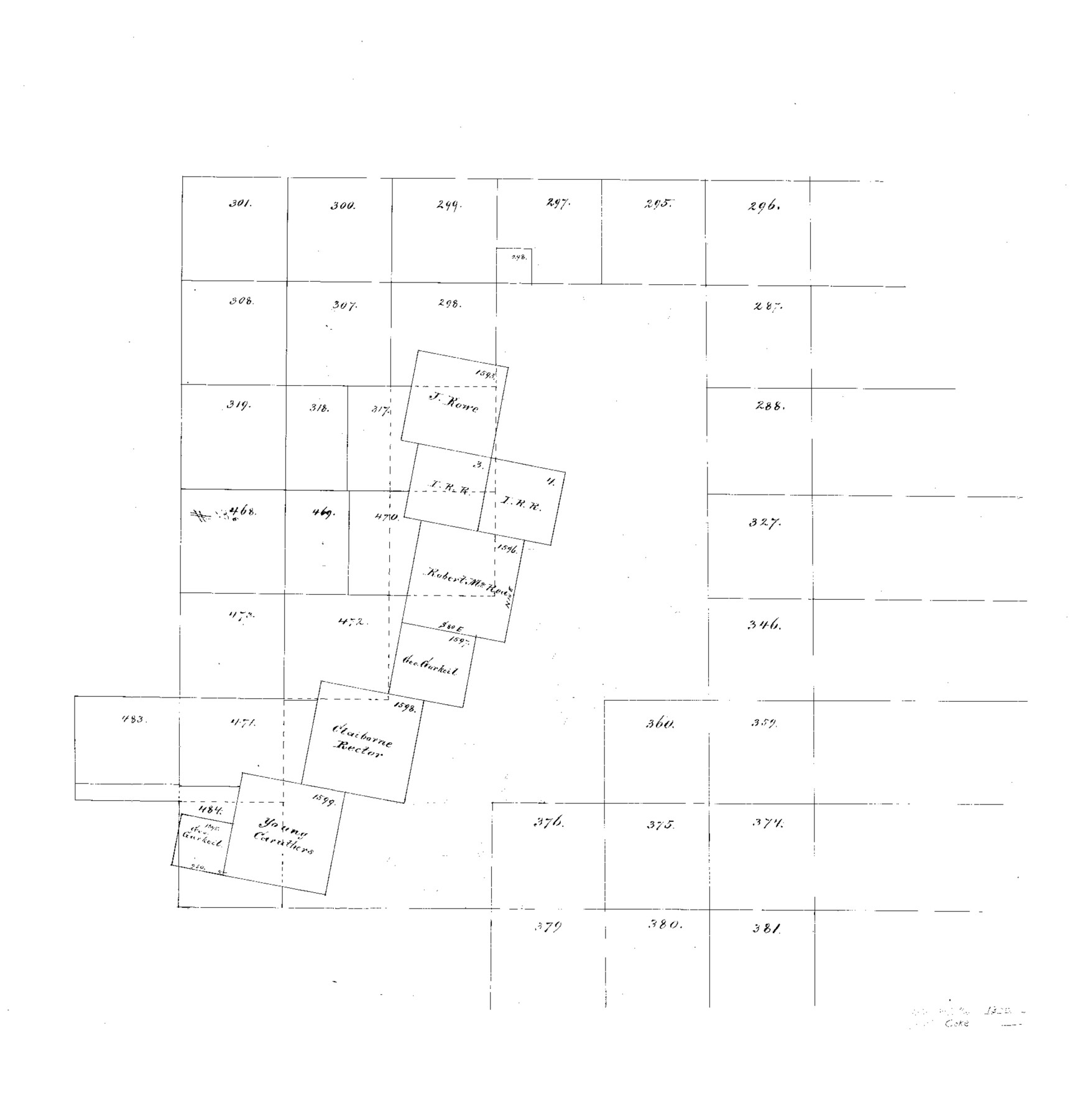
Coke County Sketch File 13a
[Sketch of large area north of Robert Lee]
-
Map/Doc
11107
-
Collection
General Map Collection
-
Counties
Coke
-
Subjects
Surveying Sketch File
-
Height x Width
20.3 x 19.5 inches
51.6 x 49.5 cm
-
Medium
paper, manuscript
Part of: General Map Collection
United States - Gulf Coast Texas - Northern part of Laguna Madre

Print $20.00
- Digital $50.00
United States - Gulf Coast Texas - Northern part of Laguna Madre
1923
Size 26.7 x 18.2 inches
Map/Doc 72930
Bandera County Working Sketch 22

Print $20.00
- Digital $50.00
Bandera County Working Sketch 22
1949
Size 42.8 x 24.9 inches
Map/Doc 67618
Menard County Boundary File 12

Print $66.00
- Digital $50.00
Menard County Boundary File 12
Size 8.7 x 8.7 inches
Map/Doc 57099
Morris County Rolled Sketch 2A

Print $20.00
- Digital $50.00
Morris County Rolled Sketch 2A
Size 24.1 x 18.9 inches
Map/Doc 10261
Liberty County Sketch File 21

Print $5.00
- Digital $50.00
Liberty County Sketch File 21
1858
Size 7.9 x 13.0 inches
Map/Doc 29928
University Land in Grayson County in Two Parts

Print $20.00
- Digital $50.00
University Land in Grayson County in Two Parts
Size 30.6 x 25.8 inches
Map/Doc 62965
Eastland County Rolled Sketch 24

Print $20.00
- Digital $50.00
Eastland County Rolled Sketch 24
1983
Size 33.5 x 38.0 inches
Map/Doc 8830
Runnels County

Print $40.00
- Digital $50.00
Runnels County
1948
Size 48.8 x 38.8 inches
Map/Doc 73278
Orange County Working Sketch 1

Print $20.00
- Digital $50.00
Orange County Working Sketch 1
1914
Size 16.1 x 18.2 inches
Map/Doc 71333
Lynn County Boundary File 9

Print $24.00
- Digital $50.00
Lynn County Boundary File 9
Size 11.3 x 8.8 inches
Map/Doc 56657
Crockett County Working Sketch 52

Print $20.00
- Digital $50.00
Crockett County Working Sketch 52
1941
Size 26.0 x 33.5 inches
Map/Doc 68385
Brazoria County Sketch File 24

Print $6.00
- Digital $50.00
Brazoria County Sketch File 24
1868
Size 11.3 x 10.4 inches
Map/Doc 15022
You may also like
Cottle County Sketch File 2

Print $20.00
- Digital $50.00
Cottle County Sketch File 2
1882
Size 32.9 x 19.6 inches
Map/Doc 76757
Map of the Gainesville, Henrietta & Western Railway

Print $20.00
- Digital $50.00
Map of the Gainesville, Henrietta & Western Railway
1887
Size 9.6 x 41.7 inches
Map/Doc 64482
Rusk County Sketch File 8

Print $4.00
Rusk County Sketch File 8
1856
Size 12.7 x 8.2 inches
Map/Doc 35503
Montague County Working Sketch 6

Print $20.00
- Digital $50.00
Montague County Working Sketch 6
1923
Size 16.9 x 27.2 inches
Map/Doc 71072
Pecos County Rolled Sketch 191

Print $20.00
- Digital $50.00
Pecos County Rolled Sketch 191
Size 18.2 x 27.4 inches
Map/Doc 95397
Mills County Boundary File 3

Print $30.00
- Digital $50.00
Mills County Boundary File 3
Size 11.0 x 8.6 inches
Map/Doc 57281
Freestone County Sketch File 9

Print $4.00
- Digital $50.00
Freestone County Sketch File 9
1859
Size 7.9 x 8.3 inches
Map/Doc 23056
San Jacinto Co.

Print $20.00
- Digital $50.00
San Jacinto Co.
1889
Size 46.4 x 37.9 inches
Map/Doc 63016
Hudspeth County Working Sketch 48

Print $20.00
- Digital $50.00
Hudspeth County Working Sketch 48
1984
Size 36.6 x 46.3 inches
Map/Doc 66333
Jim Wells County Working Sketch 4

Print $20.00
- Digital $50.00
Jim Wells County Working Sketch 4
1938
Size 44.1 x 32.8 inches
Map/Doc 66602
Kenedy County Working Sketch 3

Print $20.00
- Digital $50.00
Kenedy County Working Sketch 3
1903
Size 30.3 x 38.4 inches
Map/Doc 70005
[Sketch for Mineral Application 1112 - Colorado River, H. E. Chambers]
![65642, [Sketch for Mineral Application 1112 - Colorado River, H. E. Chambers], General Map Collection](https://historictexasmaps.com/wmedia_w700/maps/65642.tif.jpg)
Print $20.00
- Digital $50.00
[Sketch for Mineral Application 1112 - Colorado River, H. E. Chambers]
1918
Size 17.1 x 28.4 inches
Map/Doc 65642