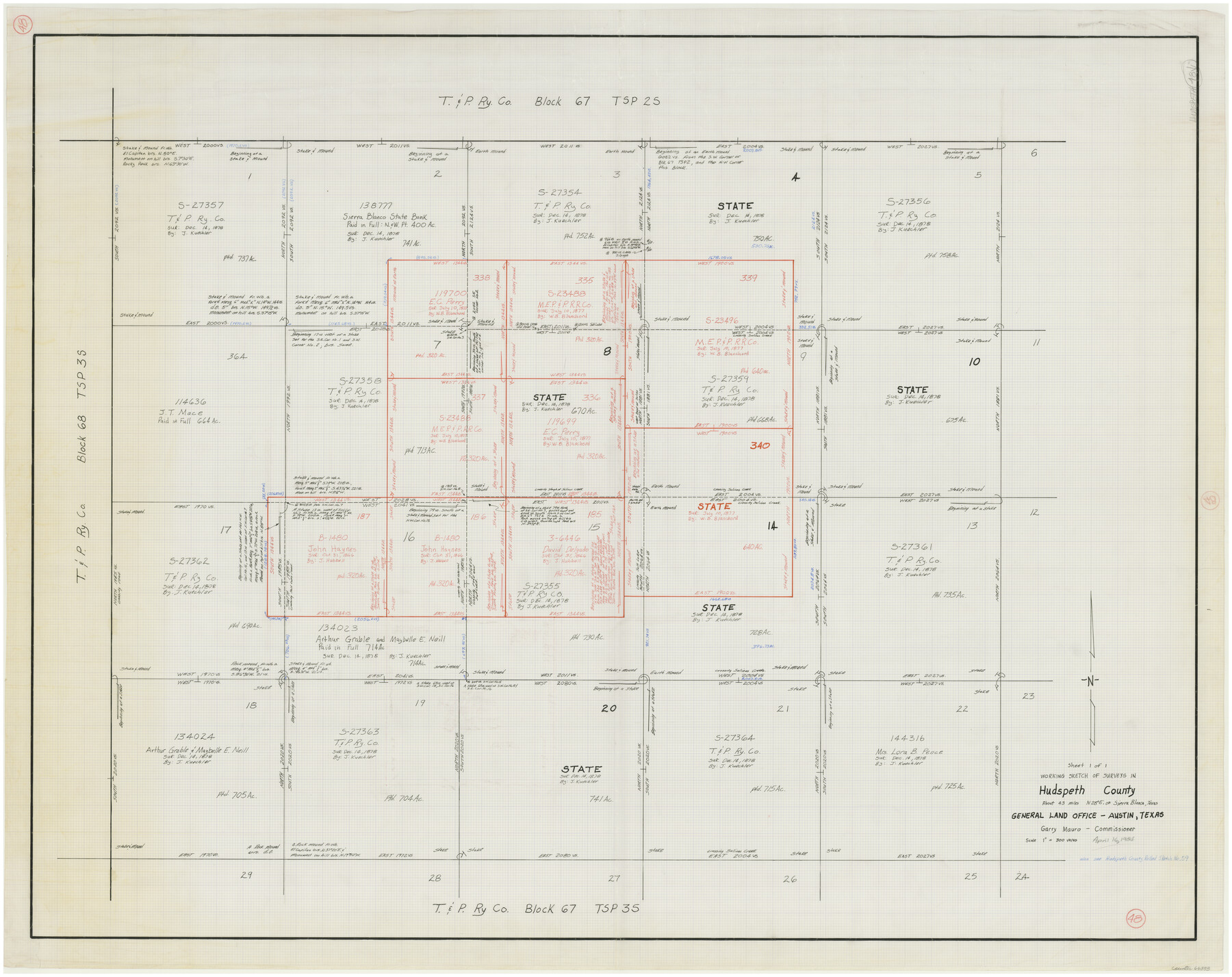
Hudspeth County Working Sketch 48
-
Map/Doc
66333
-
Collection
General Map Collection
-
Object Dates
4/16/1984 (Creation Date)
-
Counties
Hudspeth
-
Subjects
Surveying Working Sketch
-
Height x Width
36.6 x 46.3 inches
93.0 x 117.6 cm
-
Scale
1" = 300 varas
-
Comments
See Hudspeth County Rolled Sketch 59 (9224).
Related maps
Hudspeth County Rolled Sketch 59

Print $40.00
- Digital $50.00
Hudspeth County Rolled Sketch 59
Size 69.2 x 42.8 inches
Map/Doc 9224
Part of: General Map Collection
Zavala County Working Sketch 17

Print $20.00
- Digital $50.00
Zavala County Working Sketch 17
1977
Size 40.7 x 34.1 inches
Map/Doc 62092
Marion County Rolled Sketch 2

Print $20.00
- Digital $50.00
Marion County Rolled Sketch 2
1954
Size 34.8 x 45.9 inches
Map/Doc 46621
Atascosa County Working Sketch 1b

Print $20.00
- Digital $50.00
Atascosa County Working Sketch 1b
1908
Size 36.2 x 39.0 inches
Map/Doc 67195
Brewster County Sketch File N-17

Print $80.00
- Digital $50.00
Brewster County Sketch File N-17
1939
Size 8.9 x 14.4 inches
Map/Doc 15651
Andrews County Sketch File 20

Print $6.00
- Digital $50.00
Andrews County Sketch File 20
Size 11.2 x 8.7 inches
Map/Doc 12916
Brewster County Rolled Sketch 91

Print $20.00
- Digital $50.00
Brewster County Rolled Sketch 91
1949
Size 27.5 x 15.3 inches
Map/Doc 5249
Caldwell County Working Sketch 5

Print $20.00
- Digital $50.00
Caldwell County Working Sketch 5
1940
Size 19.9 x 27.4 inches
Map/Doc 67835
Harris County Rolled Sketch 86

Print $20.00
- Digital $50.00
Harris County Rolled Sketch 86
Size 20.7 x 42.9 inches
Map/Doc 73578
Map of the East Part of Tom Green County

Print $20.00
- Digital $50.00
Map of the East Part of Tom Green County
1894
Size 21.5 x 23.1 inches
Map/Doc 4083
Wilbarger County Sketch File 23

Print $4.00
- Digital $50.00
Wilbarger County Sketch File 23
1887
Size 14.2 x 8.8 inches
Map/Doc 40223
Map of Karnes County

Print $20.00
- Digital $50.00
Map of Karnes County
1856
Size 26.2 x 22.4 inches
Map/Doc 3745
Flight Mission No. DIX-8P, Frame 93, Aransas County

Print $20.00
- Digital $50.00
Flight Mission No. DIX-8P, Frame 93, Aransas County
1956
Size 18.5 x 22.3 inches
Map/Doc 83918
You may also like
Flight Mission No. BRA-8M, Frame 134, Jefferson County

Print $20.00
- Digital $50.00
Flight Mission No. BRA-8M, Frame 134, Jefferson County
1953
Size 18.6 x 22.5 inches
Map/Doc 85630
Montgomery County Working Sketch 64

Print $20.00
- Digital $50.00
Montgomery County Working Sketch 64
1965
Size 27.9 x 33.7 inches
Map/Doc 71171
Briscoe County Sketch File 1

Print $5.00
- Digital $50.00
Briscoe County Sketch File 1
1880
Size 9.1 x 14.8 inches
Map/Doc 16413
[Part of H. & G. N. Blocks 2 and D-13]
![90490, [Part of H. & G. N. Blocks 2 and D-13], Twichell Survey Records](https://historictexasmaps.com/wmedia_w700/maps/90490-1.tif.jpg)
Print $20.00
- Digital $50.00
[Part of H. & G. N. Blocks 2 and D-13]
1907
Size 14.1 x 17.7 inches
Map/Doc 90490
Flight Mission No. BRA-8M, Frame 69, Jefferson County

Print $20.00
- Digital $50.00
Flight Mission No. BRA-8M, Frame 69, Jefferson County
1953
Size 18.6 x 22.1 inches
Map/Doc 85589
Denton County Sketch File 18

Print $4.00
- Digital $50.00
Denton County Sketch File 18
1856
Size 7.9 x 7.3 inches
Map/Doc 20731
Upton County Sketch File 41

Print $20.00
- Digital $50.00
Upton County Sketch File 41
1964
Size 33.8 x 26.0 inches
Map/Doc 12525
Flight Mission No. DCL-7C, Frame 113, Kenedy County

Print $20.00
- Digital $50.00
Flight Mission No. DCL-7C, Frame 113, Kenedy County
1943
Size 18.5 x 22.2 inches
Map/Doc 86078
Flight Mission No. CRC-3R, Frame 43, Chambers County

Print $20.00
- Digital $50.00
Flight Mission No. CRC-3R, Frame 43, Chambers County
1956
Size 18.5 x 22.3 inches
Map/Doc 84816
[University Lands Block 16 and Blocks 194, Z and part of 12]
![91618, [University Lands Block 16 and Blocks 194, Z and part of 12], Twichell Survey Records](https://historictexasmaps.com/wmedia_w700/maps/91618-1.tif.jpg)
Print $20.00
- Digital $50.00
[University Lands Block 16 and Blocks 194, Z and part of 12]
1911
Size 32.2 x 23.3 inches
Map/Doc 91618
Mason County Working Sketch 8

Print $20.00
- Digital $50.00
Mason County Working Sketch 8
1946
Size 22.9 x 32.3 inches
Map/Doc 70844
Webb County Working Sketch 76

Print $20.00
- Digital $50.00
Webb County Working Sketch 76
1975
Size 43.3 x 37.5 inches
Map/Doc 72443