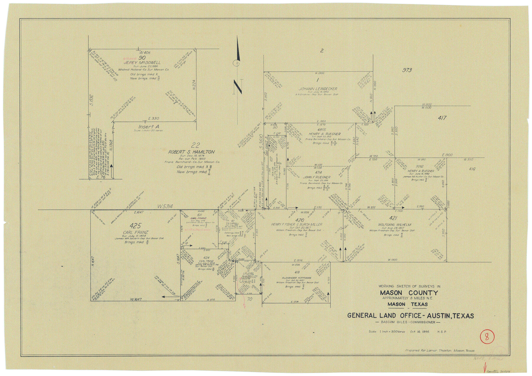
Mason County Working Sketch 8
-
Map/Doc
70844
-
Collection
General Map Collection
-
Object Dates
10/16/1946 (Creation Date)
-
Counties
Mason
-
Subjects
Surveying Working Sketch
-
Height x Width
22.9 x 32.3 inches
58.2 x 82.0 cm
-
Scale
1" = 300 varas
Part of: General Map Collection
Bowie County Sketch File 7b

Print $10.00
- Digital $50.00
Bowie County Sketch File 7b
1927
Size 10.7 x 8.6 inches
Map/Doc 14859
Sutton County Rolled Sketch 60

Print $20.00
- Digital $50.00
Sutton County Rolled Sketch 60
1964
Size 23.5 x 34.7 inches
Map/Doc 7897
Pecos County Working Sketch 141

Print $20.00
- Digital $50.00
Pecos County Working Sketch 141
1941
Size 31.8 x 42.5 inches
Map/Doc 9733
Cochran County Sketch File 6

Print $10.00
- Digital $50.00
Cochran County Sketch File 6
1938
Size 11.2 x 8.6 inches
Map/Doc 18545
Flight Mission No. CGI-1N, Frame 137, Cameron County

Print $20.00
- Digital $50.00
Flight Mission No. CGI-1N, Frame 137, Cameron County
1955
Size 15.5 x 18.8 inches
Map/Doc 84493
Flight Mission No. DIX-10P, Frame 147, Aransas County

Print $20.00
- Digital $50.00
Flight Mission No. DIX-10P, Frame 147, Aransas County
1956
Size 18.7 x 22.4 inches
Map/Doc 83949
Burleson County Working Sketch 38

Print $20.00
- Digital $50.00
Burleson County Working Sketch 38
1985
Size 23.0 x 27.5 inches
Map/Doc 67757
Live Oak County Sketch File 15

Print $4.00
- Digital $50.00
Live Oak County Sketch File 15
Size 12.6 x 8.1 inches
Map/Doc 30280
Dawson County Sketch File 17

Print $18.00
- Digital $50.00
Dawson County Sketch File 17
Size 14.4 x 8.8 inches
Map/Doc 20558
El Paso County Rolled Sketch VD

Print $40.00
- Digital $50.00
El Paso County Rolled Sketch VD
1915
Size 18.4 x 67.4 inches
Map/Doc 8862
Duval County Rolled Sketch 33B

Print $40.00
- Digital $50.00
Duval County Rolled Sketch 33B
1949
Size 42.5 x 76.2 inches
Map/Doc 8819
Potter County Working Sketch 10

Print $20.00
- Digital $50.00
Potter County Working Sketch 10
1964
Size 32.6 x 25.0 inches
Map/Doc 71670
You may also like
Dallam County Sketch File 1

Print $22.00
- Digital $50.00
Dallam County Sketch File 1
1885
Size 29.5 x 27.1 inches
Map/Doc 11277
Brewster County Rolled Sketch 158

Print $20.00
- Digital $50.00
Brewster County Rolled Sketch 158
2007
Size 24.6 x 36.5 inches
Map/Doc 89623
[LIT Ranch, Gunter & Munson surveys 52-55, Canadian River Meander]
![93011, [LIT Ranch, Gunter & Munson surveys 52-55, Canadian River Meander], Twichell Survey Records](https://historictexasmaps.com/wmedia_w700/maps/93011-1.tif.jpg)
Print $20.00
- Digital $50.00
[LIT Ranch, Gunter & Munson surveys 52-55, Canadian River Meander]
Size 18.4 x 12.8 inches
Map/Doc 93011
Travis County Working Sketch 40

Print $20.00
- Digital $50.00
Travis County Working Sketch 40
1974
Size 31.7 x 32.1 inches
Map/Doc 69424
Flight Mission No. CRC-3R, Frame 206, Chambers County

Print $20.00
- Digital $50.00
Flight Mission No. CRC-3R, Frame 206, Chambers County
1956
Size 18.5 x 22.2 inches
Map/Doc 84861
Aransas County Working Sketch 17

Print $20.00
- Digital $50.00
Aransas County Working Sketch 17
1965
Size 27.2 x 21.1 inches
Map/Doc 67184
Controlled Mosaic by Jack Amman Photogrammetric Engineers, Inc - Sheet 30

Print $20.00
- Digital $50.00
Controlled Mosaic by Jack Amman Photogrammetric Engineers, Inc - Sheet 30
1954
Size 20.0 x 24.0 inches
Map/Doc 83483
Intracoastal Waterway, Houma, LA to Corpus Christi, TX

Print $20.00
- Digital $50.00
Intracoastal Waterway, Houma, LA to Corpus Christi, TX
Size 22.0 x 25.0 inches
Map/Doc 61905
Red River, Bois D'Arc Creek Floodway Sheet No. 1

Print $20.00
- Digital $50.00
Red River, Bois D'Arc Creek Floodway Sheet No. 1
1915
Size 28.8 x 25.9 inches
Map/Doc 69656
Padre Island, Register No. 1485b

Print $40.00
- Digital $50.00
Padre Island, Register No. 1485b
1881
Size 55.6 x 37.3 inches
Map/Doc 73608
Flight Mission No. CLL-1N, Frame 86, Willacy County

Print $20.00
- Digital $50.00
Flight Mission No. CLL-1N, Frame 86, Willacy County
1954
Size 18.4 x 22.1 inches
Map/Doc 87032
Pecos County Rolled Sketch 116

Print $20.00
- Digital $50.00
Pecos County Rolled Sketch 116
Size 26.7 x 20.6 inches
Map/Doc 7259