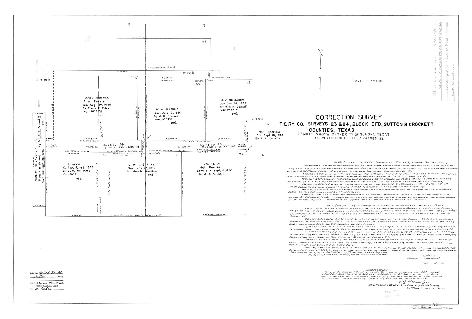
Sutton County Rolled Sketch 60
Correction survey, T. C. Ry. Co. surveys 23 & 24, Block EFD, Sutton & Crockett Counties, Texas
-
Map/Doc
7897
-
Collection
General Map Collection
-
Object Dates
1964/3/15 (Creation Date)
1964/3/25 (File Date)
-
People and Organizations
R.Q. Harris (Surveyor/Engineer)
-
Counties
Sutton Crockett
-
Subjects
Surveying Rolled Sketch
-
Height x Width
23.5 x 34.7 inches
59.7 x 88.1 cm
-
Scale
1" = 400 varas
Part of: General Map Collection
Washington County

Print $20.00
- Digital $50.00
Washington County
1920
Size 32.5 x 47.2 inches
Map/Doc 16918
Flight Mission No. BRE-1P, Frame 126, Nueces County

Print $20.00
- Digital $50.00
Flight Mission No. BRE-1P, Frame 126, Nueces County
1956
Size 18.4 x 22.4 inches
Map/Doc 86692
La Salle County Boundary File 2

Print $2.00
- Digital $50.00
La Salle County Boundary File 2
Size 11.1 x 8.6 inches
Map/Doc 56241
[Gulf, Colorado & Santa Fe]
![64575, [Gulf, Colorado & Santa Fe], General Map Collection](https://historictexasmaps.com/wmedia_w700/maps/64575.tif.jpg)
Print $40.00
- Digital $50.00
[Gulf, Colorado & Santa Fe]
Size 31.9 x 71.7 inches
Map/Doc 64575
Map of Williamson County

Print $20.00
- Digital $50.00
Map of Williamson County
1876
Size 21.2 x 28.6 inches
Map/Doc 4152
Hidalgo County Sketch File 2

Print $14.00
- Digital $50.00
Hidalgo County Sketch File 2
1877
Size 10.1 x 8.1 inches
Map/Doc 26394
Hamilton County Sketch File 14

Print $10.00
- Digital $50.00
Hamilton County Sketch File 14
Size 10.1 x 8.0 inches
Map/Doc 24937
Hale County Sketch File 15

Print $20.00
- Digital $50.00
Hale County Sketch File 15
Size 22.7 x 18.6 inches
Map/Doc 11596
McMullen County Working Sketch 7

Print $20.00
- Digital $50.00
McMullen County Working Sketch 7
1926
Size 20.7 x 17.5 inches
Map/Doc 70708
Hardin County Working Sketch 22

Print $20.00
- Digital $50.00
Hardin County Working Sketch 22
1948
Size 20.9 x 31.6 inches
Map/Doc 63420
Ward County Working Sketch 40

Print $20.00
- Digital $50.00
Ward County Working Sketch 40
1969
Size 24.4 x 45.7 inches
Map/Doc 72346
Grayson County

Print $20.00
- Digital $50.00
Grayson County
1935
Size 43.4 x 40.5 inches
Map/Doc 95512
You may also like
Plat of a survey of the North part of section 16, Block 362, Martha McBride, Presidio County, Texas

Print $4.00
- Digital $50.00
Plat of a survey of the North part of section 16, Block 362, Martha McBride, Presidio County, Texas
1989
Size 24.1 x 29.3 inches
Map/Doc 60520
Copy of Surveyor's Field Book, Morris Browning - In Blocks 7, 5 & 4, I&GNRRCo., Hutchinson and Carson Counties, Texas

Print $2.00
- Digital $50.00
Copy of Surveyor's Field Book, Morris Browning - In Blocks 7, 5 & 4, I&GNRRCo., Hutchinson and Carson Counties, Texas
1888
Size 6.9 x 8.8 inches
Map/Doc 62283
Jefferson County Boundary File 1

Print $10.00
- Digital $50.00
Jefferson County Boundary File 1
Size 9.8 x 6.7 inches
Map/Doc 55514
Umbarger in Randall County, Texas

Print $20.00
- Digital $50.00
Umbarger in Randall County, Texas
1905
Size 31.9 x 30.8 inches
Map/Doc 92158
Webb County Working Sketch 74

Print $20.00
- Digital $50.00
Webb County Working Sketch 74
1975
Size 17.0 x 30.0 inches
Map/Doc 72441
Gonzales County Rolled Sketch 1

Print $20.00
- Digital $50.00
Gonzales County Rolled Sketch 1
1917
Size 21.9 x 23.9 inches
Map/Doc 6027
[Maps of surveys in Reeves & Culberson Cos]
![61145, [Maps of surveys in Reeves & Culberson Cos], General Map Collection](https://historictexasmaps.com/wmedia_w700/maps/61145.tif.jpg)
Print $20.00
- Digital $50.00
[Maps of surveys in Reeves & Culberson Cos]
1937
Size 30.8 x 25.0 inches
Map/Doc 61145
Exhibit G Robert Violette M. A. 34719 Gaines County, Texas

Print $40.00
- Digital $50.00
Exhibit G Robert Violette M. A. 34719 Gaines County, Texas
Size 56.1 x 23.2 inches
Map/Doc 89683
Waller County

Print $40.00
- Digital $50.00
Waller County
1945
Size 48.0 x 28.5 inches
Map/Doc 63108
Martha's Vineyard to Block Island Including Western Approach to Cape Cod Canal

Print $20.00
- Digital $50.00
Martha's Vineyard to Block Island Including Western Approach to Cape Cod Canal
1963
Size 37.5 x 45.7 inches
Map/Doc 73554
Houston County Working Sketch 35

Print $20.00
- Digital $50.00
Houston County Working Sketch 35
1999
Size 27.8 x 29.0 inches
Map/Doc 66265
Crosby County Sketch File 18

Print $26.00
- Digital $50.00
Crosby County Sketch File 18
1905
Size 14.2 x 8.5 inches
Map/Doc 20071