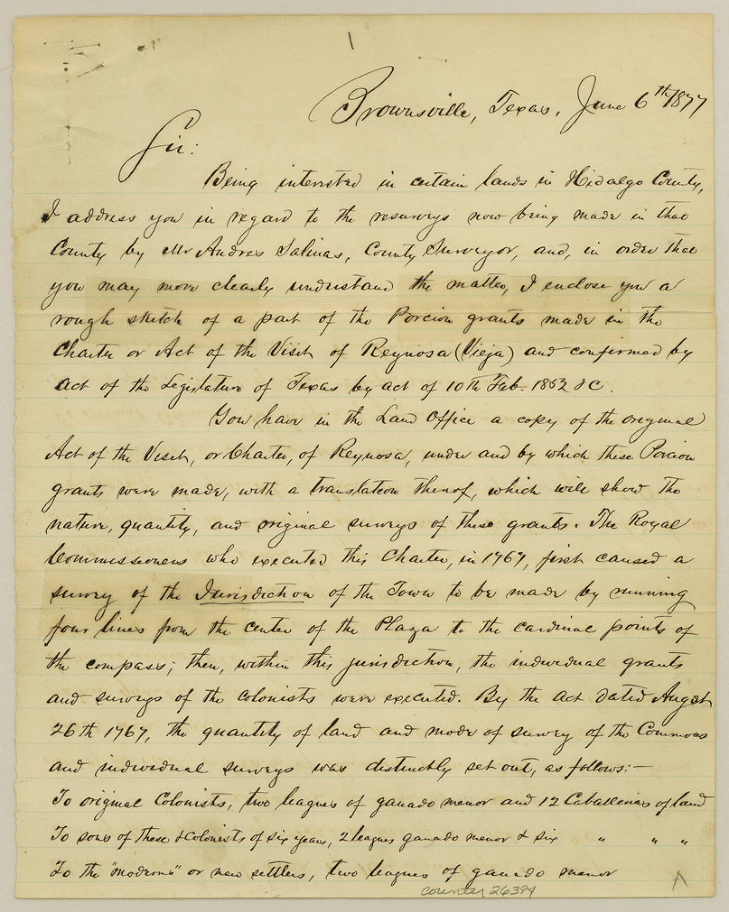
Hidalgo County Sketch File 2
[Letter regarding porcions surveyed by Andres Salinas]
-
Map/Doc
26394
-
Collection
General Map Collection
-
Object Dates
6/6/1877 (Creation Date)
6/6/1877 (Correspondence Date)
1767 (Survey Date)
3/16/1875 (Correspondence Date)
3/18/1875 (File Date)
-
People and Organizations
Andres Salinas (Surveyor/Engineer)
J.L. Haynes (Surveyor/Engineer)
-
Counties
Hidalgo
-
Subjects
Surveying Sketch File
-
Height x Width
10.1 x 8.1 inches
25.7 x 20.6 cm
-
Medium
paper, manuscript
-
Features
Rio Grande
Reynosa
Part of: General Map Collection
[Surveys along the Trinity River]
![321, [Surveys along the Trinity River], General Map Collection](https://historictexasmaps.com/wmedia_w700/maps/321.tif.jpg)
Print $2.00
- Digital $50.00
[Surveys along the Trinity River]
Size 3.6 x 3.7 inches
Map/Doc 321
Orange County Working Sketch 41

Print $20.00
- Digital $50.00
Orange County Working Sketch 41
1979
Size 28.0 x 18.2 inches
Map/Doc 71373
Brown County Working Sketch Graphic Index

Print $20.00
- Digital $50.00
Brown County Working Sketch Graphic Index
1944
Size 47.6 x 37.1 inches
Map/Doc 76480
La Salle County Working Sketch 27

Print $20.00
- Digital $50.00
La Salle County Working Sketch 27
1949
Size 15.2 x 23.6 inches
Map/Doc 70328
Terry County Working Sketch 2

Print $20.00
- Digital $50.00
Terry County Working Sketch 2
1952
Size 19.3 x 19.3 inches
Map/Doc 62107
Houston County Sketch File 36

Print $40.00
- Digital $50.00
Houston County Sketch File 36
1945
Size 15.6 x 14.2 inches
Map/Doc 26817
Hutchinson County Working Sketch 42

Print $20.00
- Digital $50.00
Hutchinson County Working Sketch 42
1978
Size 27.3 x 23.2 inches
Map/Doc 66402
Real County Working Sketch Graphic Index, Sheet 1 (Sketches 1 to 42)

Print $20.00
- Digital $50.00
Real County Working Sketch Graphic Index, Sheet 1 (Sketches 1 to 42)
1972
Size 42.9 x 31.0 inches
Map/Doc 76678
Bee County Sketch File 23

Print $8.00
- Digital $50.00
Bee County Sketch File 23
1878
Size 10.0 x 8.1 inches
Map/Doc 14318
Falls County Sketch File 3

Print $3.00
- Digital $50.00
Falls County Sketch File 3
1847
Size 10.8 x 16.5 inches
Map/Doc 11465
Gillespie County Boundary File 1

Print $30.00
- Digital $50.00
Gillespie County Boundary File 1
Size 8.5 x 3.8 inches
Map/Doc 53709
Matagorda County Working Sketch 9

Print $20.00
- Digital $50.00
Matagorda County Working Sketch 9
1954
Size 26.5 x 22.3 inches
Map/Doc 70867
You may also like
Harris County Rolled Sketch 26

Print $20.00
- Digital $50.00
Harris County Rolled Sketch 26
Size 28.2 x 41.3 inches
Map/Doc 6094
Nueces County Sketch File 21

Print $8.00
- Digital $50.00
Nueces County Sketch File 21
1880
Size 5.9 x 5.5 inches
Map/Doc 32557
Flight Mission No. CGI-3N, Frame 107, Cameron County

Print $20.00
- Digital $50.00
Flight Mission No. CGI-3N, Frame 107, Cameron County
1954
Size 18.6 x 22.3 inches
Map/Doc 84587
Flight Mission No. BRA-16M, Frame 66, Jefferson County

Print $20.00
- Digital $50.00
Flight Mission No. BRA-16M, Frame 66, Jefferson County
1953
Size 18.6 x 22.3 inches
Map/Doc 85683
Map of the River Sabine from Logan's Ferry to 32nd Degree of North Latitude

Print $20.00
Map of the River Sabine from Logan's Ferry to 32nd Degree of North Latitude
1841
Size 21.4 x 27.8 inches
Map/Doc 88902
Bell County Sketch File 11

Print $4.00
- Digital $50.00
Bell County Sketch File 11
1852
Size 9.9 x 7.8 inches
Map/Doc 14383
General Highway Map. Detail of Cities and Towns in Milam County, Texas [Rockdale and Cameron and vicinities]
![79598, General Highway Map. Detail of Cities and Towns in Milam County, Texas [Rockdale and Cameron and vicinities], Texas State Library and Archives](https://historictexasmaps.com/wmedia_w700/maps/79598.tif.jpg)
Print $20.00
General Highway Map. Detail of Cities and Towns in Milam County, Texas [Rockdale and Cameron and vicinities]
1961
Size 18.1 x 24.6 inches
Map/Doc 79598
Kerr County Rolled Sketch 15

Print $20.00
- Digital $50.00
Kerr County Rolled Sketch 15
1951
Size 14.8 x 20.8 inches
Map/Doc 7720
Callahan County Working Sketch 11

Print $40.00
- Digital $50.00
Callahan County Working Sketch 11
1978
Size 43.0 x 48.1 inches
Map/Doc 67893
Frio County Rolled Sketch 12

Print $20.00
- Digital $50.00
Frio County Rolled Sketch 12
1948
Size 36.5 x 45.5 inches
Map/Doc 8904
Tom Green County Sketch File 71

Print $20.00
- Digital $50.00
Tom Green County Sketch File 71
1948
Size 17.5 x 20.6 inches
Map/Doc 12447
San Augustine County Sketch File 1

Print $4.00
San Augustine County Sketch File 1
1849
Size 9.3 x 8.2 inches
Map/Doc 35631