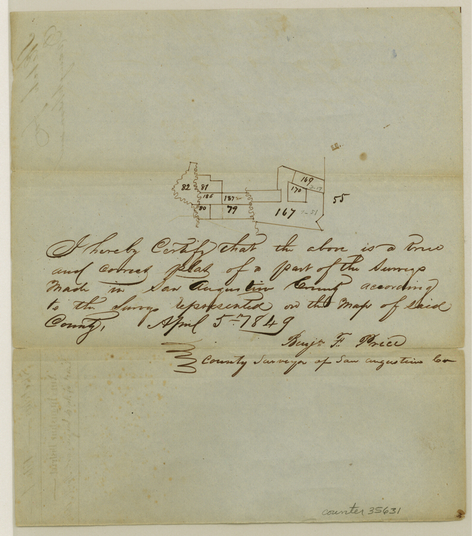
San Augustine County Sketch File 1
[Sketch of unknown area allegedly east of Ayish Bayou]
-
Map/Doc
35631
-
Collection
General Map Collection
-
Object Dates
4/5/1849 (Creation Date)
-
People and Organizations
Benjamin F. Price (Surveyor/Engineer)
-
Counties
San Augustine
-
Subjects
Surveying Sketch File
-
Height x Width
9.3 x 8.2 inches
23.6 x 20.8 cm
-
Medium
paper, manuscript
-
Features
Ayish Bayou
Part of: General Map Collection
Flight Mission No. BRA-7M, Frame 6, Jefferson County

Print $20.00
- Digital $50.00
Flight Mission No. BRA-7M, Frame 6, Jefferson County
1953
Size 18.5 x 22.3 inches
Map/Doc 85457
Crockett County Rolled Sketch S

Print $20.00
- Digital $50.00
Crockett County Rolled Sketch S
Size 8.3 x 21.2 inches
Map/Doc 5639
Val Verde County Sketch File 32

Print $20.00
- Digital $50.00
Val Verde County Sketch File 32
Size 45.1 x 20.1 inches
Map/Doc 10420
Hall County Sketch File B1

Print $20.00
- Digital $50.00
Hall County Sketch File B1
1904
Size 23.4 x 25.4 inches
Map/Doc 11612
Stephens County Working Sketch 22

Print $40.00
- Digital $50.00
Stephens County Working Sketch 22
1975
Size 32.9 x 49.0 inches
Map/Doc 63965
Flight Mission No. BQR-5K, Frame 64, Brazoria County

Print $20.00
- Digital $50.00
Flight Mission No. BQR-5K, Frame 64, Brazoria County
1952
Size 18.8 x 22.5 inches
Map/Doc 84009
San Jacinto County Rolled Sketch 14

Print $20.00
- Digital $50.00
San Jacinto County Rolled Sketch 14
1998
Size 25.7 x 37.2 inches
Map/Doc 7570
Brewster County Sketch File NS-13

Print $4.00
- Digital $50.00
Brewster County Sketch File NS-13
1955
Size 11.1 x 8.8 inches
Map/Doc 16220
Williamson County Sketch File 11

Print $4.00
- Digital $50.00
Williamson County Sketch File 11
Size 8.2 x 9.2 inches
Map/Doc 40324
Val Verde County Working Sketch 15

Print $20.00
- Digital $50.00
Val Verde County Working Sketch 15
1926
Size 35.3 x 25.0 inches
Map/Doc 72150
Jasper County

Print $40.00
- Digital $50.00
Jasper County
1946
Size 49.8 x 43.9 inches
Map/Doc 95542

You may also like
Atascosa County Sketch File 12

Print $4.00
- Digital $50.00
Atascosa County Sketch File 12
1862
Size 14.4 x 8.3 inches
Map/Doc 13769
Burnet County Rolled Sketch D1

Print $20.00
- Digital $50.00
Burnet County Rolled Sketch D1
1924
Size 22.2 x 18.5 inches
Map/Doc 5358
Williamson County Working Sketch Graphic Index

Print $40.00
- Digital $50.00
Williamson County Working Sketch Graphic Index
1946
Size 38.4 x 55.7 inches
Map/Doc 76742
Panola County Sketch File 30

Print $4.00
- Digital $50.00
Panola County Sketch File 30
1944
Size 2.8 x 8.9 inches
Map/Doc 33505
Taylor County Rolled Sketch 30A

Print $20.00
- Digital $50.00
Taylor County Rolled Sketch 30A
Size 17.5 x 11.3 inches
Map/Doc 76410
Flight Mission No. DIX-8P, Frame 72, Aransas County

Print $20.00
- Digital $50.00
Flight Mission No. DIX-8P, Frame 72, Aransas County
1956
Size 18.7 x 22.4 inches
Map/Doc 83903
[Sketch Showing Wm. T. Brewer, John R. Taylor, Wm. F. Butler, Timothy DeVore, L. M. Thorn and adjoining surveys]
![90121, [Sketch Showing Wm. T. Brewer, John R. Taylor, Wm. F. Butler, Timothy DeVore, L. M. Thorn and adjoining surveys], Twichell Survey Records](https://historictexasmaps.com/wmedia_w700/maps/90121-1.tif.jpg)
Print $20.00
- Digital $50.00
[Sketch Showing Wm. T. Brewer, John R. Taylor, Wm. F. Butler, Timothy DeVore, L. M. Thorn and adjoining surveys]
Size 27.2 x 19.3 inches
Map/Doc 90121
Tarrant County Working Sketch 20

Print $20.00
- Digital $50.00
Tarrant County Working Sketch 20
1999
Size 15.4 x 16.8 inches
Map/Doc 62437
McLennan County Sketch File 1a

Print $4.00
- Digital $50.00
McLennan County Sketch File 1a
1872
Size 8.0 x 12.2 inches
Map/Doc 31226
Brown County Sketch File 26

Print $40.00
- Digital $50.00
Brown County Sketch File 26
Size 18.4 x 24.4 inches
Map/Doc 11023

General Highway Map, Hood County, Somervell County, Texas

Print $20.00
General Highway Map, Hood County, Somervell County, Texas
1961
Size 18.1 x 24.6 inches
Map/Doc 79523