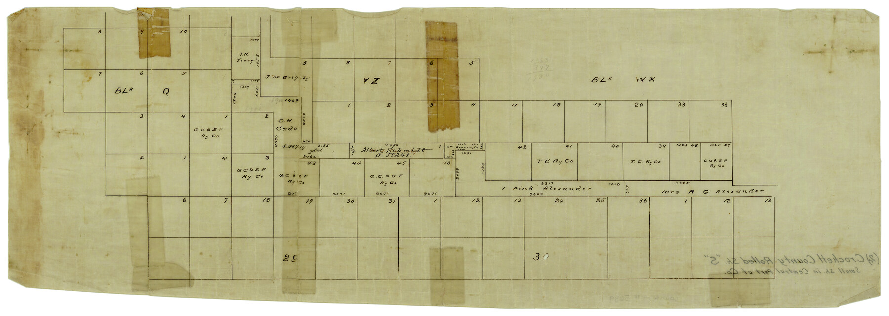
Crockett County Rolled Sketch S
[Small sketch in central part of county showing Blocks Q, YZ, WX, 29 & 30]
-
Map/Doc
5639
-
Collection
General Map Collection
-
Counties
Crockett
-
Subjects
Surveying Rolled Sketch
-
Height x Width
8.3 x 21.2 inches
21.1 x 53.9 cm
-
Medium
paper, manuscript
Part of: General Map Collection
San Augustine County Working Sketch 22

Print $20.00
- Digital $50.00
San Augustine County Working Sketch 22
1974
Size 16.1 x 29.0 inches
Map/Doc 63710
Flight Mission No. CRC-3R, Frame 43, Chambers County

Print $20.00
- Digital $50.00
Flight Mission No. CRC-3R, Frame 43, Chambers County
1956
Size 18.5 x 22.3 inches
Map/Doc 84816
Plan of the City of Austin

Print $40.00
- Digital $50.00
Plan of the City of Austin
1840
Size 54.0 x 38.9 inches
Map/Doc 2176
Liberty County Working Sketch 62

Print $20.00
- Digital $50.00
Liberty County Working Sketch 62
1969
Size 22.1 x 28.3 inches
Map/Doc 70522
Andrews County

Print $40.00
- Digital $50.00
Andrews County
1951
Size 42.7 x 54.4 inches
Map/Doc 73067
Johnson County Working Sketch 11

Print $20.00
- Digital $50.00
Johnson County Working Sketch 11
1953
Size 28.7 x 22.4 inches
Map/Doc 66624
Pecos County Rolled Sketch 123

Print $20.00
- Digital $50.00
Pecos County Rolled Sketch 123
Size 20.3 x 25.4 inches
Map/Doc 7264
Flight Mission No. CRC-3R, Frame 95, Chambers County

Print $20.00
- Digital $50.00
Flight Mission No. CRC-3R, Frame 95, Chambers County
1956
Size 18.6 x 22.4 inches
Map/Doc 84833
Sutton County

Print $40.00
- Digital $50.00
Sutton County
1898
Size 39.1 x 56.5 inches
Map/Doc 63051
Mills County Working Sketch 28

Print $40.00
- Digital $50.00
Mills County Working Sketch 28
2006
Size 42.0 x 67.4 inches
Map/Doc 85385
Flight Mission No. DAG-22K, Frame 74, Matagorda County

Print $20.00
- Digital $50.00
Flight Mission No. DAG-22K, Frame 74, Matagorda County
1953
Size 18.8 x 22.5 inches
Map/Doc 86461
Galveston Harbor, Texas

Print $20.00
- Digital $50.00
Galveston Harbor, Texas
1882
Size 15.0 x 19.5 inches
Map/Doc 97281
You may also like
Map of Texas-Mexican Railway Lands in El Paso County, Texas

Print $3.00
- Digital $50.00
Map of Texas-Mexican Railway Lands in El Paso County, Texas
1907
Size 13.7 x 10.8 inches
Map/Doc 91134
A New Map of Nebraska, Kansas, New Mexico and Indian Territories

Print $20.00
- Digital $50.00
A New Map of Nebraska, Kansas, New Mexico and Indian Territories
Size 18.6 x 15.2 inches
Map/Doc 93985
McMullen County Sketch File 5

Print $4.00
- Digital $50.00
McMullen County Sketch File 5
1854
Size 8.7 x 8.3 inches
Map/Doc 31343
Medina County Rolled Sketch 15

Print $20.00
- Digital $50.00
Medina County Rolled Sketch 15
1980
Size 25.2 x 20.3 inches
Map/Doc 6749
Llano County Boundary File 1a

Print $44.00
- Digital $50.00
Llano County Boundary File 1a
Size 13.2 x 8.1 inches
Map/Doc 56430
Bandera County Rolled Sketch 10

Print $20.00
- Digital $50.00
Bandera County Rolled Sketch 10
1998
Size 35.4 x 38.1 inches
Map/Doc 8440
Flight Mission No. DQN-1K, Frame 51, Calhoun County

Print $20.00
- Digital $50.00
Flight Mission No. DQN-1K, Frame 51, Calhoun County
1953
Size 18.6 x 22.3 inches
Map/Doc 84151
[Sketch of Randall County]
![91757, [Sketch of Randall County], Twichell Survey Records](https://historictexasmaps.com/wmedia_w700/maps/91757-1.tif.jpg)
Print $20.00
- Digital $50.00
[Sketch of Randall County]
Size 21.4 x 18.5 inches
Map/Doc 91757
Railroad Track Map, H&TCRRCo., Falls County, Texas

Print $4.00
- Digital $50.00
Railroad Track Map, H&TCRRCo., Falls County, Texas
1918
Size 11.7 x 18.5 inches
Map/Doc 62839
Angelina County

Print $40.00
- Digital $50.00
Angelina County
1945
Size 38.9 x 49.3 inches
Map/Doc 77200
El Paso County Sketch File 12

Print $22.00
- Digital $50.00
El Paso County Sketch File 12
1887
Size 8.1 x 5.9 inches
Map/Doc 22004
Real County Working Sketch 3

Print $20.00
- Digital $50.00
Real County Working Sketch 3
Size 35.0 x 24.9 inches
Map/Doc 71895