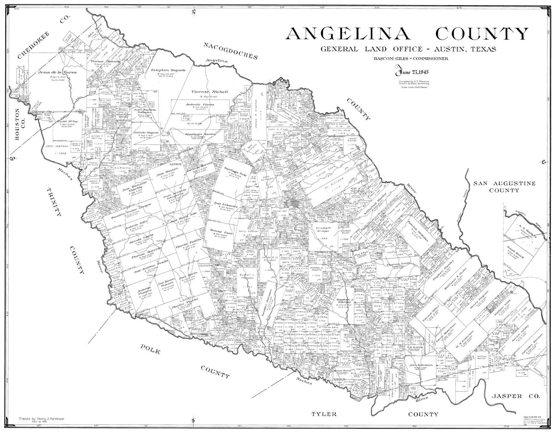
Angelina County
-
Map/Doc
77200
-
Collection
General Map Collection
-
Object Dates
1945/6/27 (Creation Date)
-
People and Organizations
General Land Office (Publisher)
Eltea Armstrong (Draftsman)
Bascom Giles (GLO Commissioner)
G.C. Morriss (Compiler)
-
Counties
Angelina
-
Subjects
County
-
Height x Width
38.9 x 49.3 inches
98.8 x 125.2 cm
Part of: General Map Collection
Hutchinson County Sketch File 5

Print $60.00
- Digital $50.00
Hutchinson County Sketch File 5
Size 15.1 x 62.7 inches
Map/Doc 10498
1883 Map of the Texas & Pacific R-Y Reserve

Print $40.00
- Digital $50.00
1883 Map of the Texas & Pacific R-Y Reserve
1883
Size 42.2 x 86.4 inches
Map/Doc 2236
Jeff Davis County Sketch File 45

Print $10.00
- Digital $50.00
Jeff Davis County Sketch File 45
1890
Size 14.0 x 8.5 inches
Map/Doc 28075
Sherman County Sketch File C

Print $54.00
- Digital $50.00
Sherman County Sketch File C
1918
Size 11.4 x 8.8 inches
Map/Doc 36694
Grayson County Sketch File 21

Print $14.00
- Digital $50.00
Grayson County Sketch File 21
Size 7.7 x 17.8 inches
Map/Doc 24495
Jasper County Sketch File 5

Print $4.00
- Digital $50.00
Jasper County Sketch File 5
Size 8.4 x 12.1 inches
Map/Doc 27770
Rusk County Working Sketch 9

Print $20.00
- Digital $50.00
Rusk County Working Sketch 9
1981
Size 28.3 x 32.3 inches
Map/Doc 63644
Culberson County Sketch File 13

Print $16.00
- Digital $50.00
Culberson County Sketch File 13
1912
Size 11.2 x 8.7 inches
Map/Doc 20146
Stonewall County Boundary File 4a

Print $18.00
- Digital $50.00
Stonewall County Boundary File 4a
Size 14.2 x 8.8 inches
Map/Doc 58984
Burnet County Working Sketch 1

Print $20.00
- Digital $50.00
Burnet County Working Sketch 1
1916
Size 22.4 x 31.9 inches
Map/Doc 67844
Arlington Street Map & Guide

Digital $50.00
Arlington Street Map & Guide
Size 35.4 x 23.0 inches
Map/Doc 94437
Wilbarger County Rolled Sketch 10

Print $20.00
- Digital $50.00
Wilbarger County Rolled Sketch 10
1983
Size 37.6 x 23.8 inches
Map/Doc 8259
You may also like
Lavaca County Working Sketch 7

Print $20.00
- Digital $50.00
Lavaca County Working Sketch 7
1945
Size 23.6 x 26.2 inches
Map/Doc 70360
Wood County Boundary File 5

Print $20.00
- Digital $50.00
Wood County Boundary File 5
Size 10.8 x 8.1 inches
Map/Doc 60170
[Aransas Wildlife Refuge]
![2081, [Aransas Wildlife Refuge], General Map Collection](https://historictexasmaps.com/wmedia_w700/maps/2081.tif.jpg)
Print $40.00
- Digital $50.00
[Aransas Wildlife Refuge]
1965
Size 55.6 x 42.9 inches
Map/Doc 2081
Hudspeth County Rolled Sketch 69

Print $20.00
- Digital $50.00
Hudspeth County Rolled Sketch 69
1973
Size 12.3 x 19.8 inches
Map/Doc 7719
Map of Chicago, Rock Island & Texas Railroad

Print $40.00
- Digital $50.00
Map of Chicago, Rock Island & Texas Railroad
1892
Size 23.9 x 122.0 inches
Map/Doc 64442
Harris County Working Sketch 123

Print $20.00
- Digital $50.00
Harris County Working Sketch 123
1993
Size 19.5 x 17.0 inches
Map/Doc 66015
Frio County Rolled Sketch 17

Print $20.00
- Digital $50.00
Frio County Rolled Sketch 17
1953
Size 32.4 x 44.5 inches
Map/Doc 8907
Rusk County Working Sketch 19

Print $20.00
- Digital $50.00
Rusk County Working Sketch 19
1955
Size 19.0 x 18.2 inches
Map/Doc 63654
Cooke County Sketch File 33

Print $44.00
- Digital $50.00
Cooke County Sketch File 33
1873
Size 13.4 x 26.5 inches
Map/Doc 11174

Jeff Davis County Sketch File 13

Print $14.00
- Digital $50.00
Jeff Davis County Sketch File 13
1889
Size 13.9 x 8.5 inches
Map/Doc 27941
Flight Mission No. CRC-2R, Frame 199, Chambers County

Print $20.00
- Digital $50.00
Flight Mission No. CRC-2R, Frame 199, Chambers County
1956
Size 18.6 x 22.4 inches
Map/Doc 84777