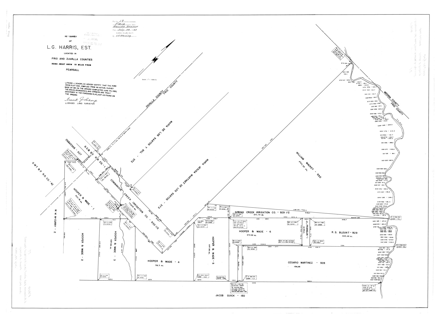
Frio County Rolled Sketch 17
Resurvey of L.G. Harris, Est. located in Frio and Zavala Counties
-
Map/Doc
8907
-
Collection
General Map Collection
-
Object Dates
1953/6/24 (Creation Date)
1953/7/28 (File Date)
-
People and Organizations
Frank J. Schorp (Surveyor/Engineer)
-
Counties
Frio Zavala
-
Subjects
Surveying Rolled Sketch
-
Height x Width
32.4 x 44.5 inches
82.3 x 113.0 cm
-
Scale
1" = 400 varas
Part of: General Map Collection
Upton County Sketch File 35

Print $14.00
- Digital $50.00
Upton County Sketch File 35
1942
Size 11.4 x 8.8 inches
Map/Doc 38886
Chambers County Sketch File X

Print $4.00
- Digital $50.00
Chambers County Sketch File X
1936
Size 11.1 x 8.7 inches
Map/Doc 17598

Presidio County Rolled Sketch 145

Print $20.00
- Digital $50.00
Presidio County Rolled Sketch 145
2012
Size 36.6 x 24.5 inches
Map/Doc 93380
Lampasas County Sketch File 6

Print $4.00
- Digital $50.00
Lampasas County Sketch File 6
1871
Size 8.0 x 6.8 inches
Map/Doc 29400
Ochiltree County

Print $20.00
- Digital $50.00
Ochiltree County
1908
Size 40.9 x 37.1 inches
Map/Doc 16782

Van Zandt County Working Sketch 20

Print $20.00
- Digital $50.00
Van Zandt County Working Sketch 20
1992
Size 30.4 x 34.7 inches
Map/Doc 72270
Upton County Rolled Sketch 24

Print $20.00
- Digital $50.00
Upton County Rolled Sketch 24
1886
Size 17.3 x 43.5 inches
Map/Doc 10043


Cass County Sketch File 11

Print $6.00
- Digital $50.00
Cass County Sketch File 11
Size 10.4 x 14.4 inches
Map/Doc 17412
You may also like
Flight Mission No. DIX-10P, Frame 178, Aransas County

Print $20.00
- Digital $50.00
Flight Mission No. DIX-10P, Frame 178, Aransas County
1956
Size 18.5 x 22.2 inches
Map/Doc 83968
Menard County Rolled Sketch 2A

Print $20.00
- Digital $50.00
Menard County Rolled Sketch 2A
1905
Size 23.3 x 18.5 inches
Map/Doc 6753
[Three Positions Concluded, Exhibit F]
![91371, [Three Positions Concluded, Exhibit F], Twichell Survey Records](https://historictexasmaps.com/wmedia_w700/maps/91371-1.tif.jpg)
Print $20.00
- Digital $50.00
[Three Positions Concluded, Exhibit F]
Size 26.0 x 16.4 inches
Map/Doc 91371
Coleman County Sketch File 29

Print $40.00
- Digital $50.00
Coleman County Sketch File 29
1873
Size 16.9 x 12.9 inches
Map/Doc 18718
Coast Chart No. 210 Aransas Pass and Corpus Christi Bay with the coast to latitude 27° 12' Texas

Print $20.00
- Digital $50.00
Coast Chart No. 210 Aransas Pass and Corpus Christi Bay with the coast to latitude 27° 12' Texas
1887
Size 26.9 x 18.3 inches
Map/Doc 72811
Brazoria County Working Sketch 5

Print $20.00
- Digital $50.00
Brazoria County Working Sketch 5
1921
Size 15.1 x 17.1 inches
Map/Doc 67490
Mitchell County Working Sketch Graphic Index

Print $20.00
- Digital $50.00
Mitchell County Working Sketch Graphic Index
1971
Size 41.0 x 34.4 inches
Map/Doc 76644
Starr County Rolled Sketch 46B

Print $20.00
- Digital $50.00
Starr County Rolled Sketch 46B
1986
Size 17.9 x 34.5 inches
Map/Doc 7838
Flight Mission No. BRA-3M, Frame 129, Jefferson County

Print $20.00
- Digital $50.00
Flight Mission No. BRA-3M, Frame 129, Jefferson County
1953
Size 18.5 x 22.3 inches
Map/Doc 85403
Plat in Pecos County, Texas

Print $40.00
- Digital $50.00
Plat in Pecos County, Texas
1927
Size 57.9 x 37.0 inches
Map/Doc 89836
Brewster County Rolled Sketch 77

Print $20.00
- Digital $50.00
Brewster County Rolled Sketch 77
1944
Size 24.4 x 32.0 inches
Map/Doc 5242
Calhoun County Sketch File 1

Print $7.00
- Digital $50.00
Calhoun County Sketch File 1
1855
Size 17.1 x 11.0 inches
Map/Doc 11031