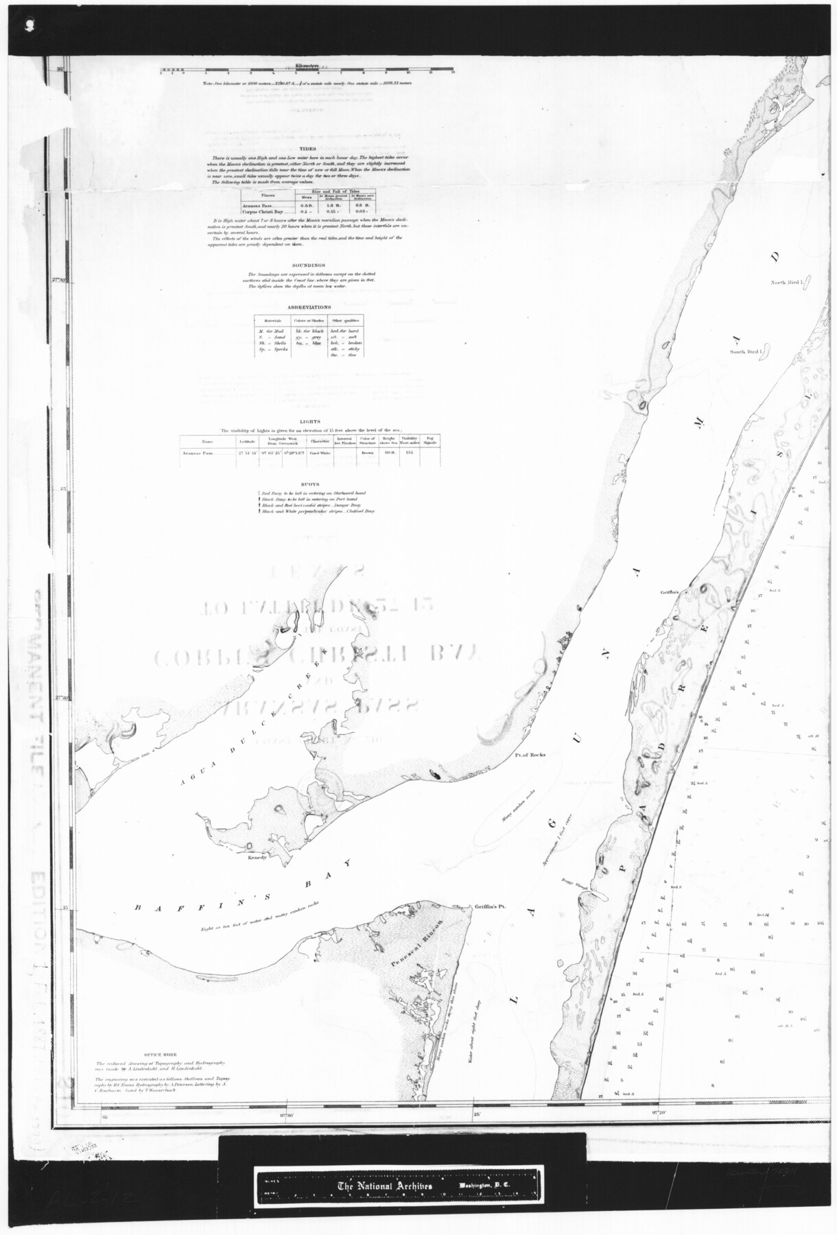
Coast Chart No. 210 Aransas Pass and Corpus Christi Bay with the coast to latitude 27° 12' Texas
RL-2-12
-
Map/Doc
72811
-
Collection
General Map Collection
-
Object Dates
1887 (Creation Date)
-
People and Organizations
[U. S. Coast and Geodetic Survey] (Publisher)
-
Counties
Nueces
-
Subjects
Nautical Charts
-
Height x Width
26.9 x 18.3 inches
68.3 x 46.5 cm
-
Comments
B/W photostat copy from National Archives in multiple pieces.
Part of: General Map Collection
Flight Mission No. CUG-1P, Frame 171, Kleberg County

Print $20.00
- Digital $50.00
Flight Mission No. CUG-1P, Frame 171, Kleberg County
1956
Size 18.5 x 22.1 inches
Map/Doc 86178
Caldwell County Sketch File 4a

Print $8.00
- Digital $50.00
Caldwell County Sketch File 4a
1898
Size 11.2 x 8.8 inches
Map/Doc 35835
Presidio County Working Sketch 115

Print $20.00
- Digital $50.00
Presidio County Working Sketch 115
1981
Size 28.7 x 26.7 inches
Map/Doc 71792
Val Verde County Rolled Sketch 69A

Print $40.00
- Digital $50.00
Val Verde County Rolled Sketch 69A
1942
Size 11.0 x 139.1 inches
Map/Doc 10086
Kleberg County Rolled Sketch 10-26

Print $20.00
- Digital $50.00
Kleberg County Rolled Sketch 10-26
1951
Size 36.6 x 35.5 inches
Map/Doc 9362
Brewster County Rolled Sketch 77

Print $20.00
- Digital $50.00
Brewster County Rolled Sketch 77
1944
Size 24.4 x 32.0 inches
Map/Doc 5242
![94197, New Mexico [Verso], General Map Collection](https://historictexasmaps.com/wmedia_w700/maps/94197.tif.jpg)
Navigation Maps of Gulf Intracoastal Waterway, Port Arthur to Brownsville, Texas

Print $4.00
- Digital $50.00
Navigation Maps of Gulf Intracoastal Waterway, Port Arthur to Brownsville, Texas
1951
Size 16.6 x 21.6 inches
Map/Doc 65429
Amistad International Reservoir on Rio Grande 62

Print $20.00
- Digital $50.00
Amistad International Reservoir on Rio Grande 62
1949
Size 28.2 x 39.6 inches
Map/Doc 73347
Presidio County Rolled Sketch 40

Print $20.00
- Digital $50.00
Presidio County Rolled Sketch 40
1907
Size 16.5 x 21.5 inches
Map/Doc 7337
Hartley County Sketch File 6

Print $20.00
- Digital $50.00
Hartley County Sketch File 6
Size 30.5 x 25.6 inches
Map/Doc 11698
Jefferson County Rolled Sketch 19

Print $90.00
- Digital $50.00
Jefferson County Rolled Sketch 19
1931
Size 19.1 x 72.7 inches
Map/Doc 9283
You may also like
Medina County Rolled Sketch 18

Print $20.00
- Digital $50.00
Medina County Rolled Sketch 18
Size 33.4 x 25.3 inches
Map/Doc 6751
Report of Construction re: MA 46948, H. C. Henson

Print $2.00
- Digital $50.00
Report of Construction re: MA 46948, H. C. Henson
1954
Size 11.1 x 8.9 inches
Map/Doc 62571
[Sketch for M-12871 to M-13240 - Presidio County]
![65650, [Sketch for M-12871 to M-13240 - Presidio County], General Map Collection](https://historictexasmaps.com/wmedia_w700/maps/65650.tif.jpg)
Print $20.00
- Digital $50.00
[Sketch for M-12871 to M-13240 - Presidio County]
1927
Size 30.6 x 33.0 inches
Map/Doc 65650
Tarrant County Sketch File 15

Print $4.00
- Digital $50.00
Tarrant County Sketch File 15
1859
Size 13.2 x 8.1 inches
Map/Doc 37708
Tyler County Sketch File 31

Print $10.00
- Digital $50.00
Tyler County Sketch File 31
1941
Size 14.3 x 9.0 inches
Map/Doc 38723
Refugio County Boundary File 3

Print $4.00
- Digital $50.00
Refugio County Boundary File 3
Size 14.0 x 8.7 inches
Map/Doc 58244
Kerr County Working Sketch Graphic Index

Print $40.00
- Digital $50.00
Kerr County Working Sketch Graphic Index
1923
Size 40.4 x 55.9 inches
Map/Doc 76605
Hockley County Sketch File 3

Print $20.00
- Digital $50.00
Hockley County Sketch File 3
Size 43.1 x 35.4 inches
Map/Doc 10490
General Highway Map, Polk County, Texas

Print $20.00
General Highway Map, Polk County, Texas
1940
Size 24.6 x 18.5 inches
Map/Doc 79219
Hamilton County Working Sketch 14

Print $20.00
- Digital $50.00
Hamilton County Working Sketch 14
1949
Size 30.1 x 35.4 inches
Map/Doc 63352
Resurvey of Block K-3

Print $20.00
- Digital $50.00
Resurvey of Block K-3
1913
Size 17.0 x 19.0 inches
Map/Doc 90540
Palo Pinto County Working Sketch 4

Print $20.00
- Digital $50.00
Palo Pinto County Working Sketch 4
1913
Map/Doc 71387