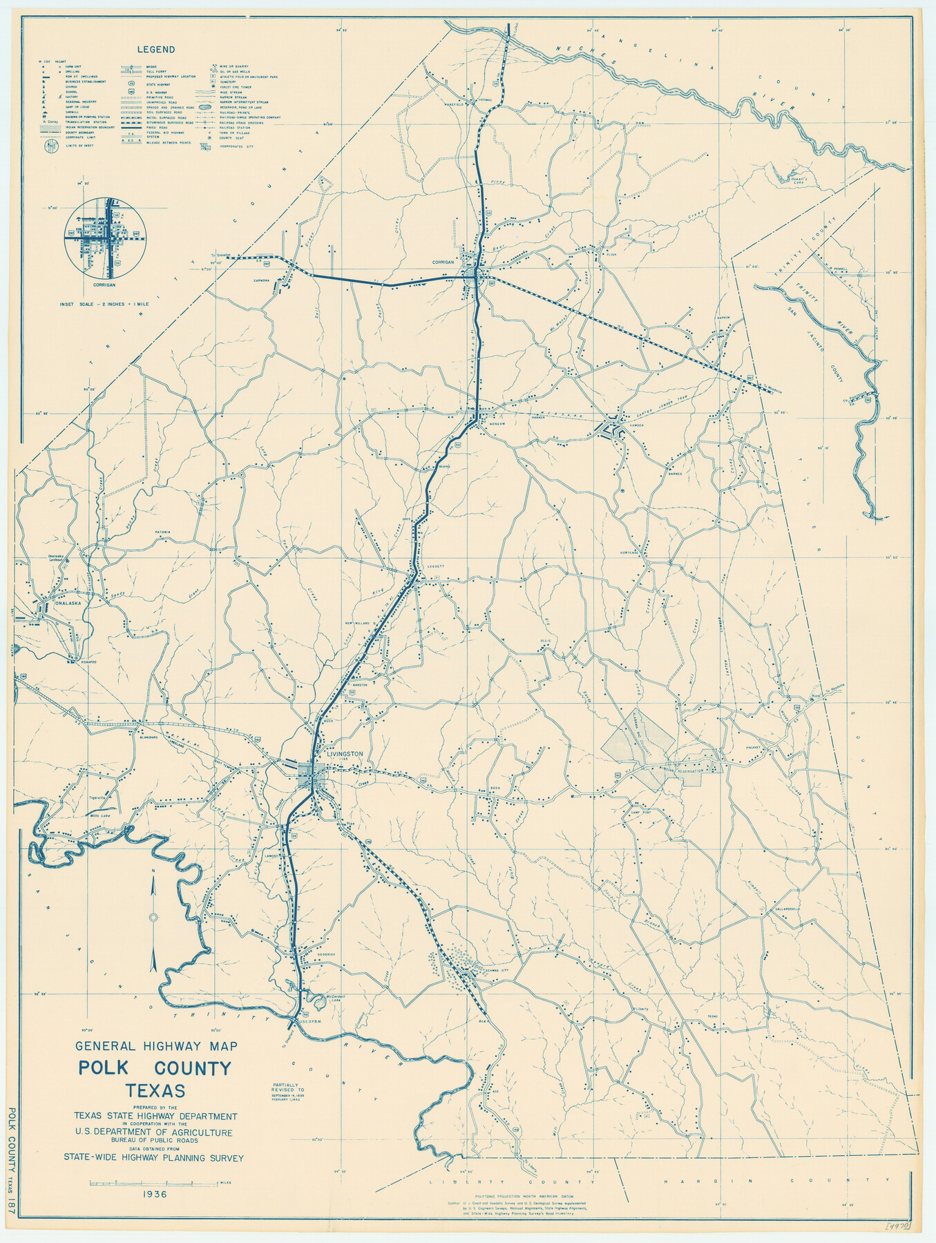
General Highway Map, Polk County, Texas
-
Map/Doc
79219
-
Collection
Texas State Library and Archives
-
Object Dates
1940 (Creation Date)
-
People and Organizations
Texas State Highway Department (Publisher)
-
Counties
Polk
-
Subjects
County
-
Height x Width
24.6 x 18.5 inches
62.5 x 47.0 cm
-
Comments
Prints available courtesy of the Texas State Library and Archives.
More info can be found here: TSLAC Map 04970
Part of: Texas State Library and Archives
Map of the United States of America with its territories and districts including also a part of upper and lower Canada and Mexico

Print $20.00
Map of the United States of America with its territories and districts including also a part of upper and lower Canada and Mexico
1835
Size 30.3 x 43.2 inches
Map/Doc 79728
New City Map of Laredo, Texas

Print $20.00
New City Map of Laredo, Texas
1930
Size 21.7 x 11.3 inches
Map/Doc 76277
General Highway Map, Kaufman County, Texas

Print $20.00
General Highway Map, Kaufman County, Texas
1961
Size 24.9 x 18.1 inches
Map/Doc 79548
General Highway Map, Cooke County, Texas

Print $20.00
General Highway Map, Cooke County, Texas
1940
Size 25.2 x 18.3 inches
Map/Doc 79058
Map of the Republic of Texas and the Adjacent Territories, Indicating the Grants of Land Conceded under the Empresario System of Mexico

Print $20.00
Map of the Republic of Texas and the Adjacent Territories, Indicating the Grants of Land Conceded under the Empresario System of Mexico
1841
Size 13.4 x 16.7 inches
Map/Doc 76244
General Highway Map, Bowie County, Texas

Print $20.00
General Highway Map, Bowie County, Texas
1961
Size 18.2 x 25.0 inches
Map/Doc 79380
General Highway Map. Detail of Cities and Towns in Hale County, Texas [Plainview and vicinity]
![79109, General Highway Map. Detail of Cities and Towns in Hale County, Texas [Plainview and vicinity], Texas State Library and Archives](https://historictexasmaps.com/wmedia_w700/maps/79109.tif.jpg)
Print $20.00
General Highway Map. Detail of Cities and Towns in Hale County, Texas [Plainview and vicinity]
1940
Size 25.0 x 18.5 inches
Map/Doc 79109
General Highway Map, Erath County, Texas

Print $20.00
General Highway Map, Erath County, Texas
1940
Size 24.7 x 18.4 inches
Map/Doc 79086
General Highway Map, Kleberg County, Texas

Print $20.00
General Highway Map, Kleberg County, Texas
1961
Size 24.8 x 18.3 inches
Map/Doc 79558
General Highway Map, Liberty County, Texas

Print $20.00
General Highway Map, Liberty County, Texas
1940
Size 24.6 x 18.3 inches
Map/Doc 79173
General Highway Map, Maverick County, Zavala County, Texas

Print $20.00
General Highway Map, Maverick County, Zavala County, Texas
1940
Size 18.6 x 24.7 inches
Map/Doc 79189
General Highway Map, Crosby County, Texas

Print $20.00
General Highway Map, Crosby County, Texas
1940
Size 18.3 x 25.1 inches
Map/Doc 79063
You may also like
Maps & Lists Showing Prison Lands (Oil & Gas) Leased as of June 1955

Digital $50.00
Maps & Lists Showing Prison Lands (Oil & Gas) Leased as of June 1955
Size 11.4 x 7.1 inches
Map/Doc 62866
Aransas County Boundary File 2

Print $3.00
- Digital $50.00
Aransas County Boundary File 2
Size 12.4 x 10.8 inches
Map/Doc 49781
[Capitol Land Leagues and Blocks M6, 10T, T1, O5 and part of Block B]
![93194, [Capitol Land Leagues and Blocks M6, 10T, T1, O5 and part of Block B], Twichell Survey Records](https://historictexasmaps.com/wmedia_w700/maps/93194-1.tif.jpg)
Print $40.00
- Digital $50.00
[Capitol Land Leagues and Blocks M6, 10T, T1, O5 and part of Block B]
Size 43.7 x 105.6 inches
Map/Doc 93194
Flight Mission No. DAG-21K, Frame 99, Matagorda County

Print $20.00
- Digital $50.00
Flight Mission No. DAG-21K, Frame 99, Matagorda County
1952
Size 17.5 x 16.3 inches
Map/Doc 86428
Terrell County Working Sketch 15

Print $20.00
- Digital $50.00
Terrell County Working Sketch 15
1927
Size 18.7 x 19.8 inches
Map/Doc 62164
Val Verde County Working Sketch 60

Print $20.00
- Digital $50.00
Val Verde County Working Sketch 60
1958
Size 32.1 x 32.4 inches
Map/Doc 72195
No. 2 Chart of Corpus Christi Pass, Texas

Print $20.00
- Digital $50.00
No. 2 Chart of Corpus Christi Pass, Texas
1878
Size 18.3 x 27.4 inches
Map/Doc 73019
Freestone County Working Sketch 32

Print $20.00
- Digital $50.00
Freestone County Working Sketch 32
1997
Size 46.5 x 34.0 inches
Map/Doc 69274
Terrell County Working Sketch 3

Print $20.00
- Digital $50.00
Terrell County Working Sketch 3
1908
Size 20.2 x 25.0 inches
Map/Doc 62151
Flight Mission No. DQN-1K, Frame 107, Calhoun County

Print $20.00
- Digital $50.00
Flight Mission No. DQN-1K, Frame 107, Calhoun County
1953
Size 18.4 x 22.3 inches
Map/Doc 84174
Trinity County Sketch File 19

Print $20.00
- Digital $50.00
Trinity County Sketch File 19
Size 16.6 x 16.7 inches
Map/Doc 12484
