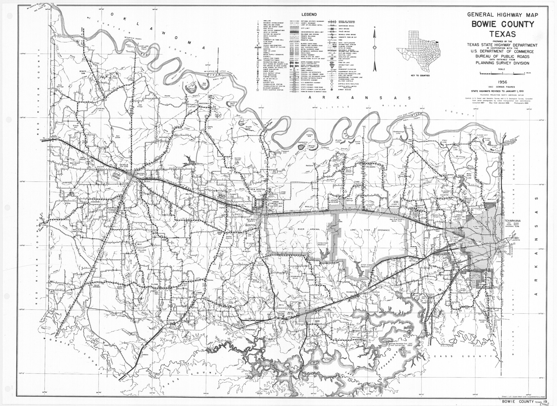
General Highway Map, Bowie County, Texas
-
Map/Doc
79380
-
Collection
Texas State Library and Archives
-
Object Dates
1961 (Creation Date)
-
People and Organizations
Texas State Highway Department (Publisher)
-
Counties
Bowie
-
Subjects
County
-
Height x Width
18.2 x 25.0 inches
46.2 x 63.5 cm
-
Comments
Prints available courtesy of the Texas State Library and Archives.
More info can be found here: TSLAC Map 05061
Part of: Texas State Library and Archives
Map of the Country Upon the Brazos and Big Wichita Rivers Embracing the Lands appropriated by the State of Texas for the Use of the Indians

Print $20.00
Map of the Country Upon the Brazos and Big Wichita Rivers Embracing the Lands appropriated by the State of Texas for the Use of the Indians
1854
Size 28.8 x 32.3 inches
Map/Doc 76284
General Highway Map, Kinney County, Uvalde County, Texas

Print $20.00
General Highway Map, Kinney County, Uvalde County, Texas
1961
Size 18.2 x 24.6 inches
Map/Doc 79556
General Highway Map, Brazos County, Texas

Print $20.00
General Highway Map, Brazos County, Texas
1961
Size 24.9 x 18.3 inches
Map/Doc 79384
General Highway Map, Tom Green County, Texas

Print $20.00
General Highway Map, Tom Green County, Texas
1940
Size 25.0 x 18.5 inches
Map/Doc 79260
General Highway Map, Swisher County, Texas

Print $20.00
General Highway Map, Swisher County, Texas
1961
Size 18.3 x 25.0 inches
Map/Doc 79663
Reconnoissance of Sabine Pass

Print $20.00
Reconnoissance of Sabine Pass
1853
Size 12.4 x 10.3 inches
Map/Doc 76281
General Highway Map, Scurry County, Texas

Print $20.00
General Highway Map, Scurry County, Texas
1961
Size 18.1 x 24.8 inches
Map/Doc 79650
General Highway Map, Jeff Davis County, Texas

Print $20.00
General Highway Map, Jeff Davis County, Texas
1940
Size 18.6 x 24.8 inches
Map/Doc 79143
General Highway Map, Milam County, Texas

Print $20.00
General Highway Map, Milam County, Texas
1940
Size 18.5 x 24.8 inches
Map/Doc 79198
General Highway Map. Detail of Cities and Towns in Dallas County, Texas [Dallas and vicinity]
![79431, General Highway Map. Detail of Cities and Towns in Dallas County, Texas [Dallas and vicinity], Texas State Library and Archives](https://historictexasmaps.com/wmedia_w700/maps/79431.tif.jpg)
Print $20.00
General Highway Map. Detail of Cities and Towns in Dallas County, Texas [Dallas and vicinity]
1961
Size 18.1 x 24.4 inches
Map/Doc 79431
Pressler's Map of the State of Texas

Print $40.00
Pressler's Map of the State of Texas
1858
Size 48.0 x 52.5 inches
Map/Doc 76232
General Highway Map, Brewster County, Texas

Print $20.00
General Highway Map, Brewster County, Texas
1940
Size 18.5 x 25.2 inches
Map/Doc 79027
You may also like
Map of Presidio County, Texas

Print $40.00
- Digital $50.00
Map of Presidio County, Texas
Size 42.7 x 82.1 inches
Map/Doc 82050
Burnet County Rolled Sketch 4

Print $20.00
- Digital $50.00
Burnet County Rolled Sketch 4
1949
Size 31.9 x 17.5 inches
Map/Doc 5356
The Oil and Gas Journal's Oil Map of Texas

Print $20.00
- Digital $50.00
The Oil and Gas Journal's Oil Map of Texas
1938
Size 38.3 x 39.4 inches
Map/Doc 96970
Upton County Working Sketch 49B

Print $20.00
- Digital $50.00
Upton County Working Sketch 49B
1979
Size 19.0 x 32.0 inches
Map/Doc 69546
Kenedy County Aerial Photograph Index Sheet 6

Print $20.00
- Digital $50.00
Kenedy County Aerial Photograph Index Sheet 6
1943
Size 23.4 x 18.4 inches
Map/Doc 83716

Flight Mission No. BRA-6M, Frame 98, Jefferson County

Print $20.00
- Digital $50.00
Flight Mission No. BRA-6M, Frame 98, Jefferson County
1953
Size 18.5 x 22.2 inches
Map/Doc 85441
Austin Empresario Colony. November 20, 1827

Print $20.00
Austin Empresario Colony. November 20, 1827
2020
Size 14.7 x 21.7 inches
Map/Doc 95981
[Location, Chicago & Rock Island Railroad Through Tarrant County]
![64343, [Location, Chicago & Rock Island Railroad Through Tarrant County], General Map Collection](https://historictexasmaps.com/wmedia_w700/maps/64343.tif.jpg)
Print $40.00
- Digital $50.00
[Location, Chicago & Rock Island Railroad Through Tarrant County]
Size 25.9 x 115.5 inches
Map/Doc 64343
Smith County Working Sketch 13

Print $20.00
- Digital $50.00
Smith County Working Sketch 13
1962
Size 36.8 x 27.4 inches
Map/Doc 63898
Montgomery County Sketch File 2

Print $8.00
- Digital $50.00
Montgomery County Sketch File 2
1846
Size 12.7 x 8.0 inches
Map/Doc 31764
Coleman County Rolled Sketch 6

Print $20.00
- Digital $50.00
Coleman County Rolled Sketch 6
Size 20.9 x 14.4 inches
Map/Doc 5529