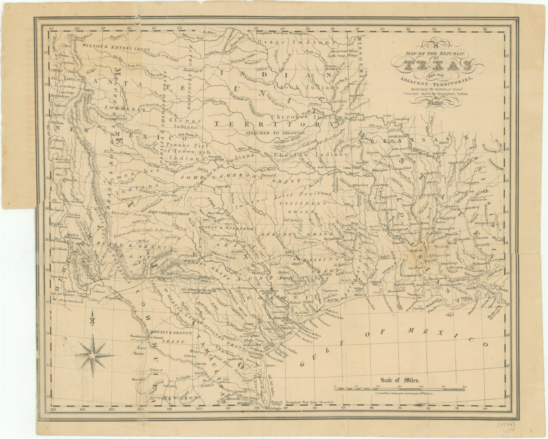
Map of the Republic of Texas and the Adjacent Territories, Indicating the Grants of Land Conceded under the Empresario System of Mexico
-
Map/Doc
76244
-
Collection
Texas State Library and Archives
-
Object Dates
1841 (Creation Date)
-
People and Organizations
C. F. Cheffins (Printer)
-
Subjects
Republic of Texas
-
Height x Width
13.4 x 16.7 inches
34.0 x 42.4 cm
-
Comments
Prints available courtesy of the Texas State Library and Archives.
More info can be found here: TSLAC Map 01594
Part of: Texas State Library and Archives
General Highway Map, Jackson County, Texas

Print $20.00
General Highway Map, Jackson County, Texas
1961
Size 18.2 x 24.7 inches
Map/Doc 79533
General Highway Map, Grimes County, Texas

Print $20.00
General Highway Map, Grimes County, Texas
1961
Size 24.8 x 18.1 inches
Map/Doc 79490
General Highway Map, Kenedy County, Texas

Print $20.00
General Highway Map, Kenedy County, Texas
1940
Size 18.4 x 24.9 inches
Map/Doc 79155
General Highway Map, Rusk County, Texas

Print $20.00
General Highway Map, Rusk County, Texas
1961
Size 24.9 x 18.2 inches
Map/Doc 79643
General Highway Map, Hamilton County, Texas

Print $20.00
General Highway Map, Hamilton County, Texas
1940
Size 18.4 x 24.9 inches
Map/Doc 79111

Rand McNally Standard Map of Texas

Print $20.00
Rand McNally Standard Map of Texas
1923
Size 27.7 x 40.3 inches
Map/Doc 76259
General Highway Map, Hill County, Texas

Print $20.00
General Highway Map, Hill County, Texas
1961
Size 24.5 x 18.2 inches
Map/Doc 79520
Coast Chart No. 107, Oyster Bay to Matagorda Bay, Texas

Print $20.00
Coast Chart No. 107, Oyster Bay to Matagorda Bay, Texas
1858
Size 32.8 x 41.0 inches
Map/Doc 79306
General Highway Map, Shackelford County, Texas

Print $20.00
General Highway Map, Shackelford County, Texas
1961
Size 18.1 x 24.8 inches
Map/Doc 79651
General Highway Map. Detail of Cities and Towns in Bowie County, Texas

Print $20.00
General Highway Map. Detail of Cities and Towns in Bowie County, Texas
1961
Size 18.0 x 24.8 inches
Map/Doc 79381
Map of the Texas and Pacific Railway and Connections

Print $20.00
Map of the Texas and Pacific Railway and Connections
1897
Size 19.3 x 24.4 inches
Map/Doc 79328
You may also like
Culberson County Working Sketch 69

Print $40.00
- Digital $50.00
Culberson County Working Sketch 69
1975
Size 49.4 x 32.2 inches
Map/Doc 68523
Crockett County Rolled Sketch FFF-11

Print $20.00
- Digital $50.00
Crockett County Rolled Sketch FFF-11
1937
Size 31.9 x 17.0 inches
Map/Doc 5637
[Sections 77-114, Block 47 and part of G. & M. Blocks 2 and 3]
![91827, [Sections 77-114, Block 47 and part of G. & M. Blocks 2 and 3], Twichell Survey Records](https://historictexasmaps.com/wmedia_w700/maps/91827-1.tif.jpg)
Print $20.00
- Digital $50.00
[Sections 77-114, Block 47 and part of G. & M. Blocks 2 and 3]
Size 38.1 x 19.8 inches
Map/Doc 91827
El Paso County Working Sketch 43

Print $20.00
- Digital $50.00
El Paso County Working Sketch 43
Size 22.1 x 26.1 inches
Map/Doc 69065
Edwards County Working Sketch 120

Print $40.00
- Digital $50.00
Edwards County Working Sketch 120
1975
Size 25.0 x 48.9 inches
Map/Doc 68996
Upshur County Sketch File 14

Print $10.00
- Digital $50.00
Upshur County Sketch File 14
1936
Size 11.4 x 8.8 inches
Map/Doc 38757
Chambers County Working Sketch 16

Print $20.00
- Digital $50.00
Chambers County Working Sketch 16
1961
Size 32.8 x 30.4 inches
Map/Doc 67999

Wise County Sketch File 26

Print $22.00
- Digital $50.00
Wise County Sketch File 26
1855
Size 8.1 x 14.3 inches
Map/Doc 40574
Flight Mission No. CRK-8P, Frame 105, Refugio County

Print $20.00
- Digital $50.00
Flight Mission No. CRK-8P, Frame 105, Refugio County
1956
Size 18.2 x 22.0 inches
Map/Doc 86966
Flight Mission No. DQN-2K, Frame 90, Calhoun County

Print $20.00
- Digital $50.00
Flight Mission No. DQN-2K, Frame 90, Calhoun County
1953
Size 18.4 x 22.3 inches
Map/Doc 84280
Terrell County Working Sketch 85

Print $20.00
- Digital $50.00
Terrell County Working Sketch 85
1994
Size 31.3 x 42.8 inches
Map/Doc 69609