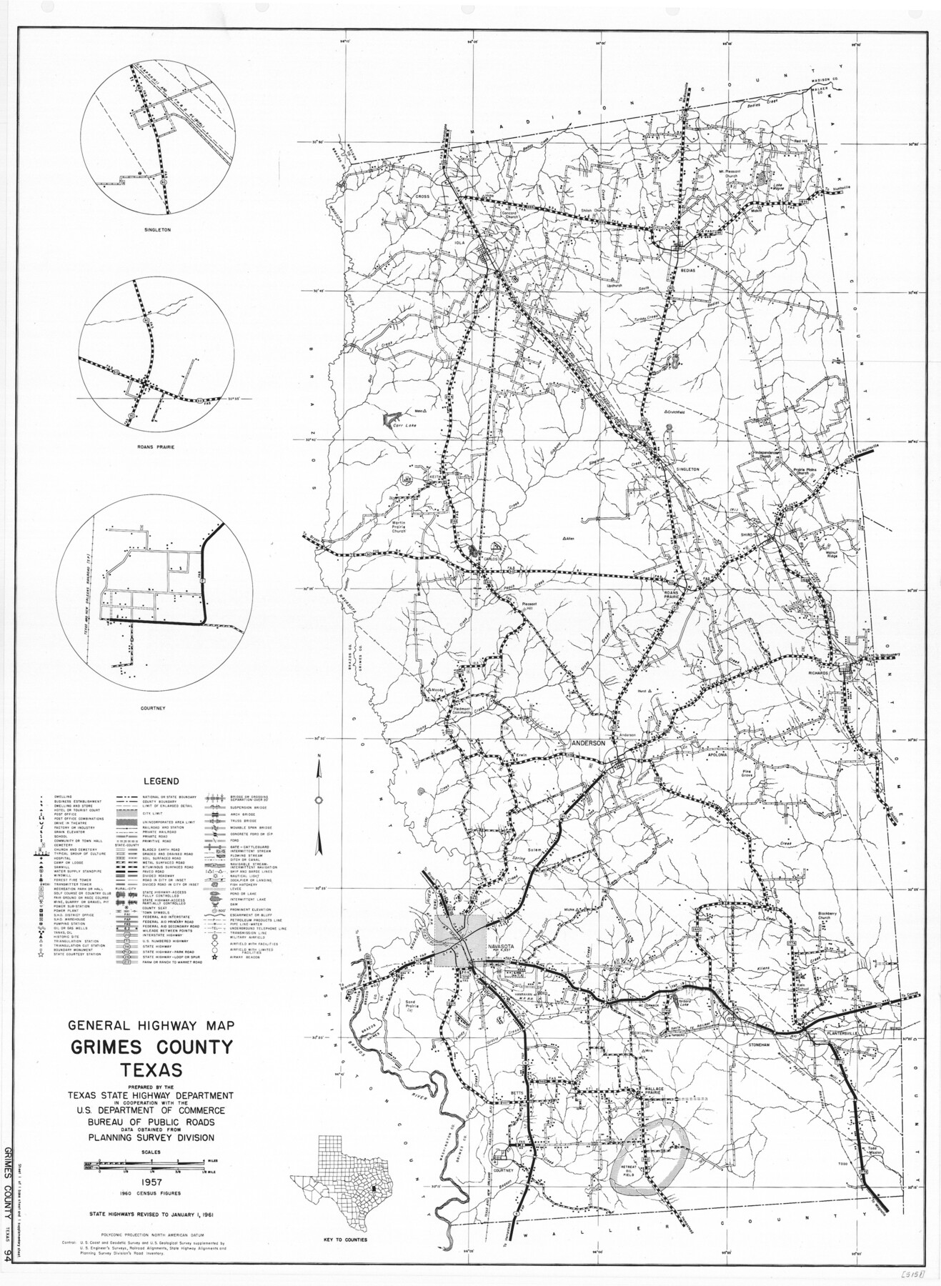
General Highway Map, Grimes County, Texas
-
Map/Doc
79490
-
Collection
Texas State Library and Archives
-
Object Dates
1961 (Creation Date)
-
People and Organizations
Texas State Highway Department (Publisher)
-
Counties
Grimes
-
Subjects
County
-
Height x Width
24.8 x 18.1 inches
63.0 x 46.0 cm
-
Comments
Prints available courtesy of the Texas State Library and Archives.
More info can be found here: TSLAC Map 05151
Part of: Texas State Library and Archives
General Highway Map. Detail of Cities and Towns in Jefferson County, Texas. City Map of Beaumont, Jefferson County, Texas

Print $20.00
General Highway Map. Detail of Cities and Towns in Jefferson County, Texas. City Map of Beaumont, Jefferson County, Texas
1961
Size 25.0 x 18.1 inches
Map/Doc 79539
General Highway Map. Detail of Cities and Towns in El Paso County, Texas [El Paso and vicinity]
![79085, General Highway Map. Detail of Cities and Towns in El Paso County, Texas [El Paso and vicinity], Texas State Library and Archives](https://historictexasmaps.com/wmedia_w700/maps/79085.tif.jpg)
Print $20.00
General Highway Map. Detail of Cities and Towns in El Paso County, Texas [El Paso and vicinity]
1940
Size 24.7 x 18.3 inches
Map/Doc 79085
General Highway Map. Detail of Cities and Towns in Tarrant County, Texas. City Map, Fort Worth and vicinity, Tarrant County, Texas

Print $20.00
General Highway Map. Detail of Cities and Towns in Tarrant County, Texas. City Map, Fort Worth and vicinity, Tarrant County, Texas
1961
Size 18.2 x 25.0 inches
Map/Doc 79670
General Highway Map, Wilbarger County, Texas

Print $20.00
General Highway Map, Wilbarger County, Texas
1961
Size 24.9 x 18.2 inches
Map/Doc 79710
General Highway Map, Shelby County, Texas

Print $20.00
General Highway Map, Shelby County, Texas
1961
Size 18.1 x 24.9 inches
Map/Doc 79652
General Highway Map, Frio County, Texas

Print $20.00
General Highway Map, Frio County, Texas
1961
Size 18.2 x 24.5 inches
Map/Doc 79473
General Highway Map, San Saba County, Texas

Print $20.00
General Highway Map, San Saba County, Texas
1940
Size 18.3 x 24.8 inches
Map/Doc 79238
Mexico and Internal Provinces

Print $20.00
Mexico and Internal Provinces
1822
Size 17.8 x 22.5 inches
Map/Doc 76189
General Highway Map, Rains County, Wood County, Texas

Print $20.00
General Highway Map, Rains County, Wood County, Texas
1939
Size 18.2 x 24.8 inches
Map/Doc 79223
Stanford's Map of the Seat of War in America

Print $40.00
Stanford's Map of the Seat of War in America
1861
Size 52.2 x 45.7 inches
Map/Doc 76231
General Highway Map, Travis County, Texas

Print $20.00
General Highway Map, Travis County, Texas
1940
Size 18.3 x 24.9 inches
Map/Doc 79261
General Highway Map, Wise County, Texas

Print $20.00
General Highway Map, Wise County, Texas
1940
Size 18.2 x 24.8 inches
Map/Doc 79284
You may also like
Marion County Working Sketch 8

Print $20.00
- Digital $50.00
Marion County Working Sketch 8
1935
Size 31.9 x 36.6 inches
Map/Doc 70783
Map of Coleman County

Print $40.00
- Digital $50.00
Map of Coleman County
1897
Size 49.9 x 34.2 inches
Map/Doc 4741
Kerr County Working Sketch 6

Print $20.00
- Digital $50.00
Kerr County Working Sketch 6
1947
Size 32.8 x 26.3 inches
Map/Doc 70037
Fort Bend County State Real Property Sketch 18

Print $40.00
- Digital $50.00
Fort Bend County State Real Property Sketch 18
2006
Size 17.7 x 24.0 inches
Map/Doc 88615
Howard County Sketch File 12

Print $20.00
- Digital $50.00
Howard County Sketch File 12
1939
Size 18.2 x 15.7 inches
Map/Doc 11799
Flight Mission No. BRE-4P, Frame 167, Nueces County

Print $20.00
- Digital $50.00
Flight Mission No. BRE-4P, Frame 167, Nueces County
1956
Size 18.6 x 22.5 inches
Map/Doc 86830
Hutchinson County Sketch File 14

Print $20.00
- Digital $50.00
Hutchinson County Sketch File 14
1920
Size 21.5 x 33.8 inches
Map/Doc 11812
Fort Bend County Working Sketch 4

Print $20.00
- Digital $50.00
Fort Bend County Working Sketch 4
1909
Size 23.5 x 34.8 inches
Map/Doc 69210
Flight Mission No. DAG-24K, Frame 38, Matagorda County

Print $20.00
- Digital $50.00
Flight Mission No. DAG-24K, Frame 38, Matagorda County
1953
Size 18.5 x 15.8 inches
Map/Doc 86525
Flight Mission No. DQN-3K, Frame 72, Calhoun County

Print $20.00
- Digital $50.00
Flight Mission No. DQN-3K, Frame 72, Calhoun County
1953
Size 16.2 x 16.1 inches
Map/Doc 84363
Walker County Miscellaneous Sketch 1

Print $20.00
- Digital $50.00
Walker County Miscellaneous Sketch 1
2003
Size 36.0 x 31.3 inches
Map/Doc 88868
Upton County Working Sketch 34

Print $40.00
- Digital $50.00
Upton County Working Sketch 34
1956
Size 29.6 x 49.1 inches
Map/Doc 69530