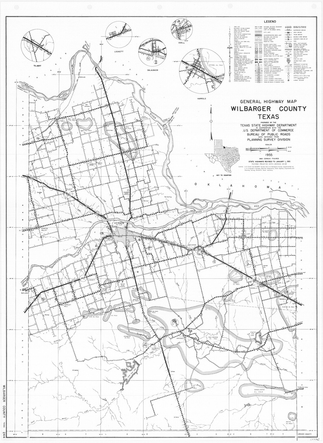
General Highway Map, Wilbarger County, Texas
-
Map/Doc
79710
-
Collection
Texas State Library and Archives
-
Object Dates
1961 (Creation Date)
-
People and Organizations
Texas State Highway Department (Publisher)
-
Counties
Wilbarger
-
Subjects
County
-
Height x Width
24.9 x 18.2 inches
63.3 x 46.2 cm
-
Comments
Prints available courtesy of the Texas State Library and Archives.
More info can be found here: TSLAC Map 05336
Part of: Texas State Library and Archives
Map of the Republic of Texas and the Adjacent Territories, Indicating the Grants of Land Conceded under the Empresario System of Mexico

Print $20.00
Map of the Republic of Texas and the Adjacent Territories, Indicating the Grants of Land Conceded under the Empresario System of Mexico
1841
Size 13.4 x 16.7 inches
Map/Doc 76244
General Highway Map. Detail of Cities and Towns in Tarrant County, Texas. City Map, Fort Worth and vicinity, Tarrant County, Texas

Print $20.00
General Highway Map. Detail of Cities and Towns in Tarrant County, Texas. City Map, Fort Worth and vicinity, Tarrant County, Texas
1961
Size 18.2 x 24.9 inches
Map/Doc 79667
General Highway Map, Mills County, Texas

Print $20.00
General Highway Map, Mills County, Texas
1961
Size 18.2 x 24.6 inches
Map/Doc 79599
General Highway Map, Bosque County, Texas

Print $20.00
General Highway Map, Bosque County, Texas
1961
Size 24.7 x 18.1 inches
Map/Doc 79378
Map of the City of San Antonio

Print $20.00
Map of the City of San Antonio
1909
Size 28.3 x 28.6 inches
Map/Doc 76293
General Highway Map, San Patricio County, Texas

Print $20.00
General Highway Map, San Patricio County, Texas
1940
Size 18.3 x 25.0 inches
Map/Doc 79237
Topographic Map of Big Bend Area

Print $20.00
Topographic Map of Big Bend Area
1923
Size 35.5 x 40.7 inches
Map/Doc 79758
General Highway Map, Willacy County, Texas

Print $20.00
General Highway Map, Willacy County, Texas
1940
Size 18.5 x 24.8 inches
Map/Doc 79279
General Highway Map, Falls County, Texas

Print $20.00
General Highway Map, Falls County, Texas
1961
Size 18.2 x 24.5 inches
Map/Doc 79462
General Highway Map, Randall County, Texas

Print $20.00
General Highway Map, Randall County, Texas
1961
Size 18.1 x 24.5 inches
Map/Doc 79635
General Highway Map, Cooke County, Texas

Print $20.00
General Highway Map, Cooke County, Texas
1940
Size 25.2 x 18.3 inches
Map/Doc 79058
General Highway Map, Bell County, Texas

Print $20.00
General Highway Map, Bell County, Texas
1940
Size 18.5 x 25.2 inches
Map/Doc 79015
You may also like
Smith County Sketch File 5

Print $6.00
- Digital $50.00
Smith County Sketch File 5
1857
Size 8.4 x 7.8 inches
Map/Doc 36754
Montgomery Co.

Print $40.00
- Digital $50.00
Montgomery Co.
1943
Size 45.2 x 54.8 inches
Map/Doc 95594
Eastland County Working Sketch 14

Print $20.00
- Digital $50.00
Eastland County Working Sketch 14
1919
Size 18.2 x 17.1 inches
Map/Doc 68795
Flight Mission No. CRC-2R, Frame 54, Chambers County

Print $20.00
- Digital $50.00
Flight Mission No. CRC-2R, Frame 54, Chambers County
1956
Size 18.5 x 22.3 inches
Map/Doc 84727
Duval County Working Sketch 46

Print $20.00
- Digital $50.00
Duval County Working Sketch 46
1980
Size 29.4 x 27.2 inches
Map/Doc 68770
Somervell County Working Sketch 3

Print $20.00
- Digital $50.00
Somervell County Working Sketch 3
1968
Size 23.0 x 30.4 inches
Map/Doc 63907
Concho County

Print $20.00
- Digital $50.00
Concho County
1947
Size 46.8 x 36.9 inches
Map/Doc 73115
Flight Mission No. BQR-14K, Frame 38, Brazoria County

Print $20.00
- Digital $50.00
Flight Mission No. BQR-14K, Frame 38, Brazoria County
1952
Size 18.8 x 22.3 inches
Map/Doc 84095
Red River County Working Sketch 28

Print $20.00
- Digital $50.00
Red River County Working Sketch 28
1961
Size 28.1 x 38.7 inches
Map/Doc 72011
Harris County Working Sketch 66

Print $40.00
- Digital $50.00
Harris County Working Sketch 66
1955
Size 33.7 x 49.7 inches
Map/Doc 65958
Map of the State of Texas [East Part]
![81920, Map of the State of Texas [East Part], General Map Collection](https://historictexasmaps.com/wmedia_w700/maps/81920.tif.jpg)
Print $40.00
- Digital $50.00
Map of the State of Texas [East Part]
1938
Size 67.8 x 37.3 inches
Map/Doc 81920
Midland County Working Sketch 15

Print $20.00
- Digital $50.00
Midland County Working Sketch 15
1953
Size 27.2 x 28.6 inches
Map/Doc 70995