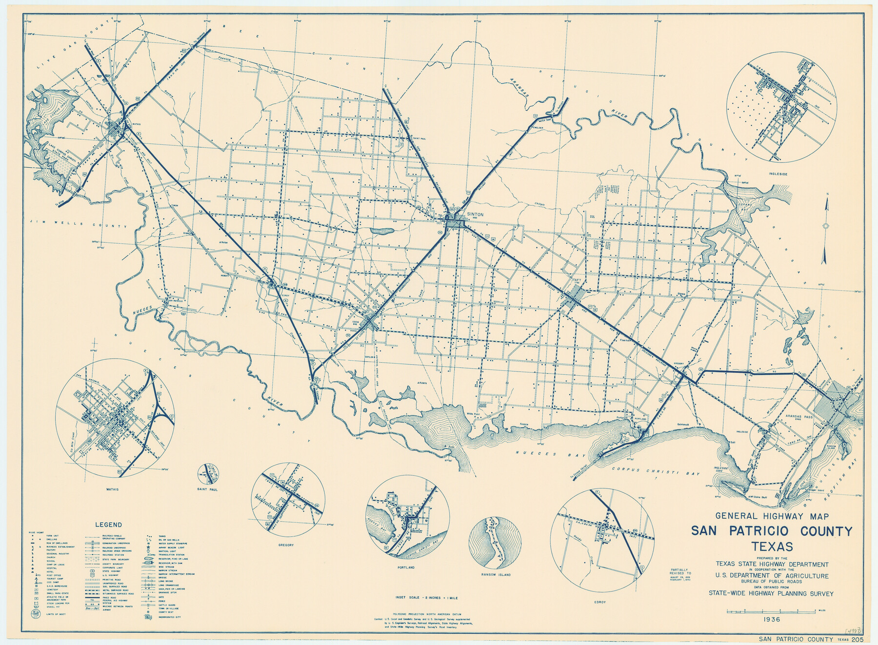
General Highway Map, San Patricio County, Texas
-
Map/Doc
79237
-
Collection
Texas State Library and Archives
-
Object Dates
1940 (Creation Date)
-
People and Organizations
Texas State Highway Department (Publisher)
-
Counties
San Patricio
-
Subjects
County
-
Height x Width
18.3 x 25.0 inches
46.5 x 63.5 cm
-
Comments
Prints available courtesy of the Texas State Library and Archives.
More info can be found here: TSLAC Map 04987
Part of: Texas State Library and Archives
General Highway Map, Crockett County, Texas

Print $20.00
General Highway Map, Crockett County, Texas
1940
Size 18.3 x 25.1 inches
Map/Doc 79062
General Highway Map, Dallam County, Hartley County, Texas

Print $20.00
General Highway Map, Dallam County, Hartley County, Texas
1940
Size 18.3 x 25.1 inches
Map/Doc 79065
General Highway Map, Liberty County, Texas

Print $20.00
General Highway Map, Liberty County, Texas
1961
Size 18.1 x 24.6 inches
Map/Doc 79571
Corpus Christi is the Sportsman's Paradise

Print $20.00
Corpus Christi is the Sportsman's Paradise
1942
Size 26.7 x 16.3 inches
Map/Doc 79324
Richardsons New Map of the State of Texas Including Part of Mexico Compiled from Government Surveys and other Authentic Documents

Print $20.00
Richardsons New Map of the State of Texas Including Part of Mexico Compiled from Government Surveys and other Authentic Documents
1860
Size 26.7 x 34.5 inches
Map/Doc 79735
General Highway Map, Hartley County, Texas

Print $20.00
General Highway Map, Hartley County, Texas
1961
Size 24.4 x 18.0 inches
Map/Doc 79511
General Highway Map, Navarro County, Texas

Print $20.00
General Highway Map, Navarro County, Texas
1961
Size 19.3 x 25.0 inches
Map/Doc 79610
Map of Central Texas Oil Fields

Print $20.00
Map of Central Texas Oil Fields
1918
Size 27.1 x 21.5 inches
Map/Doc 76295
General Highway Map, Red River County, Texas

Print $20.00
General Highway Map, Red River County, Texas
1940
Size 25.0 x 18.3 inches
Map/Doc 79226
General Highway Map. Detail of Cities and Towns in Potter County, Texas [Amarillo and vicinity]
![79221, General Highway Map. Detail of Cities and Towns in Potter County, Texas [Amarillo and vicinity], Texas State Library and Archives](https://historictexasmaps.com/wmedia_w700/maps/79221.tif.jpg)
Print $20.00
General Highway Map. Detail of Cities and Towns in Potter County, Texas [Amarillo and vicinity]
1940
Size 24.6 x 18.2 inches
Map/Doc 79221
General Highway Map, Houston County, Texas

Print $20.00
General Highway Map, Houston County, Texas
1940
Size 18.3 x 24.8 inches
Map/Doc 79133
General Highway Map, Cherokee County, Texas

Print $20.00
General Highway Map, Cherokee County, Texas
1939
Size 25.2 x 18.5 inches
Map/Doc 79045
You may also like

Duval County Rolled Sketch Pressly No. 1A

Print $20.00
- Digital $50.00
Duval County Rolled Sketch Pressly No. 1A
1935
Size 25.4 x 37.6 inches
Map/Doc 5769
Harrison County Rolled Sketch 6

Print $20.00
- Digital $50.00
Harrison County Rolled Sketch 6
1952
Size 23.4 x 24.2 inches
Map/Doc 6152
Andrews County Sketch File 16

Print $12.00
- Digital $50.00
Andrews County Sketch File 16
1934
Size 11.2 x 8.8 inches
Map/Doc 12897
Webb County Working Sketch 78

Print $20.00
- Digital $50.00
Webb County Working Sketch 78
1977
Size 35.0 x 42.1 inches
Map/Doc 72445
Chambers County Sketch File 47

Print $211.00
- Digital $50.00
Chambers County Sketch File 47
1927
Size 14.3 x 9.0 inches
Map/Doc 17899
Burleson County Working Sketch 8

Print $20.00
- Digital $50.00
Burleson County Working Sketch 8
1980
Size 29.3 x 23.2 inches
Map/Doc 67727
Hutchinson County Sketch File 5a

Print $6.00
- Digital $50.00
Hutchinson County Sketch File 5a
1900
Size 9.7 x 6.4 inches
Map/Doc 27195
Shackelford County Working Sketch 3

Print $20.00
- Digital $50.00
Shackelford County Working Sketch 3
1919
Size 23.2 x 17.5 inches
Map/Doc 63843
Hardin County Sketch File 48

Print $20.00
- Digital $50.00
Hardin County Sketch File 48
Size 17.8 x 18.4 inches
Map/Doc 11634
[Capitol League Lands in SE corner of Lamb County and along the north line of Lamb and Bailey]
![90244, [Capitol League Lands in SE corner of Lamb County and along the north line of Lamb and Bailey], Twichell Survey Records](https://historictexasmaps.com/wmedia_w700/maps/90244-1.tif.jpg)
Print $20.00
- Digital $50.00
[Capitol League Lands in SE corner of Lamb County and along the north line of Lamb and Bailey]
Size 27.7 x 19.7 inches
Map/Doc 90244
Colorado County Sketch File 34

Print $86.00
- Digital $50.00
Colorado County Sketch File 34
1996
Size 14.2 x 8.8 inches
Map/Doc 18992