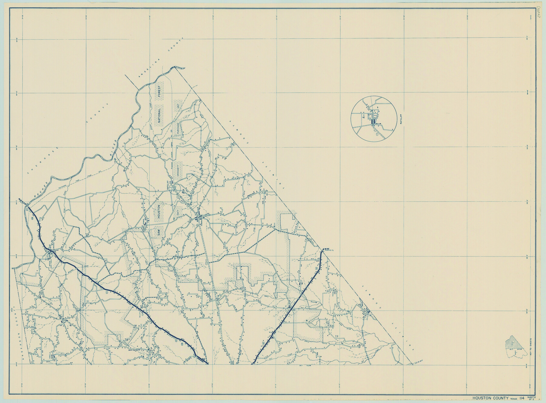
General Highway Map, Houston County, Texas
-
Map/Doc
79133
-
Collection
Texas State Library and Archives
-
Object Dates
1940 (Creation Date)
-
People and Organizations
Texas State Highway Department (Publisher)
-
Counties
Houston
-
Subjects
County
-
Height x Width
18.3 x 24.8 inches
46.5 x 63.0 cm
-
Comments
Prints available courtesy of the Texas State Library and Archives.
More info can be found here: TSLAC Map 04896
Part of: Texas State Library and Archives
General Highway Map, Val Verde County, Texas

Print $20.00
General Highway Map, Val Verde County, Texas
1940
Size 25.0 x 18.4 inches
Map/Doc 79266
Map of the United States of America with its territories and districts including also a part of upper and lower Canada and Mexico

Print $20.00
Map of the United States of America with its territories and districts including also a part of upper and lower Canada and Mexico
1835
Size 30.3 x 43.2 inches
Map/Doc 79728
General Highway Map, Roberts County, Texas

Print $20.00
General Highway Map, Roberts County, Texas
1961
Size 18.2 x 24.4 inches
Map/Doc 79640
General Highway Map, Zapata County, Texas

Print $20.00
General Highway Map, Zapata County, Texas
1961
Size 18.2 x 24.8 inches
Map/Doc 79721
General Highway Map, Hale County, Texas

Print $20.00
General Highway Map, Hale County, Texas
1961
Size 24.7 x 18.2 inches
Map/Doc 79493
General Highway Map, Castro County, Texas

Print $20.00
General Highway Map, Castro County, Texas
1940
Size 18.5 x 25.1 inches
Map/Doc 79043
General Highway Map, Reagan County, Texas

Print $20.00
General Highway Map, Reagan County, Texas
1940
Size 25.0 x 18.2 inches
Map/Doc 79225
The Federal Aid Highway System Progress Map

Print $20.00
The Federal Aid Highway System Progress Map
1931
Size 31.4 x 22.1 inches
Map/Doc 79745
General Highway Map, Refugio County, Texas

Print $20.00
General Highway Map, Refugio County, Texas
1940
Size 18.3 x 25.0 inches
Map/Doc 79228
Clason's Guide Map Texas and Northern Mexico

Print $20.00
Clason's Guide Map Texas and Northern Mexico
1924
Size 21.3 x 28.4 inches
Map/Doc 76314
General Highway Map, Rains County, Wood County, Texas

Print $20.00
General Highway Map, Rains County, Wood County, Texas
1939
Size 18.2 x 24.8 inches
Map/Doc 79223
Carte Geographique, Statistique et Historique du Mexique

Print $20.00
Carte Geographique, Statistique et Historique du Mexique
1824
Size 22.3 x 28.1 inches
Map/Doc 79315
You may also like
Bailey County Sketch File 1

Print $40.00
- Digital $50.00
Bailey County Sketch File 1
1882
Size 15.8 x 15.3 inches
Map/Doc 10880
Val Verde County Rolled Sketch 72

Print $20.00
- Digital $50.00
Val Verde County Rolled Sketch 72
Size 15.2 x 28.5 inches
Map/Doc 8134
Jefferson County Working Sketch 6

Print $20.00
- Digital $50.00
Jefferson County Working Sketch 6
1930
Size 34.7 x 34.8 inches
Map/Doc 66549
Flight Mission No. CLL-1N, Frame 82, Willacy County

Print $20.00
- Digital $50.00
Flight Mission No. CLL-1N, Frame 82, Willacy County
1954
Size 18.3 x 22.1 inches
Map/Doc 87028
Pecos County Rolled Sketch DK3

Print $20.00
- Digital $50.00
Pecos County Rolled Sketch DK3
1938
Size 35.3 x 42.3 inches
Map/Doc 9715
Red River County Sketch File 11

Print $4.00
- Digital $50.00
Red River County Sketch File 11
Size 11.8 x 8.1 inches
Map/Doc 35127
Bell County Working Sketch 14

Print $20.00
- Digital $50.00
Bell County Working Sketch 14
1966
Size 38.7 x 30.8 inches
Map/Doc 67354
Flight Mission No. CGI-1N, Frame 142, Cameron County

Print $20.00
- Digital $50.00
Flight Mission No. CGI-1N, Frame 142, Cameron County
1955
Size 18.5 x 22.2 inches
Map/Doc 84498
Pecos County Working Sketch 37

Print $20.00
- Digital $50.00
Pecos County Working Sketch 37
1939
Size 30.0 x 43.0 inches
Map/Doc 71509
Pecos County Rolled Sketch 162

Print $20.00
- Digital $50.00
Pecos County Rolled Sketch 162
Size 47.2 x 21.0 inches
Map/Doc 9741
Pecos County Sketch File 61

Print $40.00
- Digital $50.00
Pecos County Sketch File 61
1918
Size 16.3 x 15.3 inches
Map/Doc 33788
Fayette County Boundary File 2a

Print $8.00
- Digital $50.00
Fayette County Boundary File 2a
Size 14.9 x 9.3 inches
Map/Doc 53345