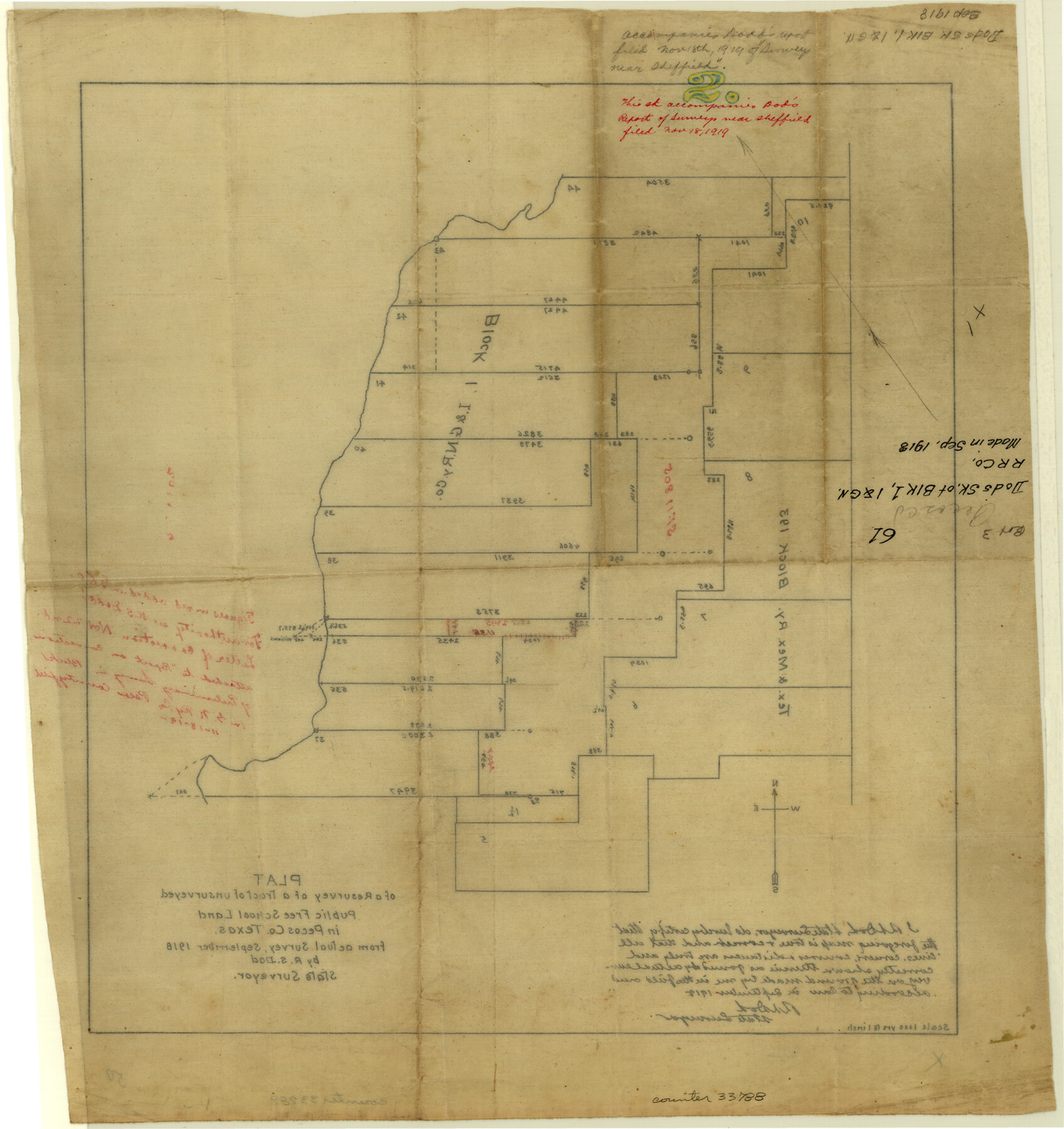
Pecos County Sketch File 61
Plat of a resurvey of a tract of unsurveyed Public Free School Land in Pecos County, Texas
-
Map/Doc
33788
-
Collection
General Map Collection
-
Object Dates
9/1918 (Creation Date)
9/1918 (Survey Date)
-
People and Organizations
R.S. Dod (Surveyor/Engineer)
-
Counties
Pecos
-
Subjects
Surveying Sketch File
-
Height x Width
16.3 x 15.3 inches
41.4 x 38.9 cm
-
Medium
paper, manuscript
Part of: General Map Collection
Flight Mission No. BRA-7M, Frame 12, Jefferson County

Print $20.00
- Digital $50.00
Flight Mission No. BRA-7M, Frame 12, Jefferson County
1953
Size 18.5 x 22.3 inches
Map/Doc 85463
Orange County Sketch File 8

Print $6.00
- Digital $50.00
Orange County Sketch File 8
Size 11.0 x 16.1 inches
Map/Doc 33311
Fractional Township No. 8 South Range No. 22 East of the Indian Meridian, Indian Territory

Print $20.00
- Digital $50.00
Fractional Township No. 8 South Range No. 22 East of the Indian Meridian, Indian Territory
1897
Size 19.2 x 24.2 inches
Map/Doc 75239
Flight Mission No. CRC-4R, Frame 81, Chambers County

Print $20.00
- Digital $50.00
Flight Mission No. CRC-4R, Frame 81, Chambers County
1956
Size 18.7 x 22.5 inches
Map/Doc 84885
Comanche County Sketch File 9

Print $4.00
- Digital $50.00
Comanche County Sketch File 9
1859
Size 6.0 x 9.1 inches
Map/Doc 19068
Freestone County Sketch File 28

Print $12.00
- Digital $50.00
Freestone County Sketch File 28
2002
Size 11.2 x 8.9 inches
Map/Doc 78602
Flight Mission No. CRK-7P, Frame 25, Refugio County

Print $20.00
- Digital $50.00
Flight Mission No. CRK-7P, Frame 25, Refugio County
1956
Size 18.6 x 22.3 inches
Map/Doc 86945
Brewster County Sketch File 41

Print $12.00
- Digital $50.00
Brewster County Sketch File 41
Size 6.9 x 14.5 inches
Map/Doc 16304
Briscoe County Sketch File P

Print $40.00
- Digital $50.00
Briscoe County Sketch File P
Size 23.1 x 34.0 inches
Map/Doc 11014
Val Verde County Sketch File 6

Print $32.00
- Digital $50.00
Val Verde County Sketch File 6
1889
Size 19.6 x 16.1 inches
Map/Doc 12562
[Sketch for Mineral Application 19560 - 19588 - San Bernard River]
![65579, [Sketch for Mineral Application 19560 - 19588 - San Bernard River], General Map Collection](https://historictexasmaps.com/wmedia_w700/maps/65579.tif.jpg)
Print $40.00
- Digital $50.00
[Sketch for Mineral Application 19560 - 19588 - San Bernard River]
1928
Size 33.0 x 98.6 inches
Map/Doc 65579
Reagan County Rolled Sketch 35

Print $20.00
- Digital $50.00
Reagan County Rolled Sketch 35
Size 26.4 x 38.4 inches
Map/Doc 7448
You may also like
Gregg County Working Sketch 13

Print $20.00
- Digital $50.00
Gregg County Working Sketch 13
1940
Size 30.3 x 24.2 inches
Map/Doc 63280
Throckmorton County Boundary File 4

Print $6.00
- Digital $50.00
Throckmorton County Boundary File 4
Size 14.3 x 8.8 inches
Map/Doc 59283
Flight Mission No. BRA-8M, Frame 130, Jefferson County

Print $20.00
- Digital $50.00
Flight Mission No. BRA-8M, Frame 130, Jefferson County
1953
Size 15.8 x 15.7 inches
Map/Doc 85626
Karnes County Sketch File 15

Print $28.00
- Digital $50.00
Karnes County Sketch File 15
1922
Size 11.4 x 8.8 inches
Map/Doc 28618
Trinity County Sketch File 20

Print $20.00
- Digital $50.00
Trinity County Sketch File 20
Size 21.3 x 27.9 inches
Map/Doc 12485
[Block 1 and vicinity]
![90703, [Block 1 and vicinity], Twichell Survey Records](https://historictexasmaps.com/wmedia_w700/maps/90703-1.tif.jpg)
Print $20.00
- Digital $50.00
[Block 1 and vicinity]
Size 25.3 x 24.1 inches
Map/Doc 90703
[Channing Vacancy, Leagues 217- 235 and Vicinity]
![91483, [Channing Vacancy, Leagues 217- 235 and Vicinity], Twichell Survey Records](https://historictexasmaps.com/wmedia_w700/maps/91483-1.tif.jpg)
Print $20.00
- Digital $50.00
[Channing Vacancy, Leagues 217- 235 and Vicinity]
Size 26.7 x 27.6 inches
Map/Doc 91483

University of Texas System University Lands

Print $20.00
- Digital $50.00
University of Texas System University Lands
1936
Size 23.2 x 17.6 inches
Map/Doc 93236
Kimble County Boundary File 3

Print $44.00
- Digital $50.00
Kimble County Boundary File 3
Size 9.8 x 32.4 inches
Map/Doc 64846
Cameron County Rolled Sketch Z5

Print $20.00
- Digital $50.00
Cameron County Rolled Sketch Z5
1937
Size 28.7 x 33.6 inches
Map/Doc 5403
DeWitt County Working Sketch 11

Print $20.00
- Digital $50.00
DeWitt County Working Sketch 11
1980
Size 15.9 x 12.8 inches
Map/Doc 68601