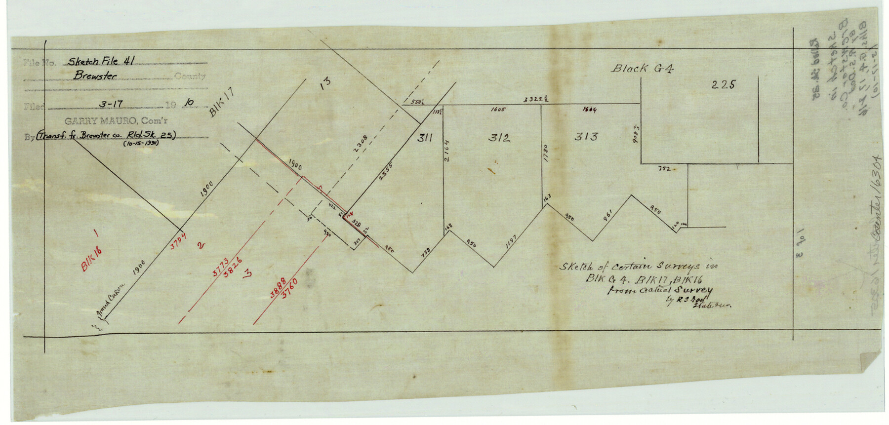
Brewster County Sketch File 41
[Sketches of certain surveys in Blocks G-4, 16, and 17]
-
Map/Doc
16304
-
Collection
General Map Collection
-
Object Dates
1910/3/17 (File Date)
-
People and Organizations
R.S. Dod (Surveyor/Engineer)
-
Counties
Brewster
-
Subjects
Surveying Sketch File
-
Height x Width
6.9 x 14.5 inches
17.5 x 36.8 cm
-
Medium
linen, manuscript
-
Features
Grand Canyon
Part of: General Map Collection
[Map of Texas and Pacific Blocks from Brazos River westward through Palo Pinto, Stephens, Shackelford, Jones, Callahan, Taylor, Fisher, Nolan and Mitchell Counties]
![93457, [Map of Texas and Pacific Blocks from Brazos River westward through Palo Pinto, Stephens, Shackelford, Jones, Callahan, Taylor, Fisher, Nolan and Mitchell Counties], General Map Collection](https://historictexasmaps.com/wmedia_w700/maps/93457-1.tif.jpg)
Print $20.00
- Digital $50.00
[Map of Texas and Pacific Blocks from Brazos River westward through Palo Pinto, Stephens, Shackelford, Jones, Callahan, Taylor, Fisher, Nolan and Mitchell Counties]
Size 35.0 x 19.3 inches
Map/Doc 93457
McMullen County Working Sketch 18

Print $20.00
- Digital $50.00
McMullen County Working Sketch 18
1943
Size 17.0 x 16.6 inches
Map/Doc 70719
Potter County Boundary File 6b

Print $20.00
- Digital $50.00
Potter County Boundary File 6b
Size 37.9 x 8.7 inches
Map/Doc 58040
Webb County Working Sketch 1

Print $20.00
- Digital $50.00
Webb County Working Sketch 1
Size 15.6 x 14.4 inches
Map/Doc 72366
Freestone County Working Sketch 15

Print $40.00
- Digital $50.00
Freestone County Working Sketch 15
1980
Size 56.5 x 33.7 inches
Map/Doc 69257
Burnet County Working Sketch 23

Print $40.00
- Digital $50.00
Burnet County Working Sketch 23
1987
Size 43.8 x 51.9 inches
Map/Doc 67866
Shackelford County Working Sketch Graphic Index

Print $20.00
- Digital $50.00
Shackelford County Working Sketch Graphic Index
1972
Size 42.2 x 36.1 inches
Map/Doc 76696
Flight Mission No. DAG-24K, Frame 124, Matagorda County

Print $20.00
- Digital $50.00
Flight Mission No. DAG-24K, Frame 124, Matagorda County
1953
Size 18.4 x 22.3 inches
Map/Doc 86542
Padre Island National Seashore, Texas - Dependent Resurvey

Print $4.00
- Digital $50.00
Padre Island National Seashore, Texas - Dependent Resurvey
2001
Size 18.4 x 24.1 inches
Map/Doc 60553
Shelby County Working Sketch 31a

Print $40.00
- Digital $50.00
Shelby County Working Sketch 31a
2003
Size 32.6 x 70.2 inches
Map/Doc 78643
Lynn County Working Sketch 4

Print $20.00
- Digital $50.00
Lynn County Working Sketch 4
1965
Size 33.5 x 33.8 inches
Map/Doc 70674
[Surveys near Lake Soda made under G.W. Smyth, Commissioner]
![73, [Surveys near Lake Soda made under G.W. Smyth, Commissioner], General Map Collection](https://historictexasmaps.com/wmedia_w700/maps/73.tif.jpg)
Print $20.00
- Digital $50.00
[Surveys near Lake Soda made under G.W. Smyth, Commissioner]
1835
Size 16.0 x 19.3 inches
Map/Doc 73
You may also like
Wichita County Boundary File 2a

Print $28.00
- Digital $50.00
Wichita County Boundary File 2a
Size 14.0 x 8.9 inches
Map/Doc 59906
[Townships 1 & 2, Blocks 53, 54 & 55]
![92952, [Townships 1 & 2, Blocks 53, 54 & 55], Twichell Survey Records](https://historictexasmaps.com/wmedia_w700/maps/92952-1.tif.jpg)
Print $20.00
- Digital $50.00
[Townships 1 & 2, Blocks 53, 54 & 55]
Size 34.3 x 20.0 inches
Map/Doc 92952

Edwards County Working Sketch 17

Print $20.00
- Digital $50.00
Edwards County Working Sketch 17
1930
Size 32.3 x 26.8 inches
Map/Doc 68893
Flight Mission No. CGI-4N, Frame 171, Cameron County

Print $20.00
- Digital $50.00
Flight Mission No. CGI-4N, Frame 171, Cameron County
1955
Size 18.5 x 22.4 inches
Map/Doc 84674
Maps of Gulf Intracoastal Waterway, Texas - Sabine River to the Rio Grande and connecting waterways including ship channels

Print $20.00
- Digital $50.00
Maps of Gulf Intracoastal Waterway, Texas - Sabine River to the Rio Grande and connecting waterways including ship channels
1966
Size 15.7 x 22.0 inches
Map/Doc 61987
Flight Mission No. DQO-8K, Frame 54, Galveston County

Print $20.00
- Digital $50.00
Flight Mission No. DQO-8K, Frame 54, Galveston County
1952
Size 18.5 x 22.2 inches
Map/Doc 85161
The Republic County of Austin. Proposed, Late Fall 1837

Print $20.00
The Republic County of Austin. Proposed, Late Fall 1837
2020
Size 14.8 x 21.7 inches
Map/Doc 96080
Panola County Rolled Sketch 3

Print $1246.00
- Digital $50.00
Panola County Rolled Sketch 3
1949
Size 10.3 x 15.2 inches
Map/Doc 47978
Runnels County Sketch File 36

Print $20.00
Runnels County Sketch File 36
1889
Size 20.9 x 19.6 inches
Map/Doc 12267
Loving County Working Sketch 17

Print $20.00
- Digital $50.00
Loving County Working Sketch 17
1976
Size 43.5 x 38.2 inches
Map/Doc 70651
[Sketch Showing Loma Blanca , El Tule and San Antonio de Encinal Leagues in Brooks County, Texas]
![624, [Sketch Showing Loma Blanca , El Tule and San Antonio de Encinal Leagues in Brooks County, Texas], Maddox Collection](https://historictexasmaps.com/wmedia_w700/maps/00624.tif.jpg)
Print $3.00
- Digital $50.00
[Sketch Showing Loma Blanca , El Tule and San Antonio de Encinal Leagues in Brooks County, Texas]
Size 9.3 x 14.2 inches
Map/Doc 624