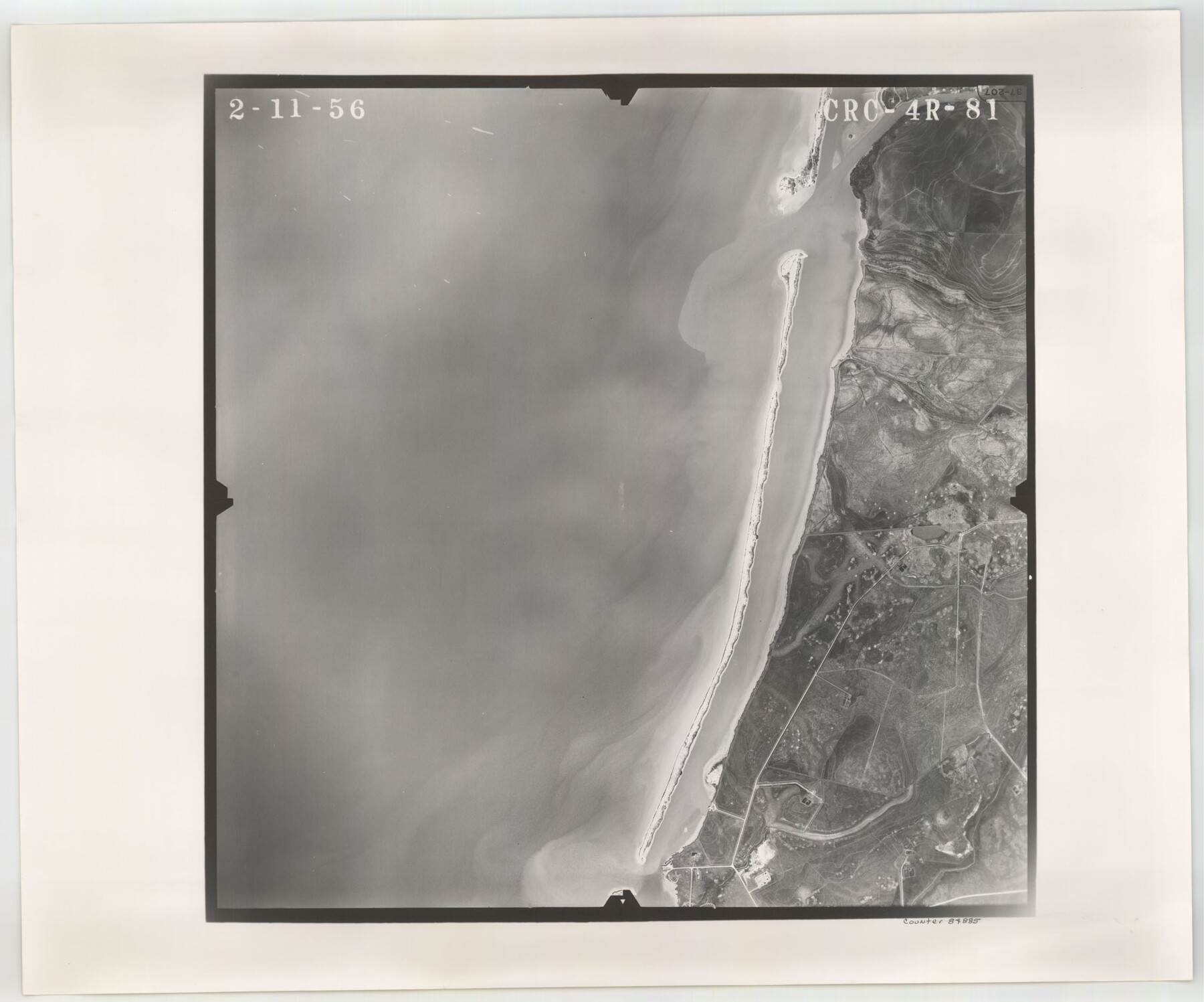
Flight Mission No. CRC-4R, Frame 81, Chambers County
CRC-4R-81
-
Map/Doc
84885
-
Collection
General Map Collection
-
Object Dates
1956/2/11 (Creation Date)
-
People and Organizations
U. S. Department of Agriculture (Publisher)
-
Counties
Chambers
-
Subjects
Aerial Photograph
-
Height x Width
18.7 x 22.5 inches
47.5 x 57.2 cm
-
Comments
Flown by Jack Ammann Photogrammetric Engineers, Inc. of San Antonio, Texas.
Part of: General Map Collection
Brewster County Rolled Sketch 114

Print $20.00
- Digital $50.00
Brewster County Rolled Sketch 114
1964
Size 11.9 x 18.3 inches
Map/Doc 5280
Galveston County Working Sketch 4

Print $20.00
- Digital $50.00
Galveston County Working Sketch 4
1930
Size 19.7 x 17.2 inches
Map/Doc 69341
Sterling County Sketch File 6

Print $12.00
- Digital $50.00
Sterling County Sketch File 6
1912
Size 5.7 x 8.8 inches
Map/Doc 37115
Flight Mission No. DAG-23K, Frame 16, Matagorda County

Print $20.00
- Digital $50.00
Flight Mission No. DAG-23K, Frame 16, Matagorda County
1953
Size 18.5 x 22.2 inches
Map/Doc 86478
[Gonzales District]
![16837, [Gonzales District], General Map Collection](https://historictexasmaps.com/wmedia_w700/maps/16837.tif.jpg)
Print $20.00
- Digital $50.00
[Gonzales District]
1840
Size 42.8 x 37.0 inches
Map/Doc 16837
Map of the Country upon Upper Red-River explored in 1852 by Capt. R.B. Marcy 5th U.S. Infy. assisted by Bvt. Capt. G.B. McClellan U.S. Engs. under orders from the Head Quarters of the U.S. Army

Print $20.00
- Digital $50.00
Map of the Country upon Upper Red-River explored in 1852 by Capt. R.B. Marcy 5th U.S. Infy. assisted by Bvt. Capt. G.B. McClellan U.S. Engs. under orders from the Head Quarters of the U.S. Army
Size 18.7 x 36.0 inches
Map/Doc 95320
Edwards County Working Sketch 130

Print $20.00
- Digital $50.00
Edwards County Working Sketch 130
1982
Size 29.3 x 26.8 inches
Map/Doc 69006
Flight Mission No. DIX-10P, Frame 64, Aransas County

Print $20.00
- Digital $50.00
Flight Mission No. DIX-10P, Frame 64, Aransas County
1956
Size 18.7 x 22.3 inches
Map/Doc 83925
Flight Mission No. BRA-8M, Frame 71, Jefferson County

Print $20.00
- Digital $50.00
Flight Mission No. BRA-8M, Frame 71, Jefferson County
1953
Size 18.7 x 22.3 inches
Map/Doc 85591
Map of Matagorda County

Print $20.00
- Digital $50.00
Map of Matagorda County
1839
Size 23.5 x 32.2 inches
Map/Doc 3844
Leon County Working Sketch 45

Print $20.00
- Digital $50.00
Leon County Working Sketch 45
1980
Size 45.4 x 37.4 inches
Map/Doc 70444
Tom Green County Rolled Sketch 18

Print $20.00
- Digital $50.00
Tom Green County Rolled Sketch 18
Size 15.7 x 23.8 inches
Map/Doc 8001
You may also like

Map of the C.C. Browning survey 412 enlarged from General Land Office map of the west part of Travis County, Texas
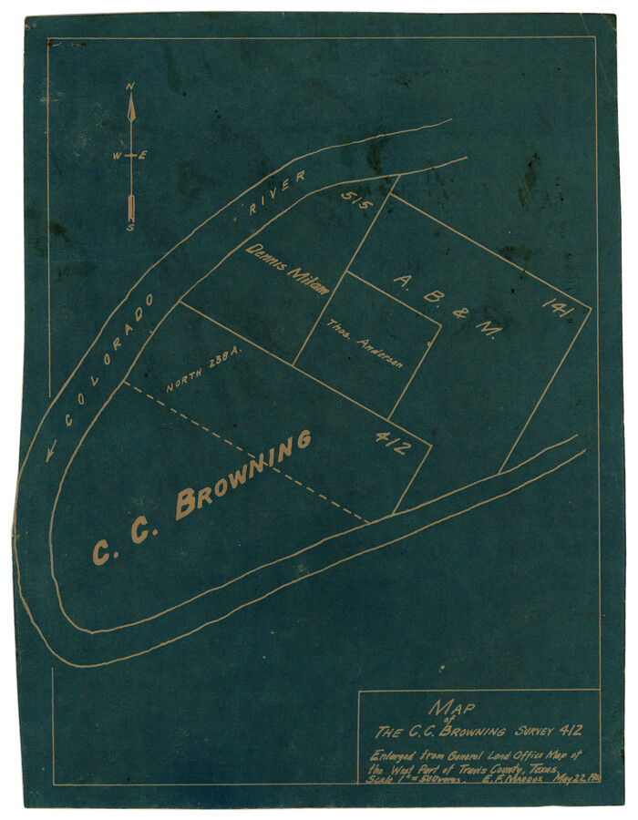
Print $3.00
- Digital $50.00
Map of the C.C. Browning survey 412 enlarged from General Land Office map of the west part of Travis County, Texas
1920
Size 11.3 x 9.1 inches
Map/Doc 10752
Flight Mission No. DCL-7C, Frame 65, Kenedy County

Print $20.00
- Digital $50.00
Flight Mission No. DCL-7C, Frame 65, Kenedy County
1943
Size 18.5 x 22.3 inches
Map/Doc 86051
Flight Mission No. CRC-4R, Frame 80, Chambers County

Print $20.00
- Digital $50.00
Flight Mission No. CRC-4R, Frame 80, Chambers County
1956
Size 18.6 x 22.4 inches
Map/Doc 84884
Hardin County Boundary File 40

Print $14.00
- Digital $50.00
Hardin County Boundary File 40
Size 9.0 x 3.5 inches
Map/Doc 54409
Sherman County Rolled Sketch 13

Print $20.00
- Digital $50.00
Sherman County Rolled Sketch 13
1951
Size 14.3 x 30.7 inches
Map/Doc 7791
Van Zandt County Sketch File 12

Print $6.00
- Digital $50.00
Van Zandt County Sketch File 12
1858
Size 10.2 x 8.0 inches
Map/Doc 39399
Old Miscellaneous File 30

Print $16.00
- Digital $50.00
Old Miscellaneous File 30
1845
Size 13.3 x 8.2 inches
Map/Doc 75740
Ochiltree County

Print $20.00
- Digital $50.00
Ochiltree County
1889
Size 23.1 x 19.5 inches
Map/Doc 3923
[Southeast part of County near Jas. H. Price Survey]
![91915, [Southeast part of County near Jas. H. Price Survey], Twichell Survey Records](https://historictexasmaps.com/wmedia_w700/maps/91915-1.tif.jpg)
Print $20.00
- Digital $50.00
[Southeast part of County near Jas. H. Price Survey]
Size 19.9 x 20.0 inches
Map/Doc 91915
Irion County Boundary File 4

Print $23.00
- Digital $50.00
Irion County Boundary File 4
Size 11.2 x 8.8 inches
Map/Doc 55350
Jasper County Sketch File 24

Print $4.00
- Digital $50.00
Jasper County Sketch File 24
1925
Size 10.9 x 8.3 inches
Map/Doc 27824