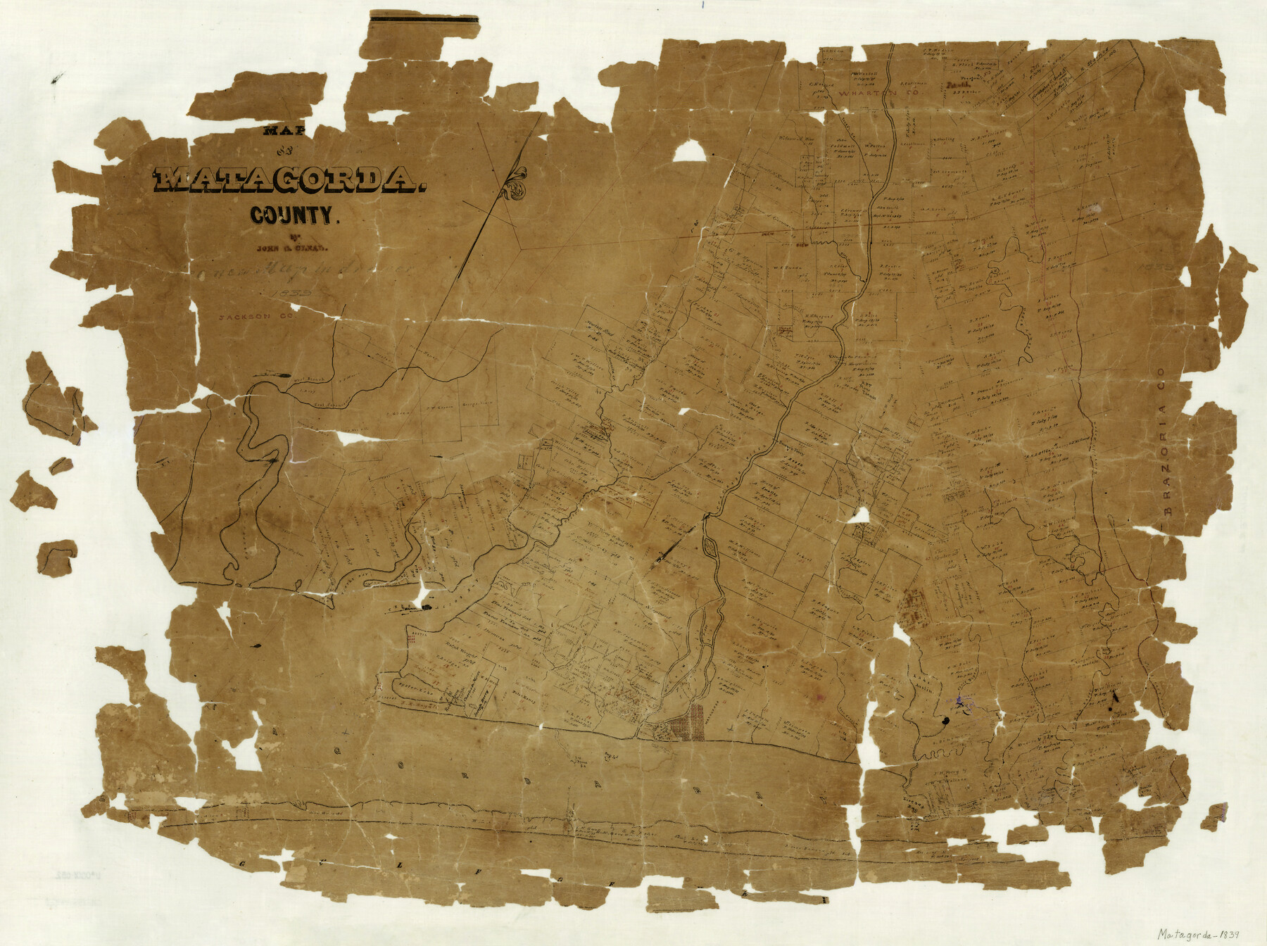
Map of Matagorda County
-
Map/Doc
3844
-
Collection
General Map Collection
-
Object Dates
1839 (Creation Date)
-
People and Organizations
John G. Clead (Draftsman)
-
Counties
Matagorda
-
Subjects
County
-
Height x Width
23.5 x 32.2 inches
59.7 x 81.8 cm
-
Features
Austin
Prairie Creek
Cedar Lake Bayou
Caney Bayou
Live Oak Bayou
Canoe Bayou
Lake Austin
Wm. Selvirk's Islands
Matagorda
Oyster Lake
Palacios
Troy Creek
Matagorda Bay
Dog Island
Deer Creek
Dressing Point
Live Oak Bay
Peace Slough
Gulf of Mexico
Post-Oak Creek
Cottonwood Creek
Tarillo Creek
Trespalacios Bayou
Preston
HT&B
Blue Creek
West Branch of Carancahua Bay
East Carancawa [sic] Creek
Juanita Creek
Trespalacios Creek
Jennings Creek
Long Pine Creek
Elliott's Ferry
Jones Creek
Linvill's Bayou
Buck Bayou
Snow's Ferry
Colorado River
Willson's Creek
Turtle Creek
Carancawa [sic] Bay
Turtle Bay
Trespalacios Bay
Part of: General Map Collection
Hood County Working Sketch 11

Print $20.00
- Digital $50.00
Hood County Working Sketch 11
1976
Size 19.7 x 25.2 inches
Map/Doc 66205
Crosby County Working Sketch 2

Print $20.00
- Digital $50.00
Crosby County Working Sketch 2
Size 18.2 x 18.0 inches
Map/Doc 68436
United States - Gulf Coast Texas - Southern part of Laguna Madre

Print $20.00
- Digital $50.00
United States - Gulf Coast Texas - Southern part of Laguna Madre
1941
Size 26.4 x 18.2 inches
Map/Doc 72956
Ellis County Sketch File 18a

Print $40.00
- Digital $50.00
Ellis County Sketch File 18a
Size 12.8 x 16.0 inches
Map/Doc 21864
Crockett County Rolled Sketch 41

Print $20.00
- Digital $50.00
Crockett County Rolled Sketch 41
Size 24.7 x 19.6 inches
Map/Doc 5591
Lampasas County Boundary File Index

Print $2.00
- Digital $50.00
Lampasas County Boundary File Index
Size 9.0 x 9.6 inches
Map/Doc 56092
Aransas County Working Sketch 26

Print $20.00
- Digital $50.00
Aransas County Working Sketch 26
1965
Size 40.8 x 29.4 inches
Map/Doc 67193
Webb County Rolled Sketch 24

Print $20.00
- Digital $50.00
Webb County Rolled Sketch 24
1930
Size 33.0 x 23.0 inches
Map/Doc 8184
Hardin County Sketch File 18

Print $6.00
- Digital $50.00
Hardin County Sketch File 18
1870
Size 9.8 x 8.6 inches
Map/Doc 25132
Gaines County Working Sketch 1

Print $40.00
- Digital $50.00
Gaines County Working Sketch 1
1937
Size 22.7 x 53.1 inches
Map/Doc 69301
Flight Mission No. DQO-8K, Frame 132, Galveston County

Print $20.00
- Digital $50.00
Flight Mission No. DQO-8K, Frame 132, Galveston County
1952
Size 18.8 x 22.6 inches
Map/Doc 85197
Bailey County Sketch File 21

Print $14.00
- Digital $50.00
Bailey County Sketch File 21
Size 11.3 x 8.8 inches
Map/Doc 13990
You may also like
Duval County Boundary File 3c

Print $12.00
- Digital $50.00
Duval County Boundary File 3c
Size 11.7 x 8.4 inches
Map/Doc 52732
Nueces County Rolled Sketch 52

Print $20.00
- Digital $50.00
Nueces County Rolled Sketch 52
1938
Size 31.3 x 31.7 inches
Map/Doc 9606
[Block Y2 and Part of Block 1, B. & B.]
![91169, [Block Y2 and Part of Block 1, B. & B.], Twichell Survey Records](https://historictexasmaps.com/wmedia_w700/maps/91169-1.tif.jpg)
Print $20.00
- Digital $50.00
[Block Y2 and Part of Block 1, B. & B.]
Size 26.2 x 17.6 inches
Map/Doc 91169
Van Zandt County Rolled Sketch 5

Print $20.00
- Digital $50.00
Van Zandt County Rolled Sketch 5
1946
Size 27.1 x 28.1 inches
Map/Doc 8146
Hudspeth County Rolled Sketch 46

Print $40.00
- Digital $50.00
Hudspeth County Rolled Sketch 46
Size 10.6 x 123.7 inches
Map/Doc 9221
Bandera County Working Sketch 41

Print $20.00
- Digital $50.00
Bandera County Working Sketch 41
1977
Size 31.3 x 37.7 inches
Map/Doc 67637
Flight Mission No. DAG-18K, Frame 186, Matagorda County

Print $20.00
- Digital $50.00
Flight Mission No. DAG-18K, Frame 186, Matagorda County
1952
Size 17.2 x 22.5 inches
Map/Doc 86378
La Salle County Sketch File 46

Print $20.00
- Digital $50.00
La Salle County Sketch File 46
Size 14.1 x 8.6 inches
Map/Doc 29603
Jefferson County Sketch File 15

Print $10.00
- Digital $50.00
Jefferson County Sketch File 15
1870
Size 8.6 x 7.6 inches
Map/Doc 28151
[Right of Way & Track Map, The Texas & Pacific Ry. Co. Main Line]
![64665, [Right of Way & Track Map, The Texas & Pacific Ry. Co. Main Line], General Map Collection](https://historictexasmaps.com/wmedia_w700/maps/64665.tif.jpg)
Print $20.00
- Digital $50.00
[Right of Way & Track Map, The Texas & Pacific Ry. Co. Main Line]
Size 11.0 x 18.4 inches
Map/Doc 64665
Flight Mission No. BRA-6M, Frame 73, Jefferson County

Print $20.00
- Digital $50.00
Flight Mission No. BRA-6M, Frame 73, Jefferson County
1953
Size 18.6 x 22.3 inches
Map/Doc 85417
[W. T. Brewer: M. McDonald, Ralph Gilpin, A. Vanhooser, John Baker, John R. Taylor Surveys]
![90963, [W. T. Brewer: M. McDonald, Ralph Gilpin, A. Vanhooser, John Baker, John R. Taylor Surveys], Twichell Survey Records](https://historictexasmaps.com/wmedia_w700/maps/90963-1.tif.jpg)
Print $2.00
- Digital $50.00
[W. T. Brewer: M. McDonald, Ralph Gilpin, A. Vanhooser, John Baker, John R. Taylor Surveys]
Size 8.8 x 11.3 inches
Map/Doc 90963