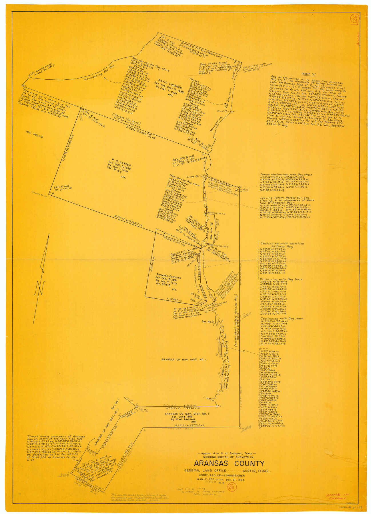
Aransas County Working Sketch 26
-
Map/Doc
67193
-
Collection
General Map Collection
-
Object Dates
12/21/1965 (Creation Date)
-
People and Organizations
Jerry Sadler (GLO Commissioner)
Roy Buckholts (Draftsman)
-
Counties
Aransas
-
Subjects
Surveying Working Sketch
-
Height x Width
40.8 x 29.4 inches
103.6 x 74.7 cm
-
Scale
1" = 300 varas
-
Comments
Surveys located about four miles North of Rockport, Texas.
Part of: General Map Collection
![94160, Austin and Vicinity [Recto], General Map Collection](https://historictexasmaps.com/wmedia_w700/maps/94160.tif.jpg)
Nueces County Sketch File 45

Print $6.00
- Digital $50.00
Nueces County Sketch File 45
Size 11.1 x 8.6 inches
Map/Doc 32641
Somervell County

Print $20.00
- Digital $50.00
Somervell County
1941
Size 27.5 x 26.7 inches
Map/Doc 63042
Harris County Working Sketch 87

Print $20.00
- Digital $50.00
Harris County Working Sketch 87
1972
Size 34.1 x 31.0 inches
Map/Doc 65979
Crane County Rolled Sketch 2

Print $40.00
- Digital $50.00
Crane County Rolled Sketch 2
1888
Size 55.3 x 29.0 inches
Map/Doc 8676
Chambers County Sketch File 54

Print $3.00
- Digital $50.00
Chambers County Sketch File 54
1895
Size 16.5 x 10.3 inches
Map/Doc 18093
Flight Mission No. BRA-16M, Frame 115, Jefferson County

Print $20.00
- Digital $50.00
Flight Mission No. BRA-16M, Frame 115, Jefferson County
1953
Size 18.5 x 22.2 inches
Map/Doc 85725
Nueces County Sketch File 2

Print $24.00
- Digital $50.00
Nueces County Sketch File 2
1847
Size 7.6 x 12.5 inches
Map/Doc 32500
Glasscock County Working Sketch 7

Print $20.00
- Digital $50.00
Glasscock County Working Sketch 7
1952
Size 36.8 x 31.9 inches
Map/Doc 63180
Coryell County Working Sketch 27

Print $20.00
- Digital $50.00
Coryell County Working Sketch 27
1988
Size 15.5 x 20.0 inches
Map/Doc 68234
Rio Grande, Madero Sheet

Print $20.00
- Digital $50.00
Rio Grande, Madero Sheet
1931
Size 33.0 x 38.5 inches
Map/Doc 65124
Jim Wells Co.

Print $20.00
- Digital $50.00
Jim Wells Co.
1966
Size 42.7 x 31.0 inches
Map/Doc 73198
You may also like
Newton County

Print $40.00
- Digital $50.00
Newton County
1946
Size 48.7 x 42.6 inches
Map/Doc 73250
Map of Taylor, Bastrop & Houston Railway through Colorado County, Texas

Print $20.00
- Digital $50.00
Map of Taylor, Bastrop & Houston Railway through Colorado County, Texas
1888
Size 12.7 x 20.0 inches
Map/Doc 64289
[Surveys along Tehuacano and Grindstone Creek, drawings X and Y]
![299, [Surveys along Tehuacano and Grindstone Creek, drawings X and Y], General Map Collection](https://historictexasmaps.com/wmedia_w700/maps/299.tif.jpg)
Print $20.00
- Digital $50.00
[Surveys along Tehuacano and Grindstone Creek, drawings X and Y]
1846
Size 12.4 x 18.3 inches
Map/Doc 299
Coke County Rolled Sketch 5

Print $20.00
- Digital $50.00
Coke County Rolled Sketch 5
1948
Size 25.5 x 23.6 inches
Map/Doc 5505
Block No. 45 of the H. & T. C. R.R. Co. and Block No. 4T of the T. & N. O. R.R. Co. in Hansford and Ochiltree Cos. as resurveyed by J.L. Long, State Surveyor

Print $20.00
- Digital $50.00
Block No. 45 of the H. & T. C. R.R. Co. and Block No. 4T of the T. & N. O. R.R. Co. in Hansford and Ochiltree Cos. as resurveyed by J.L. Long, State Surveyor
1888
Size 34.1 x 28.1 inches
Map/Doc 75820
Brazoria County Working Sketch 49a

Print $20.00
- Digital $50.00
Brazoria County Working Sketch 49a
2003
Size 35.0 x 35.0 inches
Map/Doc 78347
Portion of States Submerged Area in Matagorda Bay

Print $20.00
- Digital $50.00
Portion of States Submerged Area in Matagorda Bay
1922
Size 13.9 x 15.9 inches
Map/Doc 2951
[Map of the River Sabine from its mouth on the Gulf of Mexico in the sea to Logan's Ferry in Latitude 31° 58' 24" North]
![94005, [Map of the River Sabine from its mouth on the Gulf of Mexico in the sea to Logan's Ferry in Latitude 31° 58' 24" North], General Map Collection](https://historictexasmaps.com/wmedia_w700/maps/94005.tif.jpg)
Print $20.00
- Digital $50.00
[Map of the River Sabine from its mouth on the Gulf of Mexico in the sea to Logan's Ferry in Latitude 31° 58' 24" North]
Size 31.5 x 31.3 inches
Map/Doc 94005
Chambers County Sketch File 58

Print $2.00
- Digital $50.00
Chambers County Sketch File 58
1995
Size 9.1 x 14.7 inches
Map/Doc 18108
Brazoria County Rolled Sketch 50A

Print $20.00
- Digital $50.00
Brazoria County Rolled Sketch 50A
1932
Size 17.8 x 26.1 inches
Map/Doc 5188
Sabine Pass and Lake

Print $20.00
- Digital $50.00
Sabine Pass and Lake
1925
Size 43.6 x 28.0 inches
Map/Doc 69821
