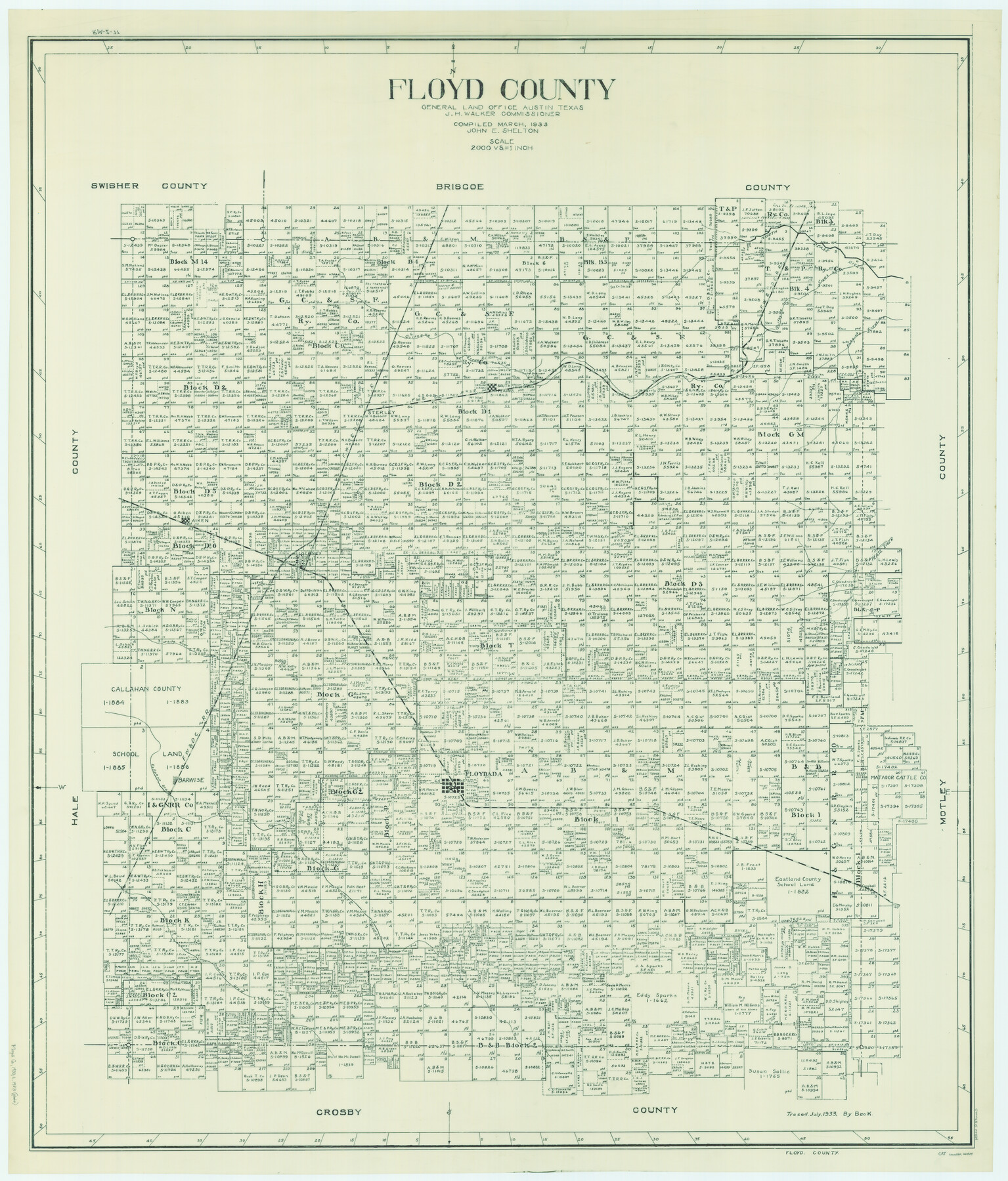
Floyd County
-
Map/Doc
66824
-
Collection
General Map Collection
-
Object Dates
1933 (Creation Date)
-
People and Organizations
Texas General Land Office (Publisher)
J.H. Walker (GLO Commissioner)
John E. Shelton Jr. (Compiler)
John E. Shelton Jr. (Draftsman)
-
Counties
Floyd
-
Subjects
County
-
Height x Width
46.3 x 39.4 inches
117.6 x 100.1 cm
-
Comments
Traced in July 1933 by Beck.
Part of: General Map Collection
Map of Wood County

Print $20.00
- Digital $50.00
Map of Wood County
1877
Size 16.8 x 17.1 inches
Map/Doc 4168
Flight Mission No. CRK-3P, Frame 177, Refugio County

Print $20.00
- Digital $50.00
Flight Mission No. CRK-3P, Frame 177, Refugio County
1956
Size 18.6 x 22.4 inches
Map/Doc 86924
Flight Mission No. CLL-1N, Frame 9, Willacy County

Print $20.00
- Digital $50.00
Flight Mission No. CLL-1N, Frame 9, Willacy County
1954
Size 18.4 x 22.1 inches
Map/Doc 86996
Val Verde County Rolled Sketch 71

Print $20.00
- Digital $50.00
Val Verde County Rolled Sketch 71
1958
Size 19.5 x 19.5 inches
Map/Doc 8133
Nueces County Rolled Sketch 79

Print $20.00
- Digital $50.00
Nueces County Rolled Sketch 79
1894
Size 38.1 x 31.3 inches
Map/Doc 9627
Anderson County Rolled Sketch 14

Print $20.00
- Digital $50.00
Anderson County Rolled Sketch 14
1997
Size 30.1 x 36.5 inches
Map/Doc 77159
Brewster County Rolled Sketch 98

Print $20.00
- Digital $50.00
Brewster County Rolled Sketch 98
1952
Size 29.3 x 38.0 inches
Map/Doc 8508
Llano County Working Sketch 14

Print $20.00
- Digital $50.00
Llano County Working Sketch 14
1989
Size 14.6 x 34.7 inches
Map/Doc 70632
Bowie County Rolled Sketch 2

Print $40.00
- Digital $50.00
Bowie County Rolled Sketch 2
Size 37.8 x 51.3 inches
Map/Doc 8454
Dallas County Working Sketch 1

Print $20.00
- Digital $50.00
Dallas County Working Sketch 1
Size 41.4 x 28.3 inches
Map/Doc 68567
Burnet County Working Sketch 23

Print $40.00
- Digital $50.00
Burnet County Working Sketch 23
1987
Size 43.8 x 51.9 inches
Map/Doc 67866
Hemphill County Working Sketch 21

Print $40.00
- Digital $50.00
Hemphill County Working Sketch 21
1973
Size 79.0 x 32.6 inches
Map/Doc 66116
You may also like
Val Verde County Boundary File 1

Print $6.00
- Digital $50.00
Val Verde County Boundary File 1
Size 14.3 x 8.7 inches
Map/Doc 59572
Foard County Working Sketch 4

Print $20.00
- Digital $50.00
Foard County Working Sketch 4
1934
Size 29.4 x 27.8 inches
Map/Doc 69194
Guide map of the Great Texas Cattle Trail from Red River crossing to the Old Reliable Kansas Pacific Railway

Print $20.00
- Digital $50.00
Guide map of the Great Texas Cattle Trail from Red River crossing to the Old Reliable Kansas Pacific Railway
1873
Size 23.4 x 17.6 inches
Map/Doc 93938
Flight Mission No. CGN-3P, Frame 22, San Patricio County

Print $20.00
- Digital $50.00
Flight Mission No. CGN-3P, Frame 22, San Patricio County
1956
Size 18.6 x 22.3 inches
Map/Doc 86980
Kinney County Working Sketch 16

Print $20.00
- Digital $50.00
Kinney County Working Sketch 16
1946
Size 46.3 x 37.7 inches
Map/Doc 70198
Kimble County Working Sketch 65

Print $20.00
- Digital $50.00
Kimble County Working Sketch 65
1964
Size 22.1 x 17.0 inches
Map/Doc 70133
[Surveys in Austin's Colony at Matagorda Bay and along the Trespalacios and Colorado Rivers]
![147, [Surveys in Austin's Colony at Matagorda Bay and along the Trespalacios and Colorado Rivers], General Map Collection](https://historictexasmaps.com/wmedia_w700/maps/147.tif.jpg)
Print $20.00
- Digital $50.00
[Surveys in Austin's Colony at Matagorda Bay and along the Trespalacios and Colorado Rivers]
1821
Size 31.6 x 20.5 inches
Map/Doc 147
Wise County Sketch File 53

Print $12.00
- Digital $50.00
Wise County Sketch File 53
2007
Size 8.5 x 14.0 inches
Map/Doc 87360
Val Verde County Sketch File Z18

Print $4.00
- Digital $50.00
Val Verde County Sketch File Z18
1910
Size 14.0 x 8.8 inches
Map/Doc 39148
[Gulf Colorado & Santa Fe from 2178+36.0 to 3901+06.2]
![64696, [Gulf Colorado & Santa Fe from 2178+36.0 to 3901+06.2], General Map Collection](https://historictexasmaps.com/wmedia_w700/maps/64696-1.tif.jpg)
Print $40.00
- Digital $50.00
[Gulf Colorado & Santa Fe from 2178+36.0 to 3901+06.2]
Size 32.0 x 120.5 inches
Map/Doc 64696
Gillespie County Sketch File 2

Print $40.00
- Digital $50.00
Gillespie County Sketch File 2
1847
Size 12.8 x 15.5 inches
Map/Doc 24127
Hemphill County, State of Texas

Print $20.00
- Digital $50.00
Hemphill County, State of Texas
1888
Size 22.0 x 17.4 inches
Map/Doc 6187