Gillespie County Sketch File 2
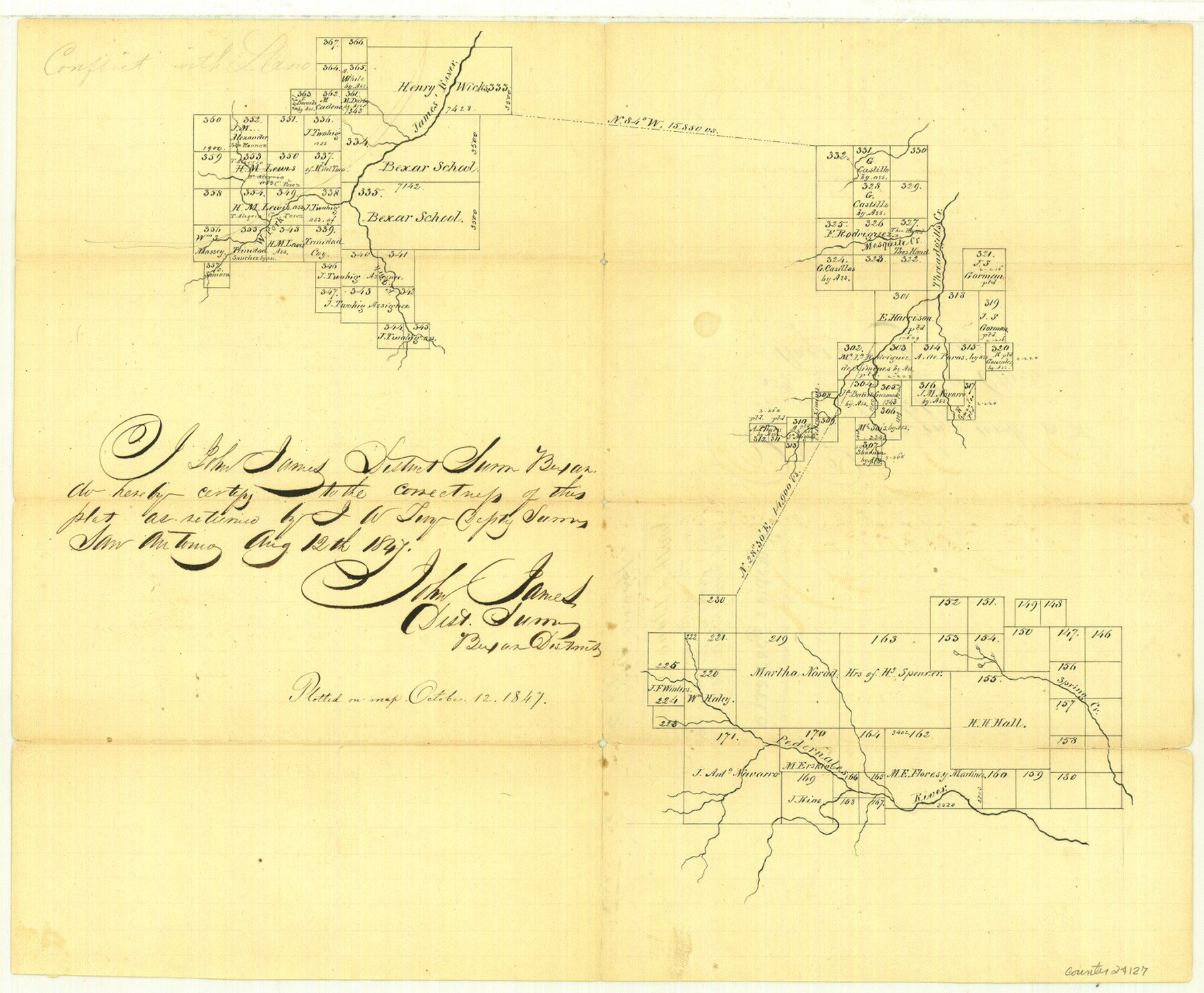
[Sketch south of Llano along James River, Threadgill's Creek and Pedernales River]
-
Map/Doc
24127
-
Collection
General Map Collection
-
Object Dates
1847/10/12 (File Date)
1847/8/12 (Creation Date)
-
People and Organizations
John James (Surveyor/Engineer)
J.W. Tivy (Surveyor/Engineer)
Mr. Creusbaur (Draftsman)
-
Counties
Gillespie Mason Kimble
-
Subjects
Surveying Sketch File
-
Height x Width
12.8 x 15.5 inches
32.5 x 39.4 cm
-
Medium
paper, manuscript
-
Features
James River
West Fork of James River
East Fork of James River
Threadgill's Creek
Mesquite Creek
Pedernales River
Spring Creek
Part of: General Map Collection
Flight Mission No. DAG-17K, Frame 142, Matagorda County

Print $20.00
- Digital $50.00
Flight Mission No. DAG-17K, Frame 142, Matagorda County
1952
Size 16.4 x 16.3 inches
Map/Doc 86359
Travis County Working Sketch 5

Print $20.00
- Digital $50.00
Travis County Working Sketch 5
1910
Size 28.3 x 20.7 inches
Map/Doc 69389
Jim Hogg County Rolled Sketch F

Print $20.00
- Digital $50.00
Jim Hogg County Rolled Sketch F
1930
Size 24.5 x 28.9 inches
Map/Doc 6445
DeWitt County

Print $40.00
- Digital $50.00
DeWitt County
1987
Size 42.6 x 53.2 inches
Map/Doc 73131
Lee County Boundary File 2

Print $25.00
- Digital $50.00
Lee County Boundary File 2
Size 14.2 x 8.6 inches
Map/Doc 56269
Culberson County Rolled Sketch 48

Print $335.00
- Digital $50.00
Culberson County Rolled Sketch 48
1960
Size 11.0 x 15.4 inches
Map/Doc 45339
Current Miscellaneous File 20

Print $22.00
- Digital $50.00
Current Miscellaneous File 20
1952
Size 10.7 x 8.1 inches
Map/Doc 73855
Midland County Working Sketch Graphic Index

Print $20.00
- Digital $50.00
Midland County Working Sketch Graphic Index
1930
Size 43.3 x 35.3 inches
Map/Doc 76641
Layout of the porciones as described in the Visita General of Reynosa, 1767

Layout of the porciones as described in the Visita General of Reynosa, 1767
2009
Size 11.0 x 8.5 inches
Map/Doc 94045
Coryell County Rolled Sketch 1

Print $20.00
- Digital $50.00
Coryell County Rolled Sketch 1
1943
Size 22.7 x 21.4 inches
Map/Doc 5565
Flight Mission No. DQN-1K, Frame 73, Calhoun County

Print $20.00
- Digital $50.00
Flight Mission No. DQN-1K, Frame 73, Calhoun County
1953
Size 18.5 x 22.2 inches
Map/Doc 84160
Travis County Rolled Sketch 43

Print $20.00
- Digital $50.00
Travis County Rolled Sketch 43
1962
Size 27.3 x 22.7 inches
Map/Doc 8041
You may also like
Dimmit County

Print $40.00
- Digital $50.00
Dimmit County
1976
Size 43.2 x 51.7 inches
Map/Doc 95483
Presidio County Sketch File 53

Print $24.00
- Digital $50.00
Presidio County Sketch File 53
1928
Size 16.6 x 8.8 inches
Map/Doc 34610
Val Verde County Working Sketch 87

Print $20.00
- Digital $50.00
Val Verde County Working Sketch 87
1973
Size 37.1 x 33.8 inches
Map/Doc 72222
Edwards County Rolled Sketch 16A

Print $20.00
- Digital $50.00
Edwards County Rolled Sketch 16A
1944
Size 25.0 x 19.0 inches
Map/Doc 5805
The Republic County of Montgomery. Created, December 14, 1837

Print $20.00
The Republic County of Montgomery. Created, December 14, 1837
2020
Size 19.9 x 21.7 inches
Map/Doc 96234
Winkler County Sketch File 3

Print $20.00
- Digital $50.00
Winkler County Sketch File 3
Size 38.6 x 33.8 inches
Map/Doc 10436
Railroad and County Map of Texas

Print $20.00
- Digital $50.00
Railroad and County Map of Texas
1887
Size 18.0 x 23.9 inches
Map/Doc 93959
Mrs. R. L. Westerman Subdivision of 2 1/2 Acres out of North Half of Survey Number 1, Block Number 36, Township 5 North. Dawson County, Texas

Print $20.00
- Digital $50.00
Mrs. R. L. Westerman Subdivision of 2 1/2 Acres out of North Half of Survey Number 1, Block Number 36, Township 5 North. Dawson County, Texas
1924
Size 18.6 x 24.5 inches
Map/Doc 92591
Crockett County Sketch File 75a

Print $6.00
- Digital $50.00
Crockett County Sketch File 75a
Size 14.2 x 8.8 inches
Map/Doc 19873
Eastland County Rolled Sketch B

Print $20.00
- Digital $50.00
Eastland County Rolled Sketch B
1893
Size 27.7 x 40.9 inches
Map/Doc 5774
Somervell County Working Sketch 6

Print $20.00
- Digital $50.00
Somervell County Working Sketch 6
1992
Size 23.2 x 21.5 inches
Map/Doc 63910
Zavala County

Print $40.00
- Digital $50.00
Zavala County
1977
Size 43.6 x 49.3 inches
Map/Doc 95684