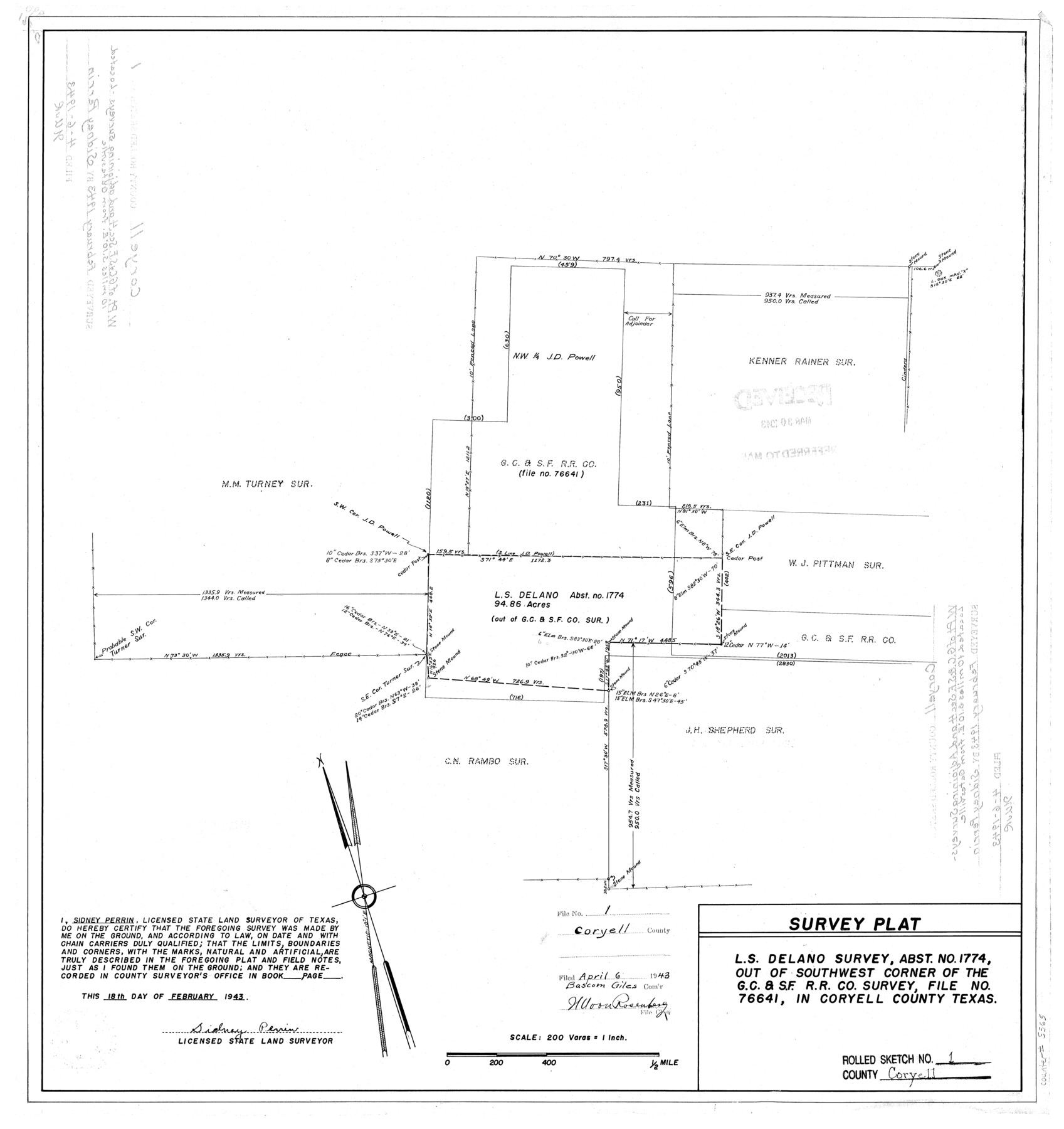
Coryell County Rolled Sketch 1
Survey plat, L.S. Delano survey, abst. no. 1774, out of southwest corner of the G. C. & S. F. R.R. Co. survey, file no. 76641
-
Map/Doc
5565
-
Collection
General Map Collection
-
Object Dates
1943/2/18 (Creation Date)
1943/4/6 (File Date)
-
People and Organizations
Sidney Perrin (Surveyor/Engineer)
-
Counties
Coryell
-
Subjects
Surveying Rolled Sketch
-
Height x Width
22.7 x 21.4 inches
57.7 x 54.4 cm
-
Scale
1" = 200 varas
Part of: General Map Collection
Hale County Sketch File 6

Print $20.00
- Digital $50.00
Hale County Sketch File 6
Size 41.9 x 35.5 inches
Map/Doc 10468
Duval County Working Sketch 6

Print $20.00
- Digital $50.00
Duval County Working Sketch 6
1935
Size 26.9 x 21.8 inches
Map/Doc 68719
Loving County Sketch File 9

Print $36.00
- Digital $50.00
Loving County Sketch File 9
2015
Size 14.0 x 8.5 inches
Map/Doc 93794
Bell County Sketch File 26a

Print $4.00
- Digital $50.00
Bell County Sketch File 26a
1883
Size 9.0 x 9.6 inches
Map/Doc 14433
Flight Mission No. BRE-1P, Frame 55, Nueces County

Print $20.00
- Digital $50.00
Flight Mission No. BRE-1P, Frame 55, Nueces County
1956
Size 18.3 x 22.2 inches
Map/Doc 86644
Val Verde County Rolled Sketch 59

Print $20.00
- Digital $50.00
Val Verde County Rolled Sketch 59
1947
Size 45.2 x 23.6 inches
Map/Doc 10078

Wichita County Rolled Sketch 9

Print $20.00
- Digital $50.00
Wichita County Rolled Sketch 9
1917
Size 28.0 x 27.7 inches
Map/Doc 8246
Bandera County Working Sketch 49

Print $20.00
- Digital $50.00
Bandera County Working Sketch 49
1983
Size 28.2 x 43.3 inches
Map/Doc 67645
Map of Stephens County

Print $20.00
- Digital $50.00
Map of Stephens County
1897
Size 43.0 x 37.3 inches
Map/Doc 78395
[Nueces Bay, Mustang Island and Padre Island]
![73466, [Nueces Bay, Mustang Island and Padre Island], General Map Collection](https://historictexasmaps.com/wmedia_w700/maps/73466.tif.jpg)
Print $4.00
- Digital $50.00
[Nueces Bay, Mustang Island and Padre Island]
Size 18.3 x 25.3 inches
Map/Doc 73466
Milam County Texas

Print $20.00
- Digital $50.00
Milam County Texas
1879
Size 26.7 x 23.1 inches
Map/Doc 3879
You may also like
[Corner of Blocks H1, K5, Z3, S, and Block 8]
![91470, [Corner of Blocks H1, K5, Z3, S, and Block 8], Twichell Survey Records](https://historictexasmaps.com/wmedia_w700/maps/91470-1.tif.jpg)
Print $3.00
- Digital $50.00
[Corner of Blocks H1, K5, Z3, S, and Block 8]
Size 11.9 x 14.6 inches
Map/Doc 91470
General Highway Map. Detail of Cities and Towns in Dallas County, Texas [Dallas and vicinity]
![79070, General Highway Map. Detail of Cities and Towns in Dallas County, Texas [Dallas and vicinity], Texas State Library and Archives](https://historictexasmaps.com/wmedia_w700/maps/79070.tif.jpg)
Print $20.00
General Highway Map. Detail of Cities and Towns in Dallas County, Texas [Dallas and vicinity]
1936
Size 18.4 x 25.1 inches
Map/Doc 79070

Appletons' Railway Map of the Southern States, to accompany Appletons' Hand-book of American Travel, Southern Tour

Print $20.00
- Digital $50.00
Appletons' Railway Map of the Southern States, to accompany Appletons' Hand-book of American Travel, Southern Tour
1887
Size 15.6 x 24.3 inches
Map/Doc 95904
Brazos River, Brazos River Sheet 6

Print $20.00
- Digital $50.00
Brazos River, Brazos River Sheet 6
1926
Size 27.9 x 23.0 inches
Map/Doc 69670
Wharton County Working Sketch 18

Print $20.00
- Digital $50.00
Wharton County Working Sketch 18
1948
Size 19.3 x 17.0 inches
Map/Doc 72482
Flight Mission No. DQO-11K, Frame 27, Galveston County

Print $20.00
- Digital $50.00
Flight Mission No. DQO-11K, Frame 27, Galveston County
1952
Size 18.8 x 22.4 inches
Map/Doc 85224
General Highway Map, Nacogdoches County, Texas

Print $20.00
General Highway Map, Nacogdoches County, Texas
1940
Size 18.5 x 24.7 inches
Map/Doc 79205
Starr County Working Sketch 7

Print $20.00
- Digital $50.00
Starr County Working Sketch 7
1938
Size 39.2 x 36.4 inches
Map/Doc 63923
Flight Mission No. DAG-21K, Frame 36, Matagorda County

Print $20.00
- Digital $50.00
Flight Mission No. DAG-21K, Frame 36, Matagorda County
1952
Size 18.5 x 22.3 inches
Map/Doc 86403
Leon County Working Sketch 28

Print $20.00
- Digital $50.00
Leon County Working Sketch 28
1971
Size 25.0 x 30.1 inches
Map/Doc 70427
Bexar County Rolled Sketch 4

Print $20.00
- Digital $50.00
Bexar County Rolled Sketch 4
Size 24.3 x 36.8 inches
Map/Doc 5137