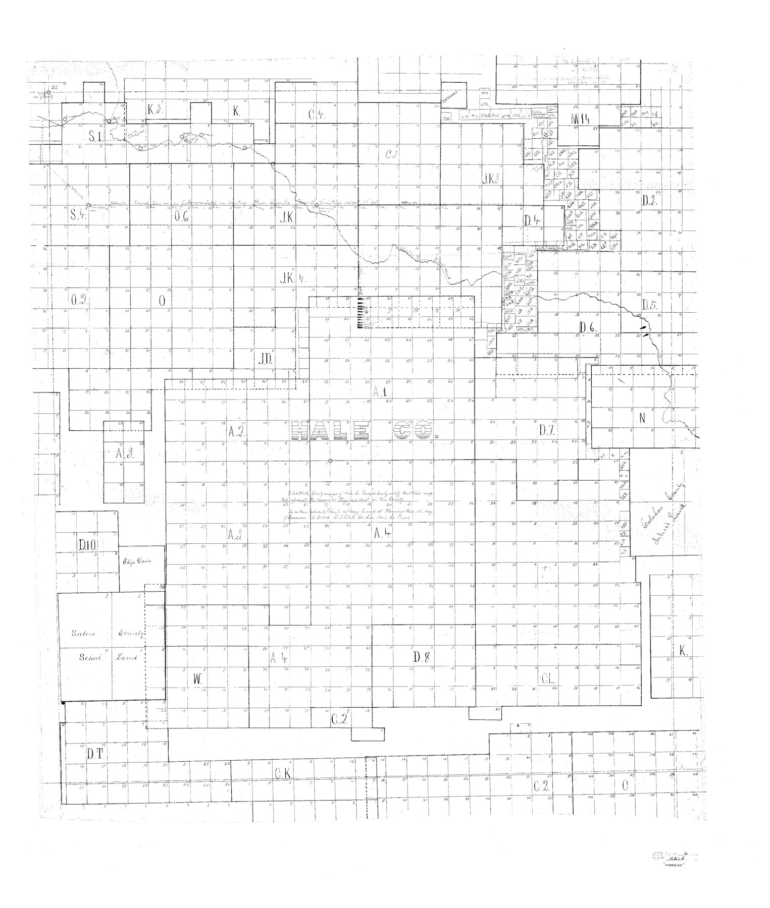
Hale County Sketch File 6
Plain Sk. of Surv. in Hale Co.
-
Map/Doc
10468
-
Collection
General Map Collection
-
Object Dates
1893/1/17 (File Date)
1892 (Survey Date)
-
People and Organizations
Jonathan Summerfield (Surveyor/Engineer)
L.A. White (Surveyor/Engineer)
-
Counties
Hale Castro Swisher Floyd Lubbock Lamb
-
Subjects
Surveying Sketch File
-
Height x Width
41.9 x 35.5 inches
106.4 x 90.2 cm
-
Medium
paper, photocopy
-
Features
White River Draw
Part of: General Map Collection
Gaines County Rolled Sketch 12

Print $20.00
- Digital $50.00
Gaines County Rolled Sketch 12
1940
Size 26.4 x 33.5 inches
Map/Doc 5933
Map of Washington County

Print $20.00
- Digital $50.00
Map of Washington County
1841
Size 18.9 x 27.1 inches
Map/Doc 4126
Map showing surveys made on Mustang Island

Print $40.00
- Digital $50.00
Map showing surveys made on Mustang Island
1945
Size 54.7 x 21.0 inches
Map/Doc 2948
Webb County Working Sketch 66

Print $40.00
- Digital $50.00
Webb County Working Sketch 66
1966
Size 62.8 x 42.5 inches
Map/Doc 72433

Presidio County Working Sketch 6

Print $20.00
- Digital $50.00
Presidio County Working Sketch 6
1920
Size 19.1 x 37.2 inches
Map/Doc 71680
Presidio County Sketch File 68

Print $4.00
- Digital $50.00
Presidio County Sketch File 68
1941
Size 11.2 x 8.8 inches
Map/Doc 34662
Sabine and Neches Rivers

Print $20.00
- Digital $50.00
Sabine and Neches Rivers
1971
Size 19.7 x 44.4 inches
Map/Doc 69817
Midland County Working Sketch 24

Print $40.00
- Digital $50.00
Midland County Working Sketch 24
1957
Size 42.9 x 80.9 inches
Map/Doc 71005
[Galveston, Harrisburg & San Antonio through El Paso County]
![64010, [Galveston, Harrisburg & San Antonio through El Paso County], General Map Collection](https://historictexasmaps.com/wmedia_w700/maps/64010.tif.jpg)
Print $20.00
- Digital $50.00
[Galveston, Harrisburg & San Antonio through El Paso County]
1906
Size 13.4 x 33.9 inches
Map/Doc 64010
Upshur County Sketch File 22

Print $8.00
- Digital $50.00
Upshur County Sketch File 22
2015
Size 11.0 x 8.5 inches
Map/Doc 93774
Map No. 8-A, Calhoun Co. - Revision of the East portion of Espiritu Santo Bay Tracts

Print $5.00
- Digital $50.00
Map No. 8-A, Calhoun Co. - Revision of the East portion of Espiritu Santo Bay Tracts
1978
Size 21.2 x 28.0 inches
Map/Doc 2498
You may also like
Shelby County Working Sketch 27

Print $20.00
- Digital $50.00
Shelby County Working Sketch 27
1995
Size 32.8 x 39.9 inches
Map/Doc 63881
Louisiana and Texas Intracoastal Waterway

Print $20.00
- Digital $50.00
Louisiana and Texas Intracoastal Waterway
1929
Size 13.8 x 19.7 inches
Map/Doc 83340
Deaf Smith County Rolled Sketch 1

Print $20.00
- Digital $50.00
Deaf Smith County Rolled Sketch 1
1965
Size 24.8 x 25.9 inches
Map/Doc 5698
Map of Portion of the Gulf of Mexico Adjoining Jefferson County Showing Subdivision Thereof for Mineral Development

Print $20.00
- Digital $50.00
Map of Portion of the Gulf of Mexico Adjoining Jefferson County Showing Subdivision Thereof for Mineral Development
1940
Size 17.7 x 20.2 inches
Map/Doc 3018
General Highway Map. Detail of Cities and Towns in Jefferson County, Texas. City Map of Port Arthur and vicinity, Jefferson County, Texas

Print $20.00
General Highway Map. Detail of Cities and Towns in Jefferson County, Texas. City Map of Port Arthur and vicinity, Jefferson County, Texas
1961
Size 18.0 x 24.7 inches
Map/Doc 79540
Refugio County Sketch File 3

Print $8.00
- Digital $50.00
Refugio County Sketch File 3
1849
Size 12.9 x 8.6 inches
Map/Doc 35241
Galveston County NRC Article 33.136 Sketch 35

Print $42.00
- Digital $50.00
Galveston County NRC Article 33.136 Sketch 35
2005
Size 24.3 x 36.6 inches
Map/Doc 83406
Val Verde County Working Sketch 5

Print $20.00
- Digital $50.00
Val Verde County Working Sketch 5
1909
Size 13.0 x 29.8 inches
Map/Doc 72140
Edwards County Working Sketch 109

Print $40.00
- Digital $50.00
Edwards County Working Sketch 109
1972
Size 51.8 x 37.6 inches
Map/Doc 68985
McMullen County Sketch File 37

Print $6.00
- Digital $50.00
McMullen County Sketch File 37
1937
Size 14.3 x 8.8 inches
Map/Doc 31410
Houston County Working Sketch 28

Print $20.00
- Digital $50.00
Houston County Working Sketch 28
1988
Size 30.2 x 37.8 inches
Map/Doc 66258
Nueces County Working Sketch 4

Print $20.00
- Digital $50.00
Nueces County Working Sketch 4
1951
Size 46.8 x 36.2 inches
Map/Doc 71306