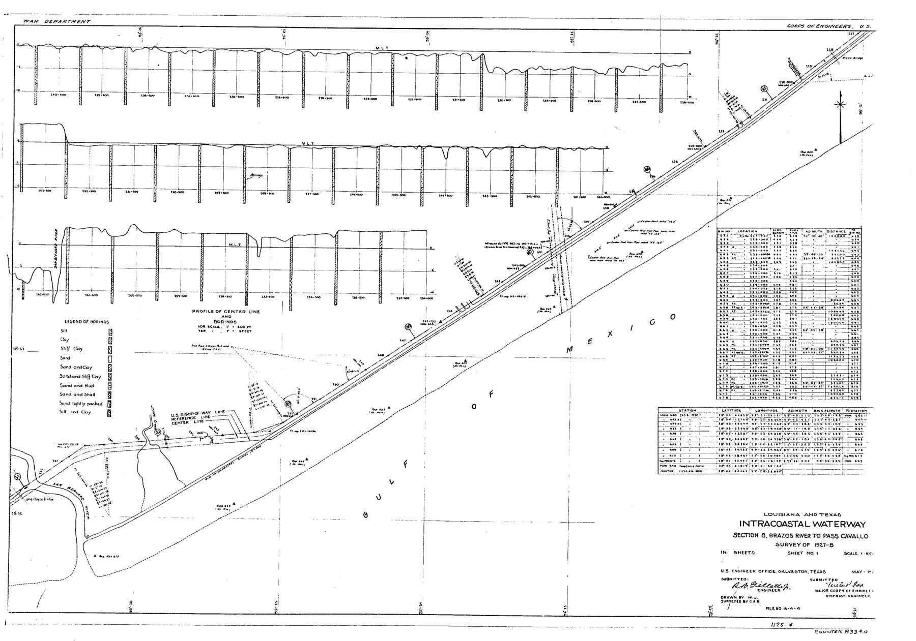
Louisiana and Texas Intracoastal Waterway
-
Map/Doc
83340
-
Collection
General Map Collection
-
Object Dates
1929 (Creation Date)
-
People and Organizations
Corps of Engineers (Publisher)
Corps of Engineers (Printer)
W.J. (Draftsman)
C.A.R. (Surveyor/Engineer)
-
Counties
Brazoria
-
Subjects
Intracoastal Waterways Nautical Charts
-
Height x Width
13.8 x 19.7 inches
35.1 x 50.0 cm
Part of: General Map Collection
Taylor County Rolled Sketch 27A

Print $20.00
- Digital $50.00
Taylor County Rolled Sketch 27A
Size 30.5 x 21.4 inches
Map/Doc 7919
Sutton County Boundary File 5a

Print $20.00
- Digital $50.00
Sutton County Boundary File 5a
Size 14.5 x 8.9 inches
Map/Doc 59060

Presidio County Working Sketch 9a

Print $20.00
- Digital $50.00
Presidio County Working Sketch 9a
1933
Size 22.3 x 16.7 inches
Map/Doc 78284
Bandera County Working Sketch 33

Print $20.00
- Digital $50.00
Bandera County Working Sketch 33
1961
Size 22.4 x 28.8 inches
Map/Doc 67629
Wichita County Sketch File 17

Print $20.00
- Digital $50.00
Wichita County Sketch File 17
1889
Size 29.7 x 22.4 inches
Map/Doc 12680
Brazos River, Brazos River Sheet 1

Print $20.00
- Digital $50.00
Brazos River, Brazos River Sheet 1
1926
Size 20.7 x 25.3 inches
Map/Doc 69665
La Salle County Working Sketch 7

Print $20.00
- Digital $50.00
La Salle County Working Sketch 7
1922
Size 35.0 x 36.5 inches
Map/Doc 70308
Milam County Rolled Sketch 5A

Print $20.00
- Digital $50.00
Milam County Rolled Sketch 5A
1997
Size 28.0 x 39.8 inches
Map/Doc 6778
Nolan County Working Sketch 6

Print $20.00
- Digital $50.00
Nolan County Working Sketch 6
1950
Size 27.2 x 26.0 inches
Map/Doc 71297
Val Verde County Working Sketch 9

Print $20.00
- Digital $50.00
Val Verde County Working Sketch 9
1917
Size 19.4 x 30.9 inches
Map/Doc 72144
Travis County Sketch File 2

Print $4.00
- Digital $50.00
Travis County Sketch File 2
1851
Size 8.2 x 9.9 inches
Map/Doc 38271
You may also like
City of Round Rock, Texas

Print $20.00
City of Round Rock, Texas
1958
Size 25.3 x 31.5 inches
Map/Doc 87359
Map of section no. 4 of a survey of Padre Island made for the Office of the Attorney General of the State of Texas

Print $40.00
- Digital $50.00
Map of section no. 4 of a survey of Padre Island made for the Office of the Attorney General of the State of Texas
1941
Size 82.6 x 40.8 inches
Map/Doc 2260
Map of the Recognised Line, M. El. P. & P. RR. from Texas & Arkansas State Line to Milam & Bexar Land District Line

Print $40.00
- Digital $50.00
Map of the Recognised Line, M. El. P. & P. RR. from Texas & Arkansas State Line to Milam & Bexar Land District Line
Size 15.3 x 89.4 inches
Map/Doc 64638
Crane County Rolled Sketch 4

Print $40.00
- Digital $50.00
Crane County Rolled Sketch 4
Size 34.7 x 51.9 inches
Map/Doc 8337
Freestone County Working Sketch 34

Print $40.00
- Digital $50.00
Freestone County Working Sketch 34
2011
Size 36.5 x 59.2 inches
Map/Doc 90095
[Beaumont, Sour Lake and Western Ry. Right of Way and Alignment - Frisco]
![64121, [Beaumont, Sour Lake and Western Ry. Right of Way and Alignment - Frisco], General Map Collection](https://historictexasmaps.com/wmedia_w700/maps/64121.tif.jpg)
Print $20.00
- Digital $50.00
[Beaumont, Sour Lake and Western Ry. Right of Way and Alignment - Frisco]
1910
Size 20.0 x 45.8 inches
Map/Doc 64121
Webb County Rolled Sketch 78A

Print $20.00
- Digital $50.00
Webb County Rolled Sketch 78A
Size 28.4 x 23.0 inches
Map/Doc 90053
Hays County Rolled Sketch 20

Print $20.00
- Digital $50.00
Hays County Rolled Sketch 20
Size 14.1 x 36.9 inches
Map/Doc 6176
Railroad Track Map, T&PRRCo., Culberson County, Texas

Print $4.00
- Digital $50.00
Railroad Track Map, T&PRRCo., Culberson County, Texas
1910
Size 11.8 x 18.6 inches
Map/Doc 62828
Crane County Rolled Sketch 9

Print $20.00
- Digital $50.00
Crane County Rolled Sketch 9
1930
Size 29.6 x 35.0 inches
Map/Doc 5573
Sketch in Crockett County, Texas

Print $20.00
- Digital $50.00
Sketch in Crockett County, Texas
Size 39.5 x 34.1 inches
Map/Doc 92555
Ward County Working Sketch 7

Print $20.00
- Digital $50.00
Ward County Working Sketch 7
1946
Size 24.0 x 22.6 inches
Map/Doc 72313