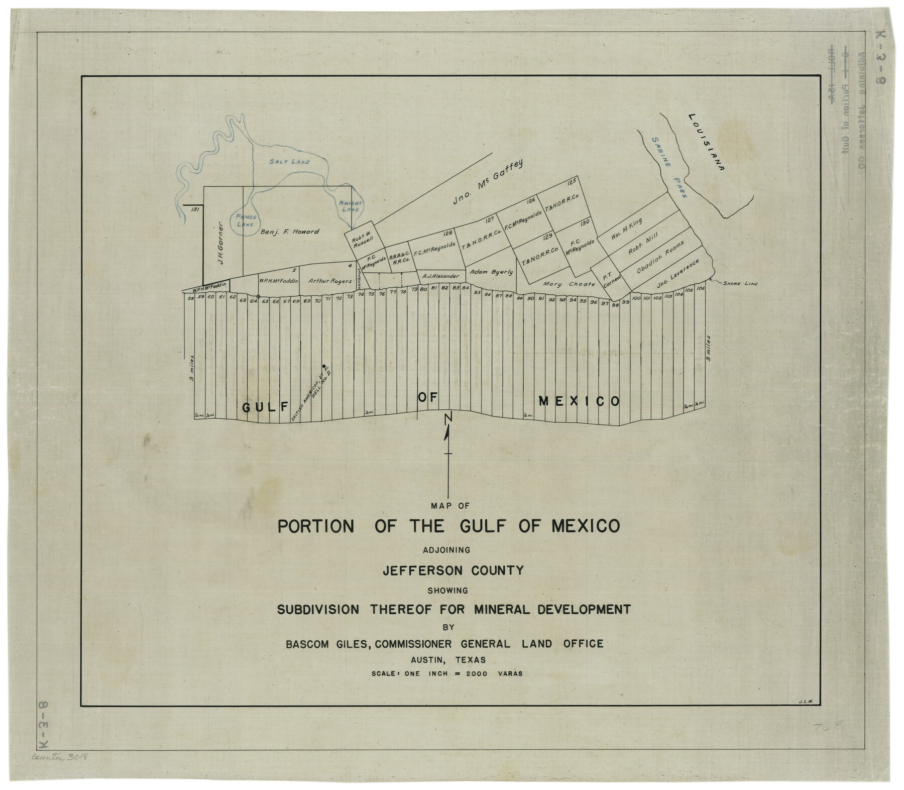
Map of Portion of the Gulf of Mexico Adjoining Jefferson County Showing Subdivision Thereof for Mineral Development
K-3-8
-
Map/Doc
3018
-
Collection
General Map Collection
-
Object Dates
1940 (Creation Date)
-
Counties
Jefferson
-
Subjects
Energy Offshore Submerged Area
-
Height x Width
17.7 x 20.2 inches
45.0 x 51.3 cm
Part of: General Map Collection
Flight Mission No. CRC-1R, Frame 155, Chambers County

Print $20.00
- Digital $50.00
Flight Mission No. CRC-1R, Frame 155, Chambers County
1956
Size 18.8 x 22.4 inches
Map/Doc 84717
United States - Gulf Coast - Galveston to Rio Grande

Print $20.00
- Digital $50.00
United States - Gulf Coast - Galveston to Rio Grande
1940
Size 27.0 x 18.2 inches
Map/Doc 72755
Map of the Fort Worth & Denver City Railway

Print $40.00
- Digital $50.00
Map of the Fort Worth & Denver City Railway
1887
Size 19.9 x 57.9 inches
Map/Doc 64477
Harris County Historic Topographic 3

Print $20.00
- Digital $50.00
Harris County Historic Topographic 3
1916
Size 29.4 x 22.5 inches
Map/Doc 65813
McMullen County Sketch File 27a

Print $4.00
- Digital $50.00
McMullen County Sketch File 27a
Size 9.5 x 6.3 inches
Map/Doc 31390
Armstrong County Working Sketch 3

Print $20.00
- Digital $50.00
Armstrong County Working Sketch 3
1904
Size 46.1 x 40.8 inches
Map/Doc 67234
Jasper County Rolled Sketch 1

Print $20.00
- Digital $50.00
Jasper County Rolled Sketch 1
Size 17.0 x 18.9 inches
Map/Doc 6346
United States - Gulf Coast - Padre I. and Laguna Madre Lat. 27° 12' to Lat. 26° 33' Texas

Print $20.00
- Digital $50.00
United States - Gulf Coast - Padre I. and Laguna Madre Lat. 27° 12' to Lat. 26° 33' Texas
1913
Size 27.1 x 18.3 inches
Map/Doc 72816
Kaufman County Sketch File 20

Print $20.00
- Digital $50.00
Kaufman County Sketch File 20
1950
Size 23.2 x 34.8 inches
Map/Doc 11908
Val Verde County Working Sketch 30

Print $20.00
- Digital $50.00
Val Verde County Working Sketch 30
1938
Size 37.9 x 28.5 inches
Map/Doc 72165
Reeves County Sketch File 9

Print $20.00
- Digital $50.00
Reeves County Sketch File 9
Size 46.3 x 38.2 inches
Map/Doc 10587
Briscoe County Sketch File 14a

Print $6.00
- Digital $50.00
Briscoe County Sketch File 14a
Size 14.3 x 8.6 inches
Map/Doc 16519
You may also like
Coke County Working Sketch 12

Print $20.00
- Digital $50.00
Coke County Working Sketch 12
1947
Size 36.7 x 45.6 inches
Map/Doc 68049
Flight Mission No. CGI-4N, Frame 160, Cameron County

Print $20.00
- Digital $50.00
Flight Mission No. CGI-4N, Frame 160, Cameron County
1955
Size 18.5 x 22.3 inches
Map/Doc 84668
Flight Mission No. DQN-6K, Frame 12, Calhoun County

Print $20.00
- Digital $50.00
Flight Mission No. DQN-6K, Frame 12, Calhoun County
1953
Size 18.6 x 22.2 inches
Map/Doc 84434
Hudspeth County Working Sketch 10

Print $20.00
- Digital $50.00
Hudspeth County Working Sketch 10
1941
Size 16.0 x 17.1 inches
Map/Doc 66291
[Northern Bexar District]
![1963, [Northern Bexar District], General Map Collection](https://historictexasmaps.com/wmedia_w700/maps/1963-1.tif.jpg)
Print $20.00
- Digital $50.00
[Northern Bexar District]
1852
Size 46.0 x 26.5 inches
Map/Doc 1963
General Highway Map, Mitchell County, Texas

Print $20.00
General Highway Map, Mitchell County, Texas
1940
Size 18.5 x 24.8 inches
Map/Doc 79200
[Sketch showing B. S. & F. survey number 9, section 9]
![91711, [Sketch showing B. S. & F. survey number 9, section 9], Twichell Survey Records](https://historictexasmaps.com/wmedia_w700/maps/91711-1.tif.jpg)
Print $2.00
- Digital $50.00
[Sketch showing B. S. & F. survey number 9, section 9]
Size 8.7 x 8.1 inches
Map/Doc 91711
Topographical Map of the country between San Antonio & Colorado Rivers in the State of Texas.

Print $40.00
Topographical Map of the country between San Antonio & Colorado Rivers in the State of Texas.
1864
Size 53.3 x 69.2 inches
Map/Doc 88604
Crockett County Working Sketch 36

Print $20.00
- Digital $50.00
Crockett County Working Sketch 36
1927
Size 22.4 x 26.0 inches
Map/Doc 68369
Atascosa County Sketch File 4

Print $7.00
- Digital $50.00
Atascosa County Sketch File 4
1854
Size 8.1 x 6.5 inches
Map/Doc 13745
Liberty County Working Sketch 54

Print $20.00
- Digital $50.00
Liberty County Working Sketch 54
1962
Size 29.8 x 29.5 inches
Map/Doc 70514
Reagan County Rolled Sketch 15

Print $20.00
- Digital $50.00
Reagan County Rolled Sketch 15
Size 16.7 x 22.7 inches
Map/Doc 7443