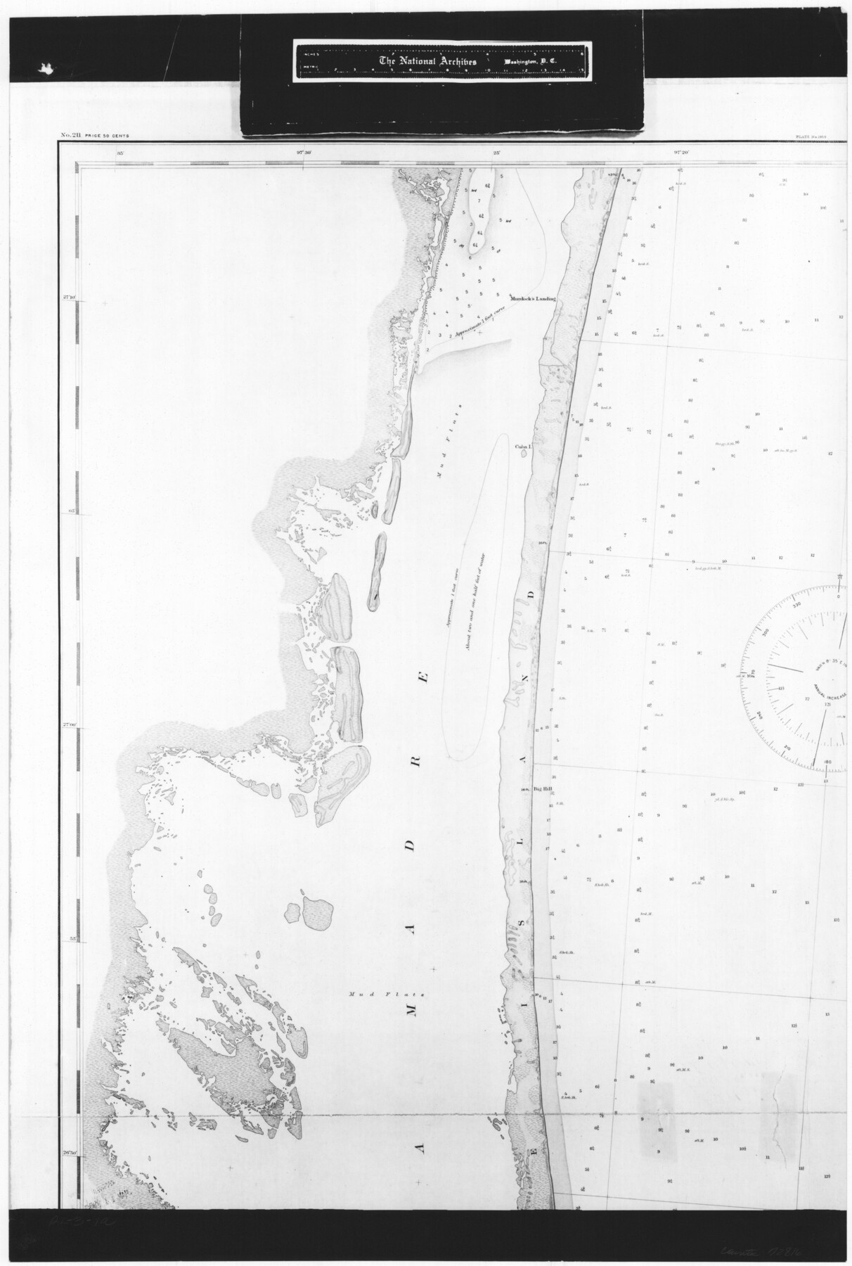
United States - Gulf Coast - Padre I. and Laguna Madre Lat. 27° 12' to Lat. 26° 33' Texas
RL-3-1a
-
Map/Doc
72816
-
Collection
General Map Collection
-
Object Dates
1913 (Creation Date)
-
People and Organizations
Coastal and Geodetic Survey (Publisher)
U. S. Engineers (Surveyor/Engineer)
-
Counties
Nueces
-
Subjects
Nautical Charts
-
Height x Width
27.1 x 18.3 inches
68.8 x 46.5 cm
-
Comments
B/W photostat copy from National Archives in multiple pieces.
Part of: General Map Collection
Galveston County NRC Article 33.136 Location Key Sheet

Print $20.00
- Digital $50.00
Galveston County NRC Article 33.136 Location Key Sheet
1994
Size 27.0 x 21.8 inches
Map/Doc 77024
Pecos County Boundary File 1

Print $2.00
- Digital $50.00
Pecos County Boundary File 1
Size 10.1 x 8.0 inches
Map/Doc 57854
[Sketch for Mineral Application 26501 - Sabine River, T. A. Oldhausen]
![2843, [Sketch for Mineral Application 26501 - Sabine River, T. A. Oldhausen], General Map Collection](https://historictexasmaps.com/wmedia_w700/maps/2843.tif.jpg)
Print $20.00
- Digital $50.00
[Sketch for Mineral Application 26501 - Sabine River, T. A. Oldhausen]
1931
Size 23.8 x 36.2 inches
Map/Doc 2843
[Sketch for M-12871 to M-13240 - Presidio County]
![65649, [Sketch for M-12871 to M-13240 - Presidio County], General Map Collection](https://historictexasmaps.com/wmedia_w700/maps/65649.tif.jpg)
Print $20.00
- Digital $50.00
[Sketch for M-12871 to M-13240 - Presidio County]
1927
Size 33.0 x 30.5 inches
Map/Doc 65649
United States and Additions, 1820

Print $20.00
- Digital $50.00
United States and Additions, 1820
1820
Size 21.8 x 27.0 inches
Map/Doc 93798
Carte Generale des Treize Etats-Unis de l'Amerique Septentrionale

Print $20.00
- Digital $50.00
Carte Generale des Treize Etats-Unis de l'Amerique Septentrionale
1783
Size 22.9 x 27.0 inches
Map/Doc 93678
Ellis County Sketch File 15

Print $40.00
- Digital $50.00
Ellis County Sketch File 15
1861
Size 15.7 x 12.5 inches
Map/Doc 21856
Campbell's Addition to El Paso, Texas

Print $20.00
- Digital $50.00
Campbell's Addition to El Paso, Texas
1885
Size 43.5 x 43.1 inches
Map/Doc 8854
Dimmit County Sketch File 10

Print $20.00
- Digital $50.00
Dimmit County Sketch File 10
Size 23.5 x 22.6 inches
Map/Doc 11338
Port Aransas-Corpus Christi Waterway, Texas, Avery Point Turning Basin to Vicinity of Tule Lake - Dredging

Print $20.00
- Digital $50.00
Port Aransas-Corpus Christi Waterway, Texas, Avery Point Turning Basin to Vicinity of Tule Lake - Dredging
1947
Size 28.5 x 41.4 inches
Map/Doc 60301
Comal County Working Sketch 13

Print $20.00
- Digital $50.00
Comal County Working Sketch 13
1988
Size 32.6 x 21.3 inches
Map/Doc 68179
Flight Mission No. CGI-2N, Frame 153, Cameron County

Print $20.00
- Digital $50.00
Flight Mission No. CGI-2N, Frame 153, Cameron County
1954
Size 18.8 x 22.3 inches
Map/Doc 84535
You may also like
Polk County Working Sketch 40

Print $20.00
- Digital $50.00
Polk County Working Sketch 40
1983
Size 25.4 x 27.3 inches
Map/Doc 71657
Blanco County Sketch File 33

Print $4.00
- Digital $50.00
Blanco County Sketch File 33
Size 7.9 x 7.0 inches
Map/Doc 14635
Swisher County Sketch File 9

Print $4.00
- Digital $50.00
Swisher County Sketch File 9
1916
Size 11.2 x 8.7 inches
Map/Doc 37629
Matagorda County Rolled Sketch 18

Print $20.00
- Digital $50.00
Matagorda County Rolled Sketch 18
1838
Size 35.7 x 30.8 inches
Map/Doc 6685
Stonewall County Boundary File 2

Print $12.00
- Digital $50.00
Stonewall County Boundary File 2
Size 14.2 x 8.8 inches
Map/Doc 58955
Map of Grayson County

Print $20.00
- Digital $50.00
Map of Grayson County
1859
Size 22.6 x 19.5 inches
Map/Doc 3600
Culberson County Working Sketch 9

Print $20.00
- Digital $50.00
Culberson County Working Sketch 9
1915
Size 41.5 x 35.9 inches
Map/Doc 68461
Roberts County, State of Texas

Print $20.00
Roberts County, State of Texas
1888
Size 21.6 x 16.4 inches
Map/Doc 88990
Sketch Showing Division Fence, Shelton- Matador, Oldham County

Print $20.00
- Digital $50.00
Sketch Showing Division Fence, Shelton- Matador, Oldham County
Size 20.4 x 18.6 inches
Map/Doc 91445
Harris County Working Sketch 32

Print $20.00
- Digital $50.00
Harris County Working Sketch 32
1936
Size 34.7 x 41.8 inches
Map/Doc 65924
Pecos County Rolled Sketch 115A

Print $20.00
- Digital $50.00
Pecos County Rolled Sketch 115A
1943
Size 15.8 x 15.2 inches
Map/Doc 7258
Lamb County Sketch File 9

Print $4.00
- Digital $50.00
Lamb County Sketch File 9
1910
Size 10.9 x 7.2 inches
Map/Doc 29358