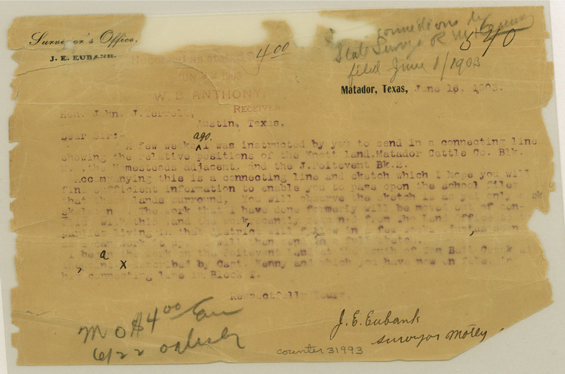
Motley County Sketch File 2D (N)
[Field notes of connecting lines in northeast part of county]
-
Map/Doc
31984
-
Collection
General Map Collection
-
Object Dates
6/16/1903 (Correspondence Date)
6/22/1903 (File Date)
5/28/1903 (Survey Date)
6/2/1903 (Survey Date)
11/9/1903 (Correspondence Date)
11/12/1903 (Correspondence Date)
-
People and Organizations
J.E. Eubank (Surveyor/Engineer)
Jerry Kelly (Chainman/Field Personnel)
W.M. Bethany (Chainman/Field Personnel)
George Blackshear (Chainman/Field Personnel)
I.E. Boren (Chainman/Field Personnel)
J.R. Williams (Chainman/Field Personnel)
E.S. Eubank (Chainman/Field Personnel)
John McAdams (Chainman/Field Personnel)
Amos Cook (Chainman/Field Personnel)
M.E. Ragsdale (Surveyor/Engineer)
M.K. Ragsdale (Surveyor/Engineer)
Capt. R.M. Kenney (Surveyor/Engineer)
J.B. Foster (Chainman/Field Personnel)
W.H. Denney (Chainman/Field Personnel)
-
Counties
Motley
-
Subjects
Surveying Sketch File
-
Height x Width
14.3 x 9.0 inches
36.3 x 22.9 cm
-
Medium
paper, print
-
Features
Tom Ball Creek
Connies Creek
Sisk Creek
South Pease River
Cotton Wood Creek
Quitaque River
Part of: General Map Collection
San Patricio County Working Sketch 25

Print $20.00
- Digital $50.00
San Patricio County Working Sketch 25
1951
Size 20.3 x 25.4 inches
Map/Doc 63787
San Augustine County Sketch File 12

Print $4.00
San Augustine County Sketch File 12
Size 12.2 x 7.9 inches
Map/Doc 35656
Shelby County Working Sketch 8

Print $20.00
- Digital $50.00
Shelby County Working Sketch 8
1942
Size 20.0 x 30.3 inches
Map/Doc 63861
Greater San Antonio & Surrounding Area

Greater San Antonio & Surrounding Area
Size 36.1 x 46.0 inches
Map/Doc 96869
Flight Mission No. DQO-3K, Frame 26, Galveston County

Print $20.00
- Digital $50.00
Flight Mission No. DQO-3K, Frame 26, Galveston County
1952
Size 17.4 x 18.9 inches
Map/Doc 85067
Northeast Part Pecos County

Print $20.00
- Digital $50.00
Northeast Part Pecos County
1975
Size 35.8 x 42.3 inches
Map/Doc 73260
Harris County Rolled Sketch 100

Print $20.00
- Digital $50.00
Harris County Rolled Sketch 100
2002
Size 24.2 x 36.9 inches
Map/Doc 77535
Eastland County Sketch File 12

Print $10.00
- Digital $50.00
Eastland County Sketch File 12
1879
Size 9.3 x 8.4 inches
Map/Doc 21588
Map of Upton County

Print $20.00
- Digital $50.00
Map of Upton County
1899
Size 47.3 x 41.1 inches
Map/Doc 16909
Presidio County Rolled Sketch 137

Print $20.00
- Digital $50.00
Presidio County Rolled Sketch 137
1999
Size 38.7 x 47.9 inches
Map/Doc 8352
A Map of Gonzales County

Print $20.00
- Digital $50.00
A Map of Gonzales County
1838
Size 34.7 x 39.2 inches
Map/Doc 16838
Chambers County Rolled Sketch CL

Print $40.00
- Digital $50.00
Chambers County Rolled Sketch CL
1909
Size 56.2 x 21.0 inches
Map/Doc 8610
You may also like

Guadalupe County Working Sketch 2

Print $20.00
- Digital $50.00
Guadalupe County Working Sketch 2
1925
Size 37.2 x 19.2 inches
Map/Doc 63311
The Republic County of Shelby. February 1, 1842

Print $20.00
The Republic County of Shelby. February 1, 1842
2020
Size 20.0 x 21.7 inches
Map/Doc 96283
Fannin County Sketch File 16

Print $4.00
- Digital $50.00
Fannin County Sketch File 16
1873
Size 8.1 x 10.3 inches
Map/Doc 22469
[Sketch for Mineral Application 15559 - Hutchinson County, Canadian River]
![65681, [Sketch for Mineral Application 15559 - Hutchinson County, Canadian River], General Map Collection](https://historictexasmaps.com/wmedia_w700/maps/65681-1.tif.jpg)
Print $20.00
- Digital $50.00
[Sketch for Mineral Application 15559 - Hutchinson County, Canadian River]
1926
Size 13.2 x 12.0 inches
Map/Doc 65681
Fannin County Sketch File 26

Print $4.00
- Digital $50.00
Fannin County Sketch File 26
1873
Size 8.5 x 10.3 inches
Map/Doc 22495
Flight Mission No. DIX-6P, Frame 190, Aransas County

Print $20.00
- Digital $50.00
Flight Mission No. DIX-6P, Frame 190, Aransas County
1956
Size 18.8 x 22.7 inches
Map/Doc 83852
Culberson County Working Sketch 43

Print $40.00
- Digital $50.00
Culberson County Working Sketch 43
1970
Size 52.4 x 38.0 inches
Map/Doc 68497
[Plainview with Highland Addition]
![92662, [Plainview with Highland Addition], Twichell Survey Records](https://historictexasmaps.com/wmedia_w700/maps/92662-1.tif.jpg)
Print $40.00
- Digital $50.00
[Plainview with Highland Addition]
Size 54.0 x 27.4 inches
Map/Doc 92662
Trinity County Sketch File 43

Print $40.00
- Digital $50.00
Trinity County Sketch File 43
1854
Size 19.2 x 23.6 inches
Map/Doc 12495
Starr County Sketch File 7

Print $20.00
- Digital $50.00
Starr County Sketch File 7
Size 25.4 x 20.8 inches
Map/Doc 12326
Big Lake Oil Field

Print $20.00
- Digital $50.00
Big Lake Oil Field
1924
Size 27.3 x 19.1 inches
Map/Doc 2420