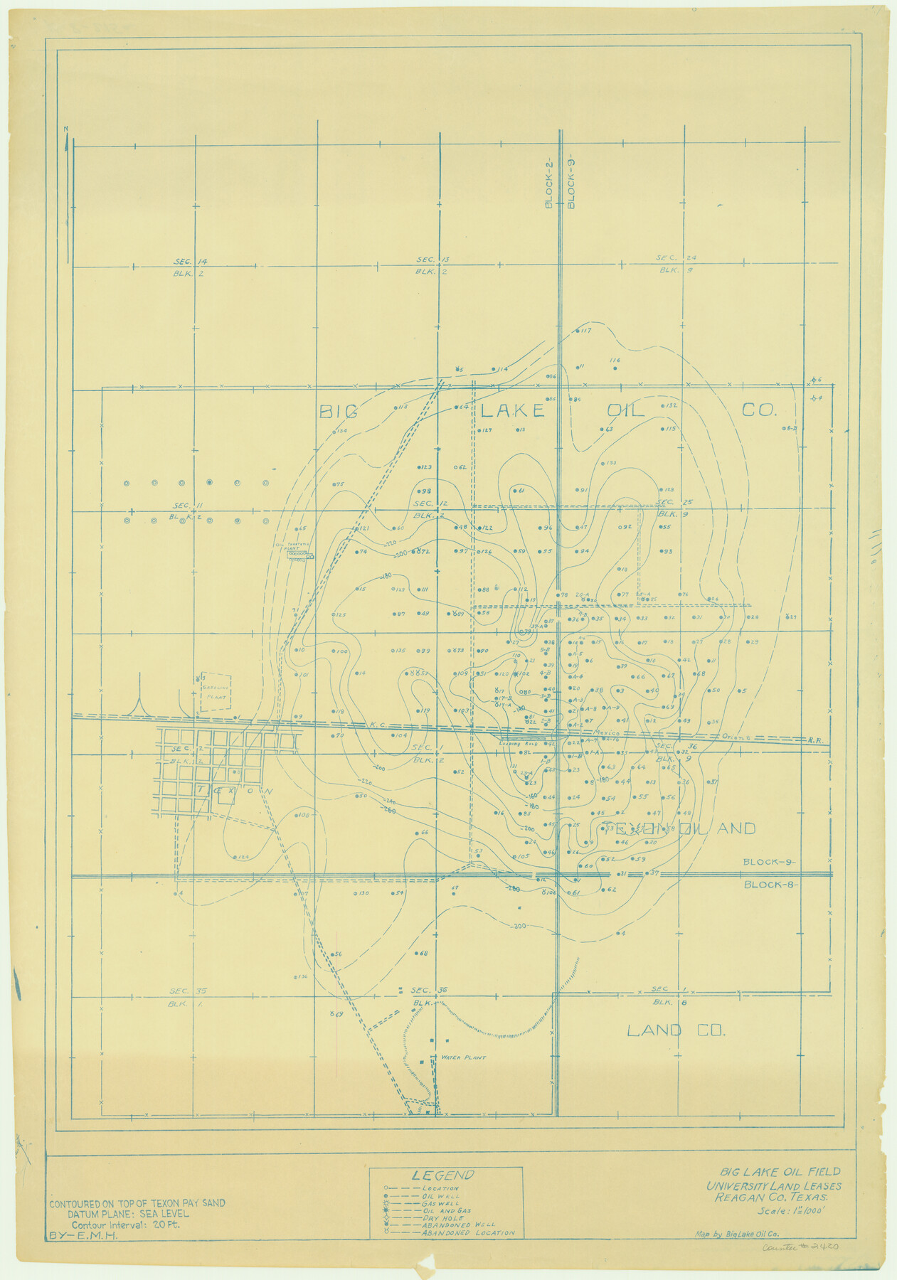
Big Lake Oil Field
K-8-215a
-
Map/Doc
2420
-
Collection
General Map Collection
-
Object Dates
1924 (Creation Date)
-
People and Organizations
Big Lake Oil Company (Author)
-
Height x Width
27.3 x 19.1 inches
69.3 x 48.5 cm
Part of: General Map Collection
Jim Hogg County Working Sketch 1

Print $20.00
- Digital $50.00
Jim Hogg County Working Sketch 1
1933
Size 30.4 x 25.3 inches
Map/Doc 66587
Map of Polk County

Print $20.00
- Digital $50.00
Map of Polk County
1879
Size 27.1 x 20.8 inches
Map/Doc 3959
El Paso County Rolled Sketch 61

Print $20.00
- Digital $50.00
El Paso County Rolled Sketch 61
1994
Size 27.8 x 39.0 inches
Map/Doc 5853
McMullen County Working Sketch 58

Print $40.00
- Digital $50.00
McMullen County Working Sketch 58
1984
Size 61.2 x 40.0 inches
Map/Doc 70759
Map of The Surveyed Part of Peters Colony Texas

Print $40.00
- Digital $50.00
Map of The Surveyed Part of Peters Colony Texas
1858
Size 45.6 x 58.5 inches
Map/Doc 1982
Flight Mission No. CUG-3P, Frame 91, Kleberg County

Print $20.00
- Digital $50.00
Flight Mission No. CUG-3P, Frame 91, Kleberg County
1956
Size 18.4 x 22.2 inches
Map/Doc 86261
Dimmit County Rolled Sketch 8

Print $20.00
- Digital $50.00
Dimmit County Rolled Sketch 8
1941
Size 30.0 x 29.6 inches
Map/Doc 5718
Flight Mission No. DQO-7K, Frame 78, Galveston County

Print $20.00
- Digital $50.00
Flight Mission No. DQO-7K, Frame 78, Galveston County
1952
Size 18.8 x 22.4 inches
Map/Doc 85105
Cass County Working Sketch 41

Print $20.00
- Digital $50.00
Cass County Working Sketch 41
1985
Size 34.0 x 42.7 inches
Map/Doc 67944
Maps & Lists Showing Prison Lands (Oil & Gas) Leased as of June 1955

Digital $50.00
Maps & Lists Showing Prison Lands (Oil & Gas) Leased as of June 1955
Size 11.1 x 8.8 inches
Map/Doc 62873
Tarrant County

Print $20.00
- Digital $50.00
Tarrant County
1942
Size 46.5 x 37.1 inches
Map/Doc 77431
Shelby County Working Sketch Graphic Index

Print $20.00
- Digital $50.00
Shelby County Working Sketch Graphic Index
1945
Size 42.9 x 44.3 inches
Map/Doc 76697
You may also like
The Republic County of Lamar. December 26, 1842

Print $20.00
The Republic County of Lamar. December 26, 1842
2020
Size 16.4 x 21.7 inches
Map/Doc 96205
Flight Mission No. CGI-3N, Frame 135, Cameron County

Print $20.00
- Digital $50.00
Flight Mission No. CGI-3N, Frame 135, Cameron County
1954
Size 18.7 x 22.1 inches
Map/Doc 84608
Webb County Sketch File 5-1

Print $4.00
- Digital $50.00
Webb County Sketch File 5-1
Size 3.7 x 12.6 inches
Map/Doc 39733
Hardeman County Sketch File 11

Print $42.00
- Digital $50.00
Hardeman County Sketch File 11
Size 9.2 x 9.1 inches
Map/Doc 25008

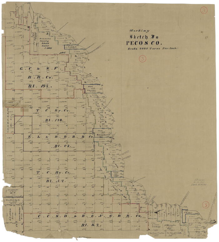
Pecos County Working Sketch 3
Print $20.00
- Digital $50.00
Pecos County Working Sketch 3
1927
Map/Doc 71473
English Field Notes of the Spanish Archives - Books SAS, DB4, GWS, JWB, and JWB3

English Field Notes of the Spanish Archives - Books SAS, DB4, GWS, JWB, and JWB3
1835
Map/Doc 96551
Duval County Sketch File 63

Print $4.00
- Digital $50.00
Duval County Sketch File 63
Size 14.5 x 8.9 inches
Map/Doc 21436
The Judicial District/County of Spring Creek. Created, January 21, 1841

Print $20.00
The Judicial District/County of Spring Creek. Created, January 21, 1841
2020
Size 15.7 x 21.7 inches
Map/Doc 96348
Flight Mission No. DCL-3C, Frame 105, Kenedy County

Print $20.00
- Digital $50.00
Flight Mission No. DCL-3C, Frame 105, Kenedy County
1943
Size 18.6 x 22.2 inches
Map/Doc 85800
Gaines County Sketch File 4

Print $4.00
- Digital $50.00
Gaines County Sketch File 4
1902
Size 14.3 x 8.5 inches
Map/Doc 23175
Dickens County Boundary File 5

Print $12.00
- Digital $50.00
Dickens County Boundary File 5
Size 10.8 x 8.2 inches
Map/Doc 52554