El Paso County Rolled Sketch 61
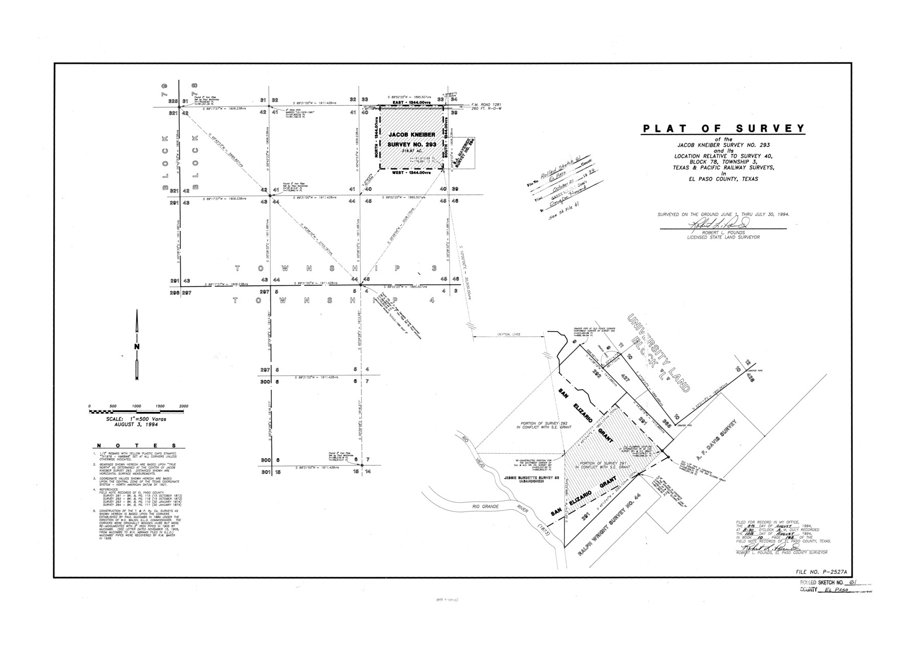
Plat of survey of the Jacob Kneiber survey no. 293 and its location relative to survey 40, Block 78, Township 3, Texas & Pacific Railway surveys in El Paso County, Texas
-
Map/Doc
5853
-
Collection
General Map Collection
-
Object Dates
1994/7/30 (Survey Date)
1994/10/21 (File Date)
1994/8/3 (Creation Date)
-
People and Organizations
Robert L. Pounds (Surveyor/Engineer)
-
Counties
El Paso
-
Subjects
Surveying Rolled Sketch
-
Height x Width
27.8 x 39.0 inches
70.6 x 99.1 cm
-
Medium
mylar, print
-
Scale
1" = 500 varas
-
Comments
See El Paso County Sketch File 41 (22238) for report and El Paso County Sketch File 31 (22084) for additional plats and correspondence.
Related maps
El Paso County Sketch File 31

Print $185.00
- Digital $50.00
El Paso County Sketch File 31
1968
Size 8.9 x 17.7 inches
Map/Doc 22084
El Paso County Sketch File 41

Print $6.00
- Digital $50.00
El Paso County Sketch File 41
1994
Size 11.4 x 8.8 inches
Map/Doc 22238
Part of: General Map Collection
Current Miscellaneous File 85

Print $10.00
- Digital $50.00
Current Miscellaneous File 85
Size 11.3 x 8.8 inches
Map/Doc 74235
Flight Mission No. CRC-4R, Frame 76, Chambers County

Print $20.00
- Digital $50.00
Flight Mission No. CRC-4R, Frame 76, Chambers County
1956
Size 18.8 x 22.4 inches
Map/Doc 84880
Presidio County Rolled Sketch 131A

Print $20.00
- Digital $50.00
Presidio County Rolled Sketch 131A
Size 25.5 x 26.3 inches
Map/Doc 10712
Newton County Rolled Sketch 16

Print $20.00
- Digital $50.00
Newton County Rolled Sketch 16
Size 30.5 x 21.9 inches
Map/Doc 6846
Wheeler County Sketch File 11

Print $47.00
- Digital $50.00
Wheeler County Sketch File 11
1992
Size 11.5 x 9.0 inches
Map/Doc 40014
Flight Mission No. DAG-21K, Frame 104, Matagorda County

Print $20.00
- Digital $50.00
Flight Mission No. DAG-21K, Frame 104, Matagorda County
1952
Size 18.7 x 22.3 inches
Map/Doc 86432
Kimble County Working Sketch 25

Print $20.00
- Digital $50.00
Kimble County Working Sketch 25
1937
Size 22.9 x 22.7 inches
Map/Doc 70093
Presidio County Working Sketch 52

Print $20.00
- Digital $50.00
Presidio County Working Sketch 52
1954
Size 46.5 x 27.6 inches
Map/Doc 71729
Flight Mission No. BRA-7M, Frame 131, Jefferson County

Print $20.00
- Digital $50.00
Flight Mission No. BRA-7M, Frame 131, Jefferson County
1953
Size 16.2 x 16.0 inches
Map/Doc 85525
Liberty County Working Sketch 45

Print $20.00
- Digital $50.00
Liberty County Working Sketch 45
1953
Size 28.9 x 39.8 inches
Map/Doc 70504

Flight Mission No. DAG-17K, Frame 125, Matagorda County

Print $20.00
- Digital $50.00
Flight Mission No. DAG-17K, Frame 125, Matagorda County
1952
Size 18.6 x 22.4 inches
Map/Doc 86345
You may also like
Duval County Sketch File 35

Print $24.00
- Digital $50.00
Duval County Sketch File 35
Size 14.4 x 8.8 inches
Map/Doc 21359
Map of Ferguson State Farm, Madison County, Texas

Print $20.00
- Digital $50.00
Map of Ferguson State Farm, Madison County, Texas
Size 21.6 x 26.1 inches
Map/Doc 62989
Nueces County Sketch File 12A

Print $20.00
- Digital $50.00
Nueces County Sketch File 12A
1889
Size 28.1 x 23.0 inches
Map/Doc 42177
Nueces River, Corpus Christi Sheet No. 3

Print $6.00
- Digital $50.00
Nueces River, Corpus Christi Sheet No. 3
1938
Size 31.7 x 25.9 inches
Map/Doc 65091
[School Leagues in Bailey and Lamb County]
![90987, [School Leagues in Bailey and Lamb County], Twichell Survey Records](https://historictexasmaps.com/wmedia_w700/maps/90987-2.tif.jpg)
Print $20.00
- Digital $50.00
[School Leagues in Bailey and Lamb County]
Size 30.5 x 25.2 inches
Map/Doc 90987
Greater Austin, Texas Streetmap

Greater Austin, Texas Streetmap
Size 45.8 x 36.2 inches
Map/Doc 94431
Right of Way and Track Map, the Missouri, Kansas and Texas Ry. of Texas operated by the Missouri, Kansas and Texas Ry. of Texas, San Antonio Division

Print $40.00
- Digital $50.00
Right of Way and Track Map, the Missouri, Kansas and Texas Ry. of Texas operated by the Missouri, Kansas and Texas Ry. of Texas, San Antonio Division
1918
Size 25.2 x 58.8 inches
Map/Doc 64584
Lipscomb County Boundary File 2

Print $6.00
- Digital $50.00
Lipscomb County Boundary File 2
Size 11.1 x 8.6 inches
Map/Doc 56315
San Jacinto County Working Sketch 3

Print $20.00
- Digital $50.00
San Jacinto County Working Sketch 3
1926
Size 16.7 x 19.7 inches
Map/Doc 63716
Sterling County Sketch File 6

Print $12.00
- Digital $50.00
Sterling County Sketch File 6
1912
Size 5.7 x 8.8 inches
Map/Doc 37115
Anderson County Working Sketch 18

Print $20.00
- Digital $50.00
Anderson County Working Sketch 18
1950
Size 19.9 x 21.2 inches
Map/Doc 67018
Flight Mission No. CUG-3P, Frame 81, Kleberg County

Print $20.00
- Digital $50.00
Flight Mission No. CUG-3P, Frame 81, Kleberg County
1956
Size 18.3 x 22.1 inches
Map/Doc 86256