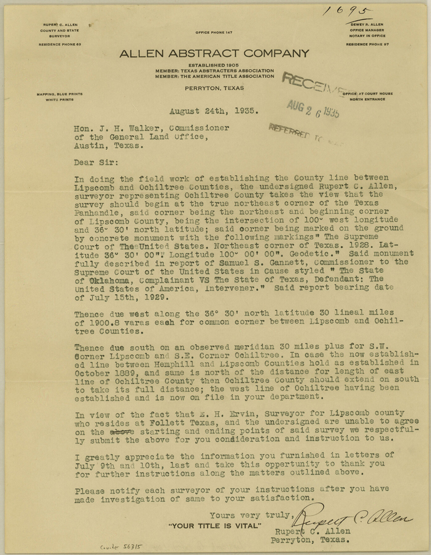
Lipscomb County Boundary File 2
Lipscomb-Ochiltree Co. Letter from Rupert C. Allen, Co. Sur. Ochiltree County
-
Map/Doc
56315
-
Collection
General Map Collection
-
Counties
Lipscomb
-
Subjects
County Boundaries
-
Height x Width
11.1 x 8.6 inches
28.2 x 21.8 cm
Part of: General Map Collection
Nueces County Aerial Photograph Index Sheet 2

Print $20.00
- Digital $50.00
Nueces County Aerial Photograph Index Sheet 2
1956
Size 19.5 x 23.3 inches
Map/Doc 83737
Gonzales County Boundary File 1b

Print $52.00
- Digital $50.00
Gonzales County Boundary File 1b
Size 8.0 x 5.0 inches
Map/Doc 53803
Lipscomb County Working Sketch 1

Print $20.00
- Digital $50.00
Lipscomb County Working Sketch 1
1964
Size 30.7 x 34.1 inches
Map/Doc 70577
Flight Mission No. CRC-4R, Frame 97, Chambers County

Print $20.00
- Digital $50.00
Flight Mission No. CRC-4R, Frame 97, Chambers County
1956
Size 18.6 x 22.2 inches
Map/Doc 84894
Presidio County Working Sketch 78

Print $20.00
- Digital $50.00
Presidio County Working Sketch 78
1965
Size 24.8 x 25.1 inches
Map/Doc 71755
Val Verde County Sketch File Z14

Print $20.00
- Digital $50.00
Val Verde County Sketch File Z14
1899
Size 22.1 x 20.6 inches
Map/Doc 12556
Wilbarger County Sketch File 7

Print $4.00
- Digital $50.00
Wilbarger County Sketch File 7
1883
Size 12.7 x 8.3 inches
Map/Doc 40175
Crockett County Working Sketch 72

Print $20.00
- Digital $50.00
Crockett County Working Sketch 72
1963
Size 43.9 x 38.5 inches
Map/Doc 68405
Presidio County Rolled Sketch 56

Print $20.00
- Digital $50.00
Presidio County Rolled Sketch 56
1915
Size 21.8 x 17.1 inches
Map/Doc 7349
Map of the Southern Pacific Rail Road through Harrison County, Texas

Print $40.00
- Digital $50.00
Map of the Southern Pacific Rail Road through Harrison County, Texas
1860
Size 26.8 x 76.6 inches
Map/Doc 64140
United States - Gulf Coast - Galveston to Rio Grande

Print $20.00
- Digital $50.00
United States - Gulf Coast - Galveston to Rio Grande
1919
Size 26.5 x 18.2 inches
Map/Doc 72747
Flight Mission No. CGI-3N, Frame 186, Cameron County

Print $20.00
- Digital $50.00
Flight Mission No. CGI-3N, Frame 186, Cameron County
1954
Size 18.6 x 22.3 inches
Map/Doc 84650
You may also like
Jefferson County Rolled Sketch 35

Print $20.00
- Digital $50.00
Jefferson County Rolled Sketch 35
1957
Size 37.9 x 26.0 inches
Map/Doc 6394
Liberty County Sketch File 50

Print $42.00
- Digital $50.00
Liberty County Sketch File 50
1879
Size 12.6 x 8.4 inches
Map/Doc 30014
Zavala County Working Sketch 30

Print $20.00
- Digital $50.00
Zavala County Working Sketch 30
1989
Size 36.8 x 28.1 inches
Map/Doc 62105
Flight Mission No. DAH-9M, Frame 85, Orange County

Print $20.00
- Digital $50.00
Flight Mission No. DAH-9M, Frame 85, Orange County
1953
Size 18.5 x 22.7 inches
Map/Doc 86849
[Map showing J. H. Gibson Blocks D and DD]
![92006, [Map showing J. H. Gibson Blocks D and DD], Twichell Survey Records](https://historictexasmaps.com/wmedia_w700/maps/92006-1.tif.jpg)
Print $20.00
- Digital $50.00
[Map showing J. H. Gibson Blocks D and DD]
Size 31.5 x 22.0 inches
Map/Doc 92006
Concho County Rolled Sketch 20

Print $20.00
- Digital $50.00
Concho County Rolled Sketch 20
1968
Size 26.2 x 38.8 inches
Map/Doc 5554
Flight Mission No. DQN-6K, Frame 74, Calhoun County

Print $20.00
- Digital $50.00
Flight Mission No. DQN-6K, Frame 74, Calhoun County
1953
Size 18.5 x 22.2 inches
Map/Doc 84446
Hutchinson County Sketch File 38

Print $40.00
- Digital $50.00
Hutchinson County Sketch File 38
1935
Size 17.6 x 14.2 inches
Map/Doc 27280
Subdivision of the C.C. Slaughter Block No. 1, League 101 & part of League 102, Jeff Davis Co. School Land, part of League 100, Brewster Co. School Land and League 118 & part of Leagues 117 & 119, Knox Co. School Land

Print $20.00
- Digital $50.00
Subdivision of the C.C. Slaughter Block No. 1, League 101 & part of League 102, Jeff Davis Co. School Land, part of League 100, Brewster Co. School Land and League 118 & part of Leagues 117 & 119, Knox Co. School Land
1926
Size 18.8 x 19.4 inches
Map/Doc 90459
Bailey County Working Sketch 6

Print $20.00
- Digital $50.00
Bailey County Working Sketch 6
1966
Size 37.0 x 34.5 inches
Map/Doc 67593
Trinity County Sketch File 35a

Print $6.00
- Digital $50.00
Trinity County Sketch File 35a
1921
Size 16.8 x 8.8 inches
Map/Doc 38587
Falls County Sketch File 19

Print $4.00
- Digital $50.00
Falls County Sketch File 19
1871
Size 12.8 x 8.4 inches
Map/Doc 22386