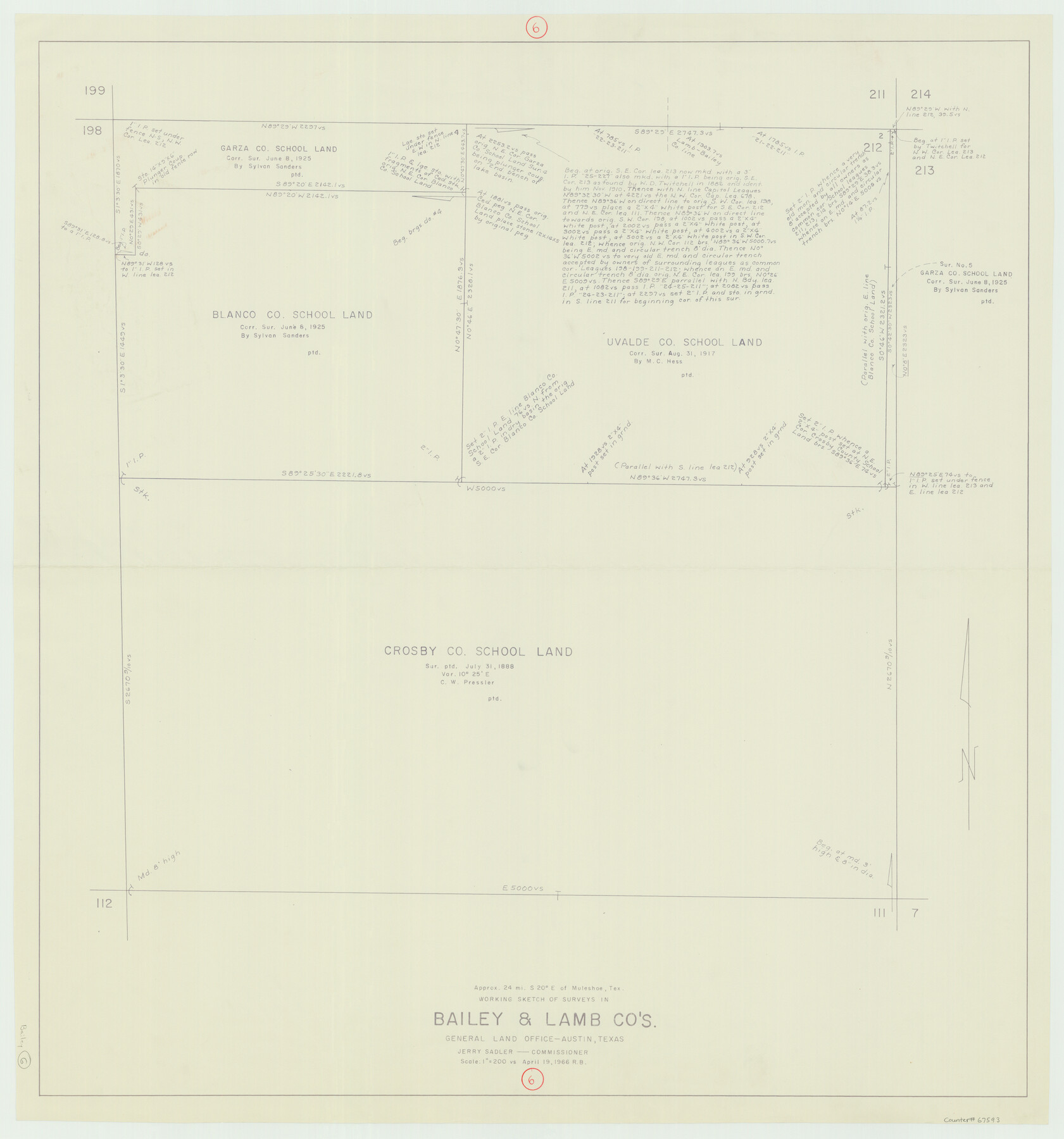
Bailey County Working Sketch 6
-
Map/Doc
67593
-
Collection
General Map Collection
-
Object Dates
4/19/1966 (Creation Date)
-
People and Organizations
Roy Buckholts (Draftsman)
Jerry Sadler (GLO Commissioner)
-
Counties
Bailey Lamb
-
Subjects
Surveying Working Sketch
-
Height x Width
37.0 x 34.5 inches
94.0 x 87.6 cm
-
Scale
1" = 200 varas
-
Comments
Surveys located about 24 miles South 20 degrees East of Muleshoe, Texas.
Part of: General Map Collection
Medina County Working Sketch 16

Print $20.00
- Digital $50.00
Medina County Working Sketch 16
1979
Size 27.1 x 28.2 inches
Map/Doc 70931
Map of Gregg County

Print $20.00
- Digital $50.00
Map of Gregg County
1874
Size 14.0 x 13.9 inches
Map/Doc 3604
[Surveys along the Little River]
![76048, [Surveys along the Little River], General Map Collection](https://historictexasmaps.com/wmedia_w700/maps/76048.tif.jpg)
Print $2.00
- Digital $50.00
[Surveys along the Little River]
1846
Size 10.6 x 7.8 inches
Map/Doc 76048
Deaf Smith County Sketch File 7

Print $4.00
- Digital $50.00
Deaf Smith County Sketch File 7
1917
Size 11.3 x 9.0 inches
Map/Doc 20664
Hudspeth County Rolled Sketch 63

Print $20.00
- Digital $50.00
Hudspeth County Rolled Sketch 63
Size 41.8 x 47.9 inches
Map/Doc 9227
Wichita County Working Sketch 13

Print $20.00
- Digital $50.00
Wichita County Working Sketch 13
1921
Size 16.5 x 32.8 inches
Map/Doc 72523
Histoire de la Louisiane et de la Cession de Cette Colonie par la France aux États-Unis de l'Amérique Septentrionale

Histoire de la Louisiane et de la Cession de Cette Colonie par la France aux États-Unis de l'Amérique Septentrionale
1829
Map/Doc 97259
Denton County Working Sketch 36

Print $20.00
- Digital $50.00
Denton County Working Sketch 36
2008
Size 18.5 x 29.0 inches
Map/Doc 88877
Robertson County Working Sketch 10

Print $20.00
- Digital $50.00
Robertson County Working Sketch 10
1984
Size 20.1 x 21.6 inches
Map/Doc 63583
Garza County Sketch File 4a

Print $4.00
- Digital $50.00
Garza County Sketch File 4a
1883
Size 14.2 x 8.8 inches
Map/Doc 24048
Real County Working Sketch 9

Print $20.00
- Digital $50.00
Real County Working Sketch 9
1929
Size 18.4 x 19.5 inches
Map/Doc 71901
Louisiana and Texas Intracoastal Waterway - Matagorda Bay to San Antonio Bay Dredging - Sheet 1

Print $20.00
- Digital $50.00
Louisiana and Texas Intracoastal Waterway - Matagorda Bay to San Antonio Bay Dredging - Sheet 1
1942
Size 31.2 x 41.2 inches
Map/Doc 61823
You may also like
Flight Mission No. BRA-7M, Frame 36, Jefferson County

Print $20.00
- Digital $50.00
Flight Mission No. BRA-7M, Frame 36, Jefferson County
1953
Size 18.7 x 22.3 inches
Map/Doc 85487

Real County Working Sketch 29

Print $40.00
- Digital $50.00
Real County Working Sketch 29
1947
Size 58.2 x 40.5 inches
Map/Doc 71921

The Chief Justice County of Victoria. September 20, 1837

Print $20.00
The Chief Justice County of Victoria. September 20, 1837
2020
Size 23.3 x 21.7 inches
Map/Doc 96075
Cameron County Rolled Sketch Z6

Print $20.00
- Digital $50.00
Cameron County Rolled Sketch Z6
1937
Size 28.3 x 33.8 inches
Map/Doc 5404
Map of Glasscock County, Texas

Print $20.00
Map of Glasscock County, Texas
Size 22.7 x 18.3 inches
Map/Doc 88943
Montague County Rolled Sketch 3

Print $20.00
- Digital $50.00
Montague County Rolled Sketch 3
1940
Size 24.0 x 15.9 inches
Map/Doc 6787
Brewster County Rolled Sketch 103

Print $40.00
- Digital $50.00
Brewster County Rolled Sketch 103
1955
Size 51.8 x 27.9 inches
Map/Doc 5256
Colorado County Working Sketch 19

Print $20.00
- Digital $50.00
Colorado County Working Sketch 19
1958
Size 25.3 x 19.1 inches
Map/Doc 68119
Bowie County Sketch File 9

Print $10.00
- Digital $50.00
Bowie County Sketch File 9
Size 8.1 x 3.9 inches
Map/Doc 14907
