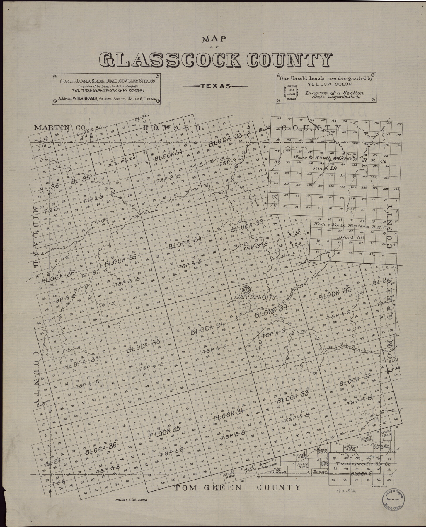
Map of Glasscock County, Texas
-
Map/Doc
88943
-
Collection
Library of Congress
-
People and Organizations
C. J. Canda, S. J. Drake, and W. Strauss (Publisher)
Dallas Lithograph Company (Printer)
M. Stakemann (Draftsman)
-
Counties
Glasscock
-
Subjects
County
-
Height x Width
22.7 x 18.3 inches
57.7 x 46.5 cm
-
Comments
Prints available from the GLO courtesy of Library of Congress, Geography and Map Division.
Part of: Library of Congress
[Map showing T&P Lands in El Paso County]
![88934, [Map showing T&P Lands in El Paso County], Library of Congress](https://historictexasmaps.com/wmedia_w700/maps/88934.tif.jpg)
Print $20.00
[Map showing T&P Lands in El Paso County]
Size 17.3 x 22.2 inches
Map/Doc 88934
Mapa que comprende la Frontera de los Dominios del Rey, en la America Septentrional, segun el original que hizo D. Joseph de Urrutia, sobre varios puntos observados por él, y el Capitan de Yngenieros D. Nicolas Lafora

Print $40.00
Mapa que comprende la Frontera de los Dominios del Rey, en la America Septentrional, segun el original que hizo D. Joseph de Urrutia, sobre varios puntos observados por él, y el Capitan de Yngenieros D. Nicolas Lafora
1769
Size 50.9 x 128.2 inches
Map/Doc 95711
City and Harbor of Port Arthur Texas, Bird's Eye View Looking South to the Gulf of Mexico

Print $20.00
City and Harbor of Port Arthur Texas, Bird's Eye View Looking South to the Gulf of Mexico
1912
Size 17.4 x 39.9 inches
Map/Doc 93483
Map of the southern states, including rail roads, county towns, state capitals, count roads, the southern coast from Delaware to Texas, showing the harbors, inlets, forts and position of blockading ships.

Print $20.00
Map of the southern states, including rail roads, county towns, state capitals, count roads, the southern coast from Delaware to Texas, showing the harbors, inlets, forts and position of blockading ships.
1863
Size 20.1 x 29.9 inches
Map/Doc 93571
[Map showing T&P Lands in El Paso County]
![88932, [Map showing T&P Lands in El Paso County], Library of Congress](https://historictexasmaps.com/wmedia_w700/maps/88932.tif.jpg)
Print $20.00
[Map showing T&P Lands in El Paso County]
Size 22.2 x 17.1 inches
Map/Doc 88932
J. H. Colton's map of the state of Louisiana and eastern part of Texas compiled from United States Surveys, and other authentic sources, showing the counties, townships, sections. Fractional sections, settlement rights, railroads, &c.

Print $20.00
J. H. Colton's map of the state of Louisiana and eastern part of Texas compiled from United States Surveys, and other authentic sources, showing the counties, townships, sections. Fractional sections, settlement rights, railroads, &c.
1863
Size 35.8 x 43.3 inches
Map/Doc 93603
![88994, San Saba Co[unty], Library of Congress](https://historictexasmaps.com/wmedia_w700/maps/88994-1.tif.jpg)

Map showing railroads and connecting lines of the Northern Texas Traction Co. from Ft. Worth to Dallas, Texas

Print $20.00
Map showing railroads and connecting lines of the Northern Texas Traction Co. from Ft. Worth to Dallas, Texas
1905
Size 3.5 x 7.5 inches
Map/Doc 93602
[Map showing T&P Lands in El Paso County]
![88933, [Map showing T&P Lands in El Paso County], Library of Congress](https://historictexasmaps.com/wmedia_w700/maps/88933.tif.jpg)
Print $20.00
[Map showing T&P Lands in El Paso County]
Size 17.2 x 22.1 inches
Map/Doc 88933
Nelson & White's Official Map of Beaumont

Print $40.00
Nelson & White's Official Map of Beaumont
1902
Size 54.3 x 39.4 inches
Map/Doc 93558
Map showing the distribution of the slave population of the southern states of the United States. Compiled from the census of 1860

Print $20.00
Map showing the distribution of the slave population of the southern states of the United States. Compiled from the census of 1860
1861
Size 27.8 x 34.8 inches
Map/Doc 95749
You may also like
Reeves County Rolled Sketch 28

Print $20.00
- Digital $50.00
Reeves County Rolled Sketch 28
1985
Size 28.1 x 40.1 inches
Map/Doc 7497
La Salle County Working Sketch 48

Print $20.00
- Digital $50.00
La Salle County Working Sketch 48
1983
Size 26.2 x 36.0 inches
Map/Doc 70349
Henderson County Working Sketch 7

Print $20.00
- Digital $50.00
Henderson County Working Sketch 7
1922
Size 12.5 x 18.8 inches
Map/Doc 66140
Val Verde County Working Sketch 81

Print $20.00
- Digital $50.00
Val Verde County Working Sketch 81
1973
Size 24.6 x 41.7 inches
Map/Doc 72216
Matagorda County Working Sketch 2

Print $20.00
- Digital $50.00
Matagorda County Working Sketch 2
Size 32.6 x 37.0 inches
Map/Doc 70860
Montague County Working Sketch Graphic Index

Print $20.00
- Digital $50.00
Montague County Working Sketch Graphic Index
1924
Size 45.3 x 33.2 inches
Map/Doc 76645
Culberson County Working Sketch 69
Print $40.00
- Digital $50.00
Culberson County Working Sketch 69
1975
Size 49.4 x 32.2 inches
Map/Doc 68523
Boundary and Ownership map, Laguna Atascosa National Wildlife Refuge, Cameron and Willacy Counties, Texas

Print $40.00
- Digital $50.00
Boundary and Ownership map, Laguna Atascosa National Wildlife Refuge, Cameron and Willacy Counties, Texas
Size 72.7 x 43.0 inches
Map/Doc 60396
Flight Mission No. DIX-5P, Frame 114, Aransas County

Print $20.00
- Digital $50.00
Flight Mission No. DIX-5P, Frame 114, Aransas County
1956
Size 17.4 x 17.6 inches
Map/Doc 83793
Sunset, Montague Co., Texas

Print $20.00
Sunset, Montague Co., Texas
1890
Size 9.7 x 14.5 inches
Map/Doc 89209
Texas, Corpus Christi, Corpus Christi to Laguna Madre

Print $40.00
- Digital $50.00
Texas, Corpus Christi, Corpus Christi to Laguna Madre
1934
Size 35.1 x 48.6 inches
Map/Doc 73457
General Highway Map, Concho County, Texas

Print $20.00
General Highway Map, Concho County, Texas
1961
Size 24.6 x 18.3 inches
Map/Doc 79420