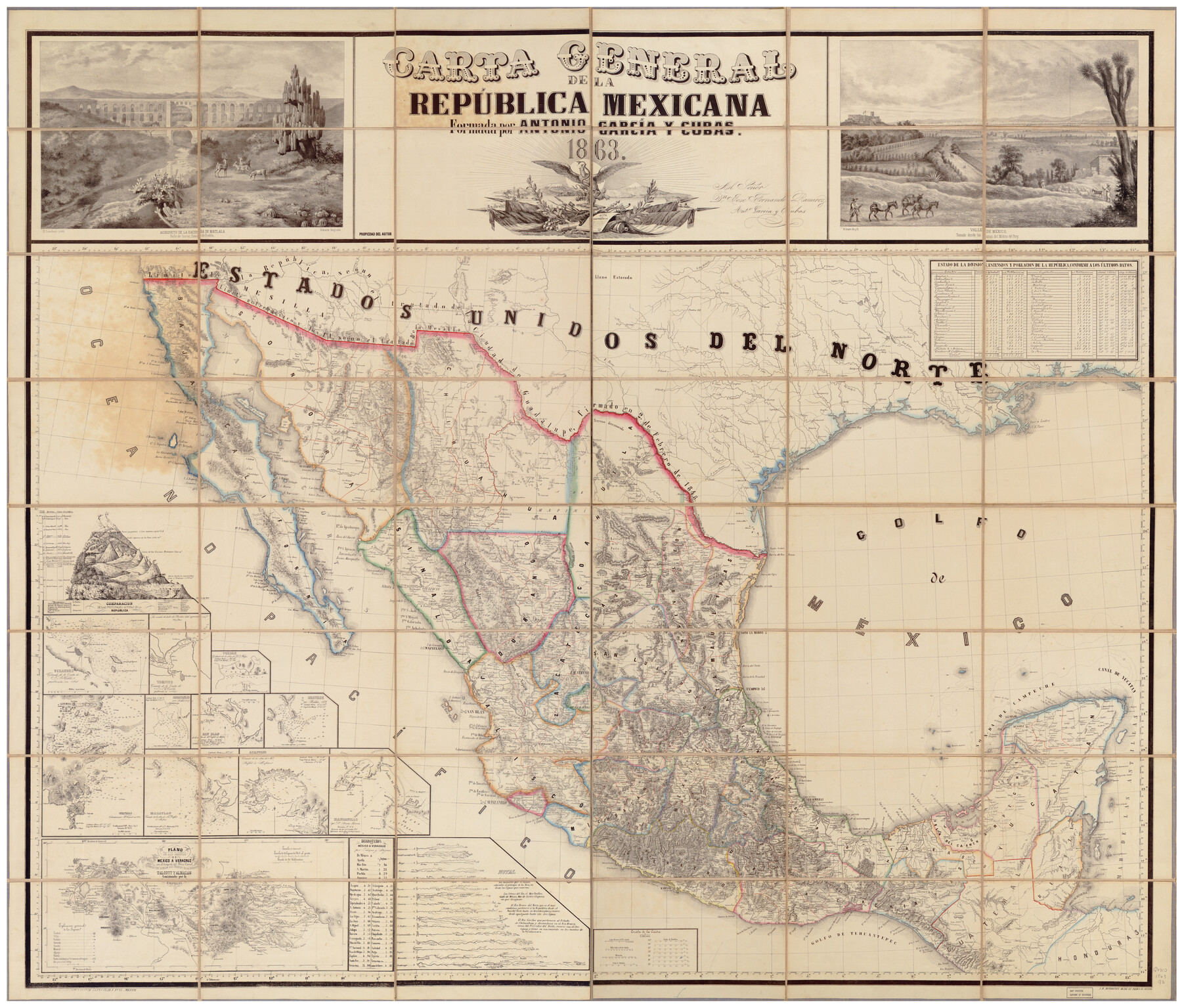
Carta General de la República Mexicana formada por Antonio García y Cubas
-
Map/Doc
95307
-
Collection
Library of Congress
-
Object Dates
1863 (Creation Date)
-
People and Organizations
Antonio Garcia Cubas (Cartographer)
-
Subjects
Mexico
-
Height x Width
48.7 x 57.1 inches
123.7 x 145.0 cm
-
Medium
digital image
-
Scale
1:1,000,000
-
Comments
For more information see here. Prints available from the GLO courtesy of Library of Congress, Geography and Map Division.
Part of: Library of Congress
Colton's new map of the state of Texas, the Indian Territory and adjoining portions of New Mexico, Louisiana, and Arkansas

Print $20.00
Colton's new map of the state of Texas, the Indian Territory and adjoining portions of New Mexico, Louisiana, and Arkansas
1872
Size 31.1 x 36.6 inches
Map/Doc 93579

Map of San Saba County : exhibiting the extent of public surveys, land grants, and other official information…

Print $20.00
Map of San Saba County : exhibiting the extent of public surveys, land grants, and other official information…
1876
Size 22.8 x 20.1 inches
Map/Doc 93593
Map of South Pacific Rail Road Co. of Missouri.

Print $20.00
Map of South Pacific Rail Road Co. of Missouri.
1870
Size 13.4 x 15.7 inches
Map/Doc 93613

Preliminary Chart of the Northwestern Part of the Gulf of Mexico - Unfinished Proof

Print $40.00
Preliminary Chart of the Northwestern Part of the Gulf of Mexico - Unfinished Proof
1861
Size 31.5 x 68.9 inches
Map/Doc 95308
![88957, Hutchinson Co[unty], Library of Congress](https://historictexasmaps.com/wmedia_w700/maps/88957.tif.jpg)

City of Houston and Environs

Print $20.00
City of Houston and Environs
1895
Size 30.4 x 33.6 inches
Map/Doc 93486
Corpus Christi and Rio Grande Railway Company, [map showing the proposed railroad between Laredo and Corpus Christi and its connections with Mexico]
![93580, Corpus Christi and Rio Grande Railway Company, [map showing the proposed railroad between Laredo and Corpus Christi and its connections with Mexico], Library of Congress](https://historictexasmaps.com/wmedia_w700/maps/93580.tif.jpg)
Print $20.00
Corpus Christi and Rio Grande Railway Company, [map showing the proposed railroad between Laredo and Corpus Christi and its connections with Mexico]
1874
Size 14.6 x 24.0 inches
Map/Doc 93580

J. H. Colton's map of the state of Louisiana and eastern part of Texas compiled from United States Surveys, and other authentic sources, showing the counties, townships, sections. Fractional sections, settlement rights, railroads, &c.

Print $20.00
J. H. Colton's map of the state of Louisiana and eastern part of Texas compiled from United States Surveys, and other authentic sources, showing the counties, townships, sections. Fractional sections, settlement rights, railroads, &c.
1863
Size 35.8 x 43.3 inches
Map/Doc 93603
You may also like
Brewster County Sketch File N-30

Print $6.00
- Digital $50.00
Brewster County Sketch File N-30
1969
Size 11.2 x 8.9 inches
Map/Doc 15708
Titus County Sketch File 10

Print $4.00
- Digital $50.00
Titus County Sketch File 10
1871
Size 8.1 x 12.9 inches
Map/Doc 38148
Moore County Working Sketch Graphic Index

Print $20.00
- Digital $50.00
Moore County Working Sketch Graphic Index
1932
Size 41.3 x 39.0 inches
Map/Doc 76648
Mills County Sketch File 14

Print $4.00
- Digital $50.00
Mills County Sketch File 14
1871
Size 6.8 x 8.0 inches
Map/Doc 31661
Motley County Sketch File 20 (N)

Print $6.00
- Digital $50.00
Motley County Sketch File 20 (N)
1943
Size 11.3 x 8.8 inches
Map/Doc 32066
Trinity River, Allison Sheet/Denton Creek

Print $4.00
- Digital $50.00
Trinity River, Allison Sheet/Denton Creek
1928
Size 26.3 x 24.2 inches
Map/Doc 65223
Louisiana and Texas Intracoastal Waterway Proposed Extension to Rio Grande Valley

Print $20.00
- Digital $50.00
Louisiana and Texas Intracoastal Waterway Proposed Extension to Rio Grande Valley
1941
Size 22.0 x 33.0 inches
Map/Doc 61889
Johnson County Sketch File 1

Print $48.00
- Digital $50.00
Johnson County Sketch File 1
Size 8.0 x 6.9 inches
Map/Doc 28427
Block 11, Capitol Syndicate Subdivision of Capitol Land Reservation Leagues

Print $20.00
- Digital $50.00
Block 11, Capitol Syndicate Subdivision of Capitol Land Reservation Leagues
Size 25.0 x 26.2 inches
Map/Doc 90737
[North part of Block 8, H. & G. N. RR. Co.]
![90376, [North part of Block 8, H. & G. N. RR. Co.], Twichell Survey Records](https://historictexasmaps.com/wmedia_w700/maps/90376-1.tif.jpg)
Print $2.00
- Digital $50.00
[North part of Block 8, H. & G. N. RR. Co.]
Size 6.6 x 8.9 inches
Map/Doc 90376
Armstrong County Working Sketch 4

Print $20.00
- Digital $50.00
Armstrong County Working Sketch 4
1918
Size 23.9 x 32.0 inches
Map/Doc 67235
Calcasieu Pass to Sabine Pass

Print $20.00
- Digital $50.00
Calcasieu Pass to Sabine Pass
1943
Size 44.5 x 35.1 inches
Map/Doc 69805