Presidio County Rolled Sketch 137
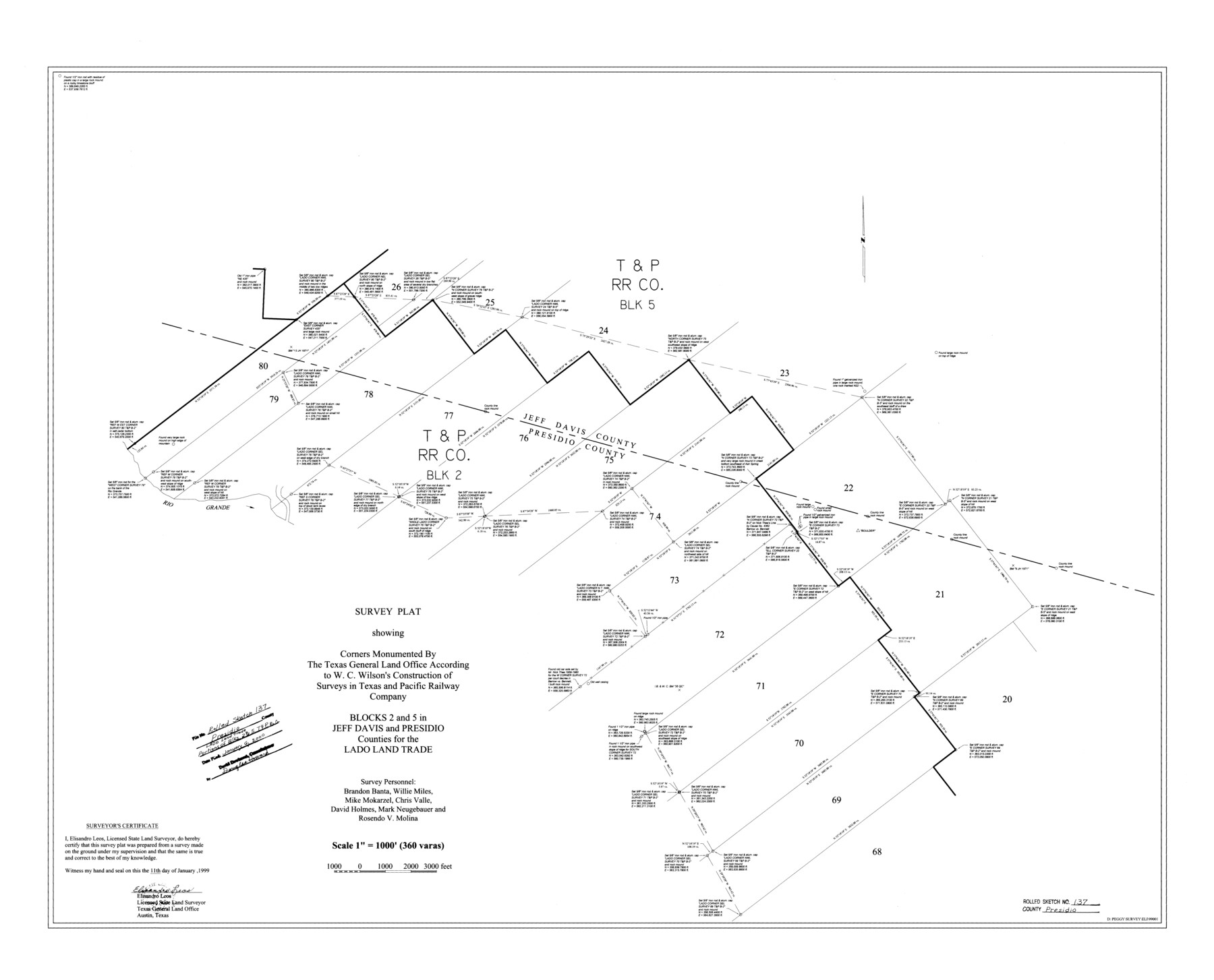
Survey plat showing corners monumented by the Texas General Land Office according to W.C. Wilson's construction of surveys in Texas and Pacific Railway Company Blocks 2 and 5 in Jeff Davis and Presidio Counties for the Lado Land Trade
-
Map/Doc
8352
-
Collection
General Map Collection
-
Object Dates
1999/1/11 (Creation Date)
2000/1/6 (File Date)
-
People and Organizations
Elisandro Leos (Surveyor/Engineer)
Brandon Banta (Chainman/Field Personnel)
Willie Miles (Chainman/Field Personnel)
Mike Mokarzel (Chainman/Field Personnel)
Chris Valle (Chainman/Field Personnel)
David Holmes (Chainman/Field Personnel)
Mark Neugebauer (Chainman/Field Personnel)
Rosendo V. Molina (Chainman/Field Personnel)
-
Counties
Presidio Jeff Davis
-
Subjects
Surveying Rolled Sketch
-
Height x Width
38.7 x 47.9 inches
98.3 x 121.7 cm
-
Medium
mylar, print
-
Scale
1" = 360 varas
Part of: General Map Collection
Hudspeth County Working Sketch 54

Print $20.00
- Digital $50.00
Hudspeth County Working Sketch 54
1989
Size 18.8 x 36.2 inches
Map/Doc 66339
Galveston Co.

Print $40.00
- Digital $50.00
Galveston Co.
1891
Size 37.5 x 53.8 inches
Map/Doc 66833
Garza County Sketch File 8

Print $8.00
- Digital $50.00
Garza County Sketch File 8
1900
Size 10.3 x 8.2 inches
Map/Doc 24062
United States - Gulf Coast Texas - Northern part of Laguna Madre

Print $20.00
- Digital $50.00
United States - Gulf Coast Texas - Northern part of Laguna Madre
1941
Size 27.2 x 18.4 inches
Map/Doc 72935
Flight Mission No. DQN-1K, Frame 74, Calhoun County

Print $20.00
- Digital $50.00
Flight Mission No. DQN-1K, Frame 74, Calhoun County
1953
Size 18.4 x 22.1 inches
Map/Doc 84161
Flight Mission No. CGI-4N, Frame 185, Cameron County

Print $20.00
- Digital $50.00
Flight Mission No. CGI-4N, Frame 185, Cameron County
1955
Size 18.6 x 22.3 inches
Map/Doc 84688
Yoakum County

Print $20.00
- Digital $50.00
Yoakum County
1932
Size 45.7 x 34.1 inches
Map/Doc 73331
Map of Palo Pinto County Texas

Print $20.00
- Digital $50.00
Map of Palo Pinto County Texas
1879
Size 22.0 x 17.3 inches
Map/Doc 3933
Van Zandt County Sketch File 26

Print $4.00
- Digital $50.00
Van Zandt County Sketch File 26
1858
Size 6.7 x 7.9 inches
Map/Doc 39445
Carta Politica

Print $20.00
- Digital $50.00
Carta Politica
1897
Size 26.2 x 34.1 inches
Map/Doc 96797

Edwards County Sketch File 34

Print $20.00
- Digital $50.00
Edwards County Sketch File 34
Size 16.8 x 19.0 inches
Map/Doc 11434
You may also like
Brazos County Working Sketch 2

Print $20.00
- Digital $50.00
Brazos County Working Sketch 2
1950
Size 31.9 x 36.0 inches
Map/Doc 67477
The Chief Justice County of Harrisburg. January 30, 1837

Print $20.00
The Chief Justice County of Harrisburg. January 30, 1837
2020
Size 17.5 x 21.7 inches
Map/Doc 96049
Harris County Working Sketch 71

Print $20.00
- Digital $50.00
Harris County Working Sketch 71
1957
Size 26.8 x 42.3 inches
Map/Doc 65963
Hunt County Boundary File 7

Print $14.00
- Digital $50.00
Hunt County Boundary File 7
Size 14.1 x 8.7 inches
Map/Doc 55228
Jackson County Boundary File 3

Print $10.00
- Digital $50.00
Jackson County Boundary File 3
Size 10.9 x 8.7 inches
Map/Doc 55455
Map of DeWitt County

Print $20.00
- Digital $50.00
Map of DeWitt County
1853
Size 21.5 x 25.5 inches
Map/Doc 3479
Coleman County Sketch File 45

Print $20.00
- Digital $50.00
Coleman County Sketch File 45
1897
Size 23.9 x 23.8 inches
Map/Doc 11124
Kerr County Sketch File 23

Print $8.00
- Digital $50.00
Kerr County Sketch File 23
1959
Size 14.2 x 8.8 inches
Map/Doc 28901
El Paso County Boundary File 4a

Print $44.00
- Digital $50.00
El Paso County Boundary File 4a
Size 14.1 x 8.6 inches
Map/Doc 53044
Chambers County Boundary File 1

Print $28.00
- Digital $50.00
Chambers County Boundary File 1
Size 8.9 x 6.7 inches
Map/Doc 51226
Hardin County Sketch File 46

Print $8.00
- Digital $50.00
Hardin County Sketch File 46
1875
Size 12.8 x 8.4 inches
Map/Doc 25196
Colorado County Working Sketch 31

Print $20.00
- Digital $50.00
Colorado County Working Sketch 31
1981
Size 9.9 x 19.5 inches
Map/Doc 68131