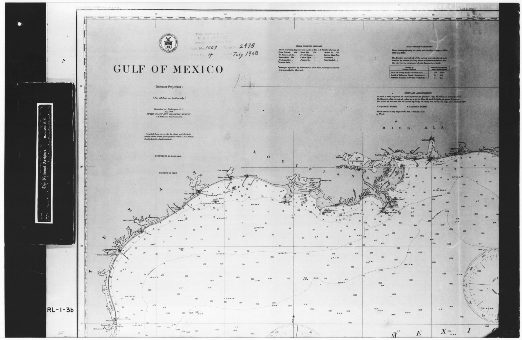
Gulf of Mexico
RL-1-3b
-
Map/Doc
72659
-
Collection
General Map Collection
-
Object Dates
1908 (Creation Date)
-
People and Organizations
Coast and Geodetic Survey (Publisher)
Coast and Geodetic Survey (Author)
Coast and Geodetic Survey (Compiler)
-
Subjects
Gulf of Mexico Nautical Charts
-
Height x Width
18.2 x 27.9 inches
46.2 x 70.9 cm
-
Comments
B/W photostat copy from National Archives in multiple pieces. Chart No. 1007, Edition 4, July 1908, Mercator Projection
Part of: General Map Collection
Pecos County Working Sketch 68

Print $20.00
- Digital $50.00
Pecos County Working Sketch 68
1955
Size 41.4 x 24.0 inches
Map/Doc 71540
Hudspeth County Rolled Sketch 45

Print $20.00
- Digital $50.00
Hudspeth County Rolled Sketch 45
1958
Size 20.5 x 35.6 inches
Map/Doc 6254
South Part of El Paso Co.

Print $20.00
- Digital $50.00
South Part of El Paso Co.
1977
Size 36.5 x 47.8 inches
Map/Doc 95491
Wood County Boundary File 6

Print $32.00
- Digital $50.00
Wood County Boundary File 6
Size 14.3 x 8.6 inches
Map/Doc 60180
Outer Continental Shelf Leasing Maps (Louisiana Offshore Operations)

Print $20.00
- Digital $50.00
Outer Continental Shelf Leasing Maps (Louisiana Offshore Operations)
1954
Size 16.2 x 16.3 inches
Map/Doc 76107
Chambers County Working Sketch 14

Print $20.00
- Digital $50.00
Chambers County Working Sketch 14
1957
Size 30.3 x 19.0 inches
Map/Doc 67997
Bee County Sketch File 4a

Print $4.00
- Digital $50.00
Bee County Sketch File 4a
Size 7.1 x 8.5 inches
Map/Doc 14270
Harris County Sketch File A

Print $4.00
- Digital $50.00
Harris County Sketch File A
1898
Size 12.8 x 8.5 inches
Map/Doc 25306
Dimmit County

Print $40.00
- Digital $50.00
Dimmit County
1976
Size 42.2 x 48.9 inches
Map/Doc 77265
Flight Mission No. DAG-21K, Frame 39, Matagorda County

Print $20.00
- Digital $50.00
Flight Mission No. DAG-21K, Frame 39, Matagorda County
1952
Size 18.6 x 22.3 inches
Map/Doc 86406
Flight Mission No. CRC-4R, Frame 172, Chambers County

Print $20.00
- Digital $50.00
Flight Mission No. CRC-4R, Frame 172, Chambers County
1956
Size 18.6 x 22.3 inches
Map/Doc 84923
Brewster County Rolled Sketch 137

Print $20.00
- Digital $50.00
Brewster County Rolled Sketch 137
1982
Size 25.6 x 18.4 inches
Map/Doc 5305
You may also like
Fort Bend County Working Sketch 19

Print $20.00
- Digital $50.00
Fort Bend County Working Sketch 19
1959
Size 26.3 x 29.9 inches
Map/Doc 69225

Midland County Working Sketch 17

Print $40.00
- Digital $50.00
Midland County Working Sketch 17
1953
Size 32.3 x 49.4 inches
Map/Doc 70997
[Capitol Leagues 217- 235, 238, and 239]
![90706, [Capitol Leagues 217- 235, 238, and 239], Twichell Survey Records](https://historictexasmaps.com/wmedia_w700/maps/90706-1.tif.jpg)
Print $20.00
- Digital $50.00
[Capitol Leagues 217- 235, 238, and 239]
Size 26.3 x 26.9 inches
Map/Doc 90706
[Leagues 7, 8, 9, and 10]
![92253, [Leagues 7, 8, 9, and 10], Twichell Survey Records](https://historictexasmaps.com/wmedia_w700/maps/92253-1.tif.jpg)
Print $20.00
- Digital $50.00
[Leagues 7, 8, 9, and 10]
Size 31.7 x 24.4 inches
Map/Doc 92253
Travis County Working Sketch 32

Print $20.00
- Digital $50.00
Travis County Working Sketch 32
1965
Size 28.0 x 40.0 inches
Map/Doc 69416
Map of Wise County Texas

Print $20.00
- Digital $50.00
Map of Wise County Texas
1912
Size 31.3 x 28.8 inches
Map/Doc 4644
Crosby County Sketch File 30

Print $4.00
- Digital $50.00
Crosby County Sketch File 30
1935
Size 11.4 x 7.4 inches
Map/Doc 20102
Polk County Working Sketch 30

Print $20.00
- Digital $50.00
Polk County Working Sketch 30
1960
Size 18.2 x 24.4 inches
Map/Doc 71646
Tarrant County Sketch File 1a

Print $4.00
- Digital $50.00
Tarrant County Sketch File 1a
1851
Size 10.2 x 7.8 inches
Map/Doc 37670
Hopkins County Sketch File 2a

Print $4.00
- Digital $50.00
Hopkins County Sketch File 2a
Size 13.6 x 8.6 inches
Map/Doc 26683
DeWitt County Boundary File 25 1/2

Print $34.00
- Digital $50.00
DeWitt County Boundary File 25 1/2
Size 8.5 x 4.0 inches
Map/Doc 52522