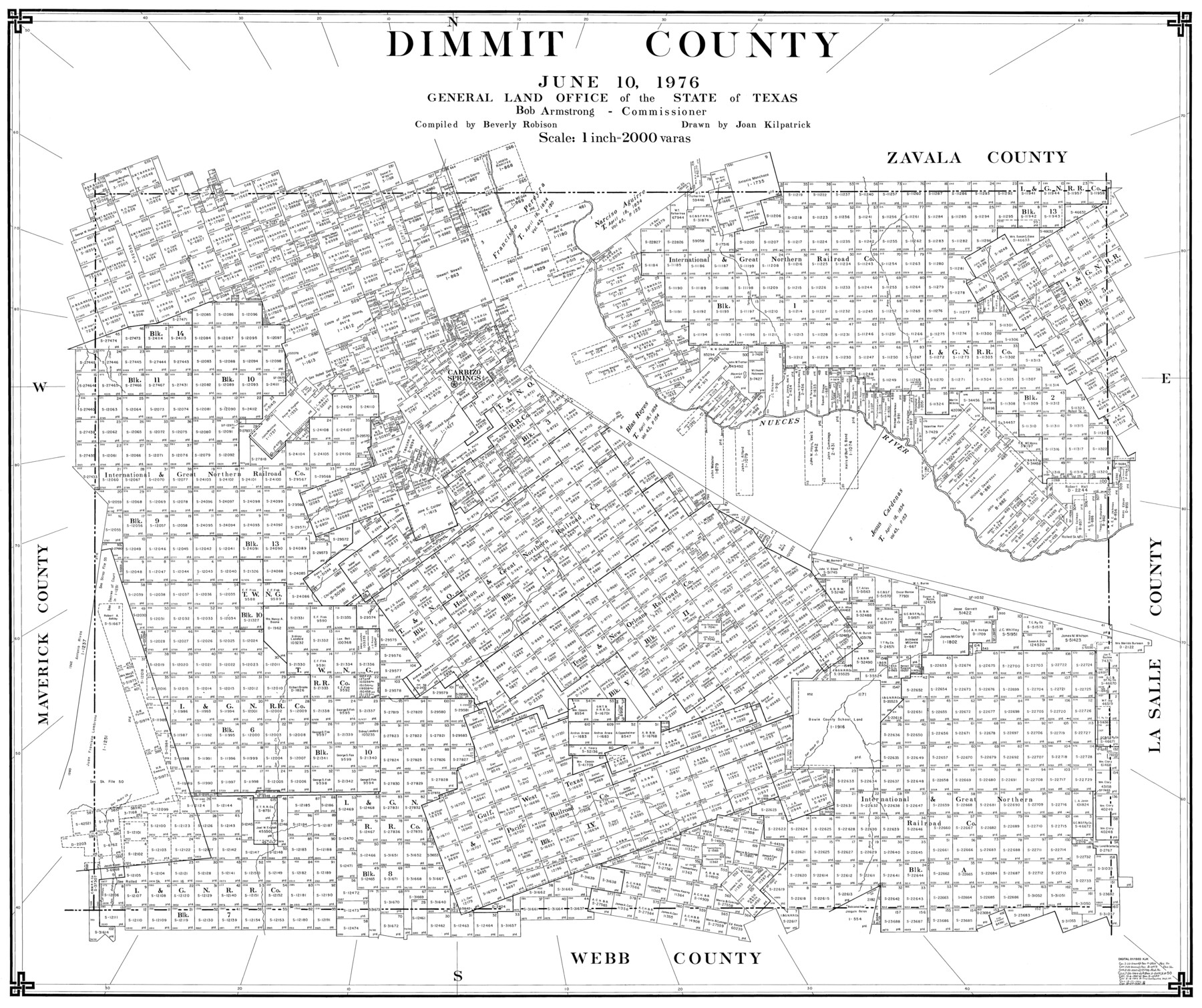
Dimmit County
-
Map/Doc
77265
-
Collection
General Map Collection
-
Object Dates
6/10/1976 (Creation Date)
-
People and Organizations
Beverly Robison (Compiler)
Joan Kilpatrick (Draftsman)
-
Counties
Dimmit
-
Subjects
County
-
Height x Width
42.2 x 48.9 inches
107.2 x 124.2 cm
-
Scale
1" = 2000 varas
Part of: General Map Collection
Menard County Working Sketch 19

Print $20.00
- Digital $50.00
Menard County Working Sketch 19
1948
Size 25.1 x 22.4 inches
Map/Doc 70966
Flight Mission No. CRC-4R, Frame 96, Chambers County

Print $20.00
- Digital $50.00
Flight Mission No. CRC-4R, Frame 96, Chambers County
1956
Size 18.4 x 22.2 inches
Map/Doc 84893
Sterling County Rolled Sketch X

Print $117.00
- Digital $50.00
Sterling County Rolled Sketch X
Size 15.3 x 9.6 inches
Map/Doc 49097
La Salle County Sketch File 45

Print $40.00
- Digital $50.00
La Salle County Sketch File 45
1939
Size 16.9 x 14.2 inches
Map/Doc 29601
Bexar County Boundary File 2a

Print $12.00
- Digital $50.00
Bexar County Boundary File 2a
Size 10.0 x 8.1 inches
Map/Doc 50530
Morris County Rolled Sketch 2A

Print $20.00
- Digital $50.00
Morris County Rolled Sketch 2A
Size 24.0 x 18.8 inches
Map/Doc 10274
Pecos County Rolled Sketch 151

Print $20.00
- Digital $50.00
Pecos County Rolled Sketch 151
Size 40.6 x 23.6 inches
Map/Doc 7281
Gaines County Rolled Sketch 15

Print $40.00
- Digital $50.00
Gaines County Rolled Sketch 15
Size 73.5 x 23.4 inches
Map/Doc 9035
[Surveys along Cypress Creek]
![155, [Surveys along Cypress Creek], General Map Collection](https://historictexasmaps.com/wmedia_w700/maps/155.tif.jpg)
Print $2.00
- Digital $50.00
[Surveys along Cypress Creek]
1844
Size 6.0 x 6.1 inches
Map/Doc 155
Uvalde County Working Sketch 68

Print $20.00
- Digital $50.00
Uvalde County Working Sketch 68
1971
Size 30.3 x 32.0 inches
Map/Doc 75974
Sterling County

Print $40.00
- Digital $50.00
Sterling County
1926
Size 48.5 x 34.7 inches
Map/Doc 63048

You may also like
Kaufman County Sketch File A

Print $4.00
- Digital $50.00
Kaufman County Sketch File A
1879
Size 14.1 x 8.8 inches
Map/Doc 28630
Bandera County Boundary File 6

Print $42.00
- Digital $50.00
Bandera County Boundary File 6
1972
Size 14.2 x 8.9 inches
Map/Doc 50303
Angelina County Sketch File 23a

Print $4.00
- Digital $50.00
Angelina County Sketch File 23a
1904
Size 11.2 x 8.6 inches
Map/Doc 13063
Zavala County Sketch File 24

Print $12.00
- Digital $50.00
Zavala County Sketch File 24
1885
Size 11.5 x 8.6 inches
Map/Doc 41382
Milam County Boundary File 6b

Print $40.00
- Digital $50.00
Milam County Boundary File 6b
Size 31.1 x 48.8 inches
Map/Doc 57249
Throckmorton County Rolled Sketch 3C

Print $20.00
- Digital $50.00
Throckmorton County Rolled Sketch 3C
Size 31.1 x 37.1 inches
Map/Doc 7989

Winkler County Rolled Sketch 11

Print $20.00
- Digital $50.00
Winkler County Rolled Sketch 11
1965
Size 37.4 x 34.2 inches
Map/Doc 10152
El Paso County Boundary File 6

Print $14.00
- Digital $50.00
El Paso County Boundary File 6
Size 14.0 x 8.8 inches
Map/Doc 53080
Dr. S. C. Arnett Farm Part Section 22, Block JS

Print $20.00
- Digital $50.00
Dr. S. C. Arnett Farm Part Section 22, Block JS
Size 16.0 x 18.7 inches
Map/Doc 92306
Waller County

Print $40.00
- Digital $50.00
Waller County
1945
Size 48.0 x 28.5 inches
Map/Doc 63108
Real County Working Sketch 3

Print $20.00
- Digital $50.00
Real County Working Sketch 3
Size 35.0 x 24.9 inches
Map/Doc 71895