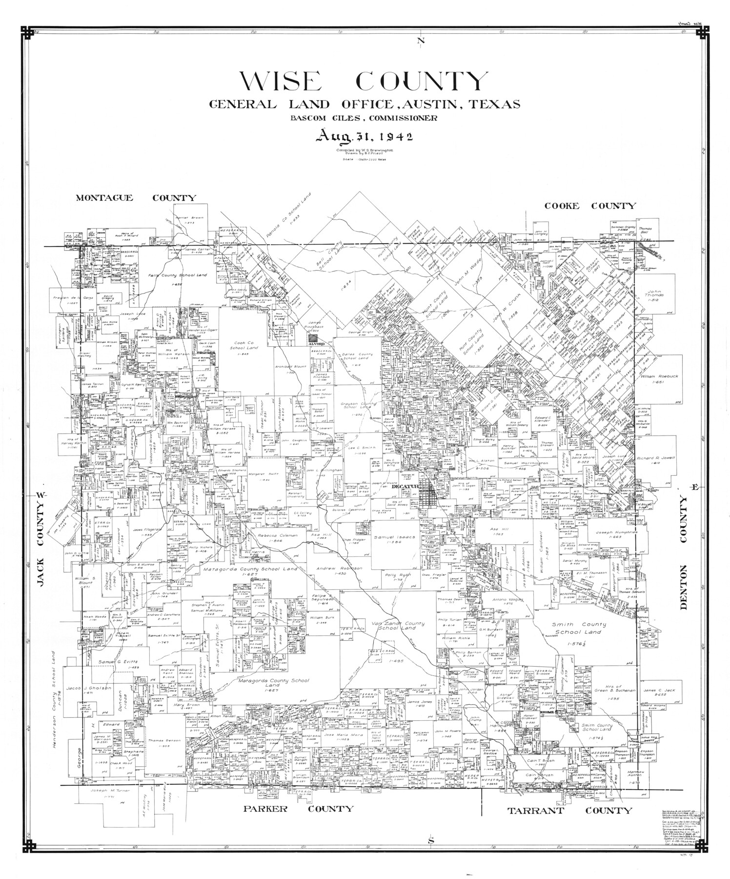
Wise County
-
Map/Doc
77463
-
Collection
General Map Collection
-
Object Dates
1942/8/31 (Creation Date)
-
People and Organizations
B.F. Priest (Draftsman)
W.S. Brewington (Compiler)
-
Counties
Wise
-
Subjects
County
-
Height x Width
45.9 x 38.2 inches
116.6 x 97.0 cm
Part of: General Map Collection
Angelina County Working Sketch 14
![67095, Angelina County Working Sketch 14, General Map Collection](https://historictexasmaps.com/wmedia_w700/maps/67095.tif.jpg)
Print $20.00
- Digital $50.00
Angelina County Working Sketch 14
1935
Size 29.6 x 34.9 inches
Map/Doc 67095
Llano County Sketch File 16
![30392, Llano County Sketch File 16, General Map Collection](https://historictexasmaps.com/wmedia_w700/pdf_converted_jpg/qi_pdf_thumbnail_12806.jpg)
Print $12.00
- Digital $50.00
Llano County Sketch File 16
1905
Size 12.3 x 11.3 inches
Map/Doc 30392
Packery Channel
![3005, Packery Channel, General Map Collection](https://historictexasmaps.com/wmedia_w700/maps/3005.tif.jpg)
Print $3.00
- Digital $50.00
Packery Channel
1962
Size 10.7 x 13.2 inches
Map/Doc 3005
Titus County Sketch File 13
![38154, Titus County Sketch File 13, General Map Collection](https://historictexasmaps.com/wmedia_w700/pdf_converted_jpg/qi_pdf_thumbnail_14524.jpg)
Print $6.00
- Digital $50.00
Titus County Sketch File 13
1929
Size 9.0 x 8.8 inches
Map/Doc 38154
Cass County Working Sketch 1
![67904, Cass County Working Sketch 1, General Map Collection](https://historictexasmaps.com/wmedia_w700/maps/67904.tif.jpg)
Print $20.00
- Digital $50.00
Cass County Working Sketch 1
Size 20.2 x 21.9 inches
Map/Doc 67904
Chambers County Aerial Photograph Index Sheet 6
![83687, Chambers County Aerial Photograph Index Sheet 6, General Map Collection](https://historictexasmaps.com/wmedia_w700/pdf_converted_jpg/qi_pdf_thumbnail_30908.jpg)
Print $20.00
- Digital $50.00
Chambers County Aerial Photograph Index Sheet 6
1956
Size 19.4 x 15.2 inches
Map/Doc 83687
Leon County Working Sketch 2
![70401, Leon County Working Sketch 2, General Map Collection](https://historictexasmaps.com/wmedia_w700/maps/70401.tif.jpg)
Print $20.00
- Digital $50.00
Leon County Working Sketch 2
Size 17.3 x 17.0 inches
Map/Doc 70401
Hays County Rolled Sketch 25
![6181, Hays County Rolled Sketch 25, General Map Collection](https://historictexasmaps.com/wmedia_w700/maps/6181.tif.jpg)
Print $20.00
- Digital $50.00
Hays County Rolled Sketch 25
1925
Size 17.5 x 40.0 inches
Map/Doc 6181
Newton County Rolled Sketch 23
![6850, Newton County Rolled Sketch 23, General Map Collection](https://historictexasmaps.com/wmedia_w700/maps/6850.tif.jpg)
Print $20.00
- Digital $50.00
Newton County Rolled Sketch 23
1893
Size 22.7 x 18.5 inches
Map/Doc 6850
Brooks County Rolled Sketch 18
![61786, Brooks County Rolled Sketch 18, General Map Collection](https://historictexasmaps.com/wmedia_w700/maps/61786.tif.jpg)
Print $20.00
- Digital $50.00
Brooks County Rolled Sketch 18
Size 11.3 x 16.1 inches
Map/Doc 61786
La Salle County Working Sketch 53
![67362, La Salle County Working Sketch 53, General Map Collection](https://historictexasmaps.com/wmedia_w700/maps/67362.tif.jpg)
Print $20.00
- Digital $50.00
La Salle County Working Sketch 53
Size 14.3 x 15.9 inches
Map/Doc 67362
Flight Mission No. DCL-7C, Frame 123, Kenedy County
![86088, Flight Mission No. DCL-7C, Frame 123, Kenedy County, General Map Collection](https://historictexasmaps.com/wmedia_w700/pdf_converted_jpg/qi_pdf_thumbnail_33233.jpg)
Print $20.00
- Digital $50.00
Flight Mission No. DCL-7C, Frame 123, Kenedy County
1943
Size 18.5 x 22.2 inches
Map/Doc 86088
You may also like
Garza County Sketch File 20
![24068, Garza County Sketch File 20, General Map Collection](https://historictexasmaps.com/wmedia_w700/pdf_converted_jpg/qi_pdf_thumbnail_11352.jpg)
Print $20.00
- Digital $50.00
Garza County Sketch File 20
1905
Size 8.7 x 7.8 inches
Map/Doc 24068
Right of Way and Track Map, Houston & Texas Central R.R. operated by the T. and N. O. R.R., Fort Worth Branch
![64784, Right of Way and Track Map, Houston & Texas Central R.R. operated by the T. and N. O. R.R., Fort Worth Branch, General Map Collection](https://historictexasmaps.com/wmedia_w700/maps/64784.tif.jpg)
Print $40.00
- Digital $50.00
Right of Way and Track Map, Houston & Texas Central R.R. operated by the T. and N. O. R.R., Fort Worth Branch
1918
Size 31.7 x 56.8 inches
Map/Doc 64784
Map of Washington County, Texas
![765, Map of Washington County, Texas, Maddox Collection](https://historictexasmaps.com/wmedia_w700/maps/765.tif.jpg)
Print $20.00
- Digital $50.00
Map of Washington County, Texas
1879
Size 14.4 x 21.6 inches
Map/Doc 765
Hale County Boundary File 2
![54044, Hale County Boundary File 2, General Map Collection](https://historictexasmaps.com/wmedia_w700/pdf_converted_jpg/qi_pdf_thumbnail_16123.jpg)
Print $4.00
- Digital $50.00
Hale County Boundary File 2
Size 10.9 x 8.8 inches
Map/Doc 54044
Goliad County Sketch File 23
![24295, Goliad County Sketch File 23, General Map Collection](https://historictexasmaps.com/wmedia_w700/pdf_converted_jpg/qi_pdf_thumbnail_11418.jpg)
Print $4.00
- Digital $50.00
Goliad County Sketch File 23
1877
Size 8.1 x 12.8 inches
Map/Doc 24295
Leon County Working Sketch 37
![70436, Leon County Working Sketch 37, General Map Collection](https://historictexasmaps.com/wmedia_w700/maps/70436.tif.jpg)
Print $20.00
- Digital $50.00
Leon County Working Sketch 37
Size 43.2 x 37.7 inches
Map/Doc 70436
Flight Mission No. CRC-3R, Frame 10, Chambers County
![84784, Flight Mission No. CRC-3R, Frame 10, Chambers County, General Map Collection](https://historictexasmaps.com/wmedia_w700/pdf_converted_jpg/qi_pdf_thumbnail_31999.jpg)
Print $20.00
- Digital $50.00
Flight Mission No. CRC-3R, Frame 10, Chambers County
1956
Size 18.5 x 22.2 inches
Map/Doc 84784
Bee County Working Sketch 20
![67270, Bee County Working Sketch 20, General Map Collection](https://historictexasmaps.com/wmedia_w700/maps/67270.tif.jpg)
Print $20.00
- Digital $50.00
Bee County Working Sketch 20
1982
Size 23.6 x 21.3 inches
Map/Doc 67270
Kinney County Sketch File 5
![29123, Kinney County Sketch File 5, General Map Collection](https://historictexasmaps.com/wmedia_w700/pdf_converted_jpg/qi_pdf_thumbnail_12485.jpg)
Print $2.00
- Digital $50.00
Kinney County Sketch File 5
Size 5.7 x 13.1 inches
Map/Doc 29123
Brewster County Working Sketch 89
![67689, Brewster County Working Sketch 89, General Map Collection](https://historictexasmaps.com/wmedia_w700/maps/67689.tif.jpg)
Print $20.00
- Digital $50.00
Brewster County Working Sketch 89
Size 20.5 x 44.1 inches
Map/Doc 67689
Lubbock County
![895, Lubbock County, General Map Collection](https://historictexasmaps.com/wmedia_w700/maps/895.tif.jpg)
Print $40.00
- Digital $50.00
Lubbock County
1915
Size 49.0 x 40.6 inches
Map/Doc 895
General Highway Map, Sterling County, Texas
![79661, General Highway Map, Sterling County, Texas, Texas State Library and Archives](https://historictexasmaps.com/wmedia_w700/maps/79661.tif.jpg)
Print $20.00
General Highway Map, Sterling County, Texas
1961
Size 24.8 x 18.1 inches
Map/Doc 79661