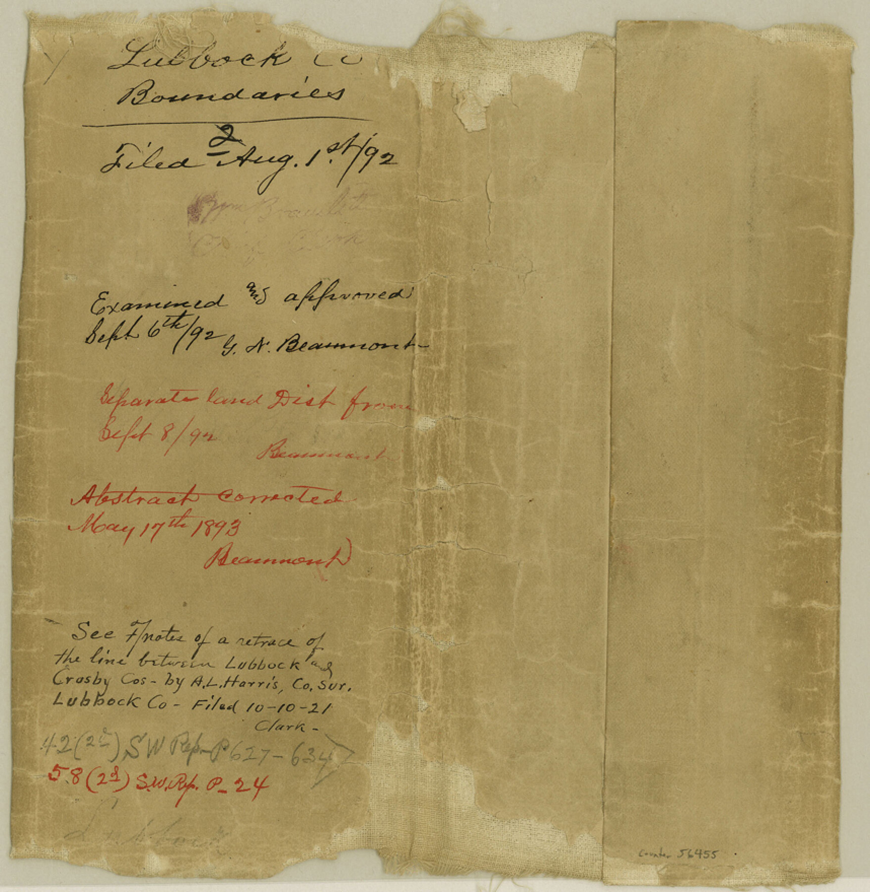
Lubbock County Boundary File 1
[Fieldnotes of North Boundary line of Lubbock County and South Boundary of Hale County; Fieldnotes of the County Boundary between Crosby and Lubbock Counties; Fieldnotes of the County Boundary between Lubbock and Lynn Counties; Fieldnotes of the West Boun
-
Map/Doc
56455
-
Collection
General Map Collection
-
Counties
Lubbock
-
Subjects
County Boundaries
-
Height x Width
8.8 x 8.6 inches
22.4 x 21.8 cm
Part of: General Map Collection
Comal County Sketch File 5

Print $4.00
- Digital $50.00
Comal County Sketch File 5
1848
Size 12.9 x 8.4 inches
Map/Doc 19006
Potter County Boundary File 6a

Print $20.00
- Digital $50.00
Potter County Boundary File 6a
Size 43.8 x 15.6 inches
Map/Doc 58039
Oldham County Rolled Sketch 2

Print $40.00
- Digital $50.00
Oldham County Rolled Sketch 2
1886
Size 35.7 x 55.1 inches
Map/Doc 9639
Menard County Boundary File 12a

Print $14.00
- Digital $50.00
Menard County Boundary File 12a
Size 14.2 x 8.8 inches
Map/Doc 57114
Map of Concho County

Print $20.00
- Digital $50.00
Map of Concho County
1879
Size 25.1 x 18.4 inches
Map/Doc 3436
Presidio County Working Sketch 111

Print $20.00
- Digital $50.00
Presidio County Working Sketch 111
1981
Size 17.1 x 20.4 inches
Map/Doc 71788
Galveston County Sketch File 34a

Print $20.00
- Digital $50.00
Galveston County Sketch File 34a
Size 11.4 x 20.3 inches
Map/Doc 11537
Williamson County Sketch File 24

Print $12.00
- Digital $50.00
Williamson County Sketch File 24
1877
Size 12.8 x 8.1 inches
Map/Doc 40355
Donley County Boundary File 3

Print $33.00
- Digital $50.00
Donley County Boundary File 3
Size 13.2 x 8.7 inches
Map/Doc 52623
Rio Grande, North Extension McAllen Sheet

Print $20.00
- Digital $50.00
Rio Grande, North Extension McAllen Sheet
1937
Size 18.5 x 42.1 inches
Map/Doc 65108
Limestone County Sketch File 23

Print $6.00
- Digital $50.00
Limestone County Sketch File 23
1908
Size 10.9 x 7.1 inches
Map/Doc 30203
Van Zandt County Sketch File 16

Print $4.00
- Digital $50.00
Van Zandt County Sketch File 16
1858
Size 6.8 x 8.0 inches
Map/Doc 39410
You may also like
McMullen County Working Sketch 43

Print $20.00
- Digital $50.00
McMullen County Working Sketch 43
1980
Size 35.2 x 28.1 inches
Map/Doc 70744
Harris County Sketch File 87

Print $20.00
- Digital $50.00
Harris County Sketch File 87
1895
Size 19.7 x 27.6 inches
Map/Doc 11675
Texas City Channel, Texas, Channel and Turning Basin Dredging - Sheet 4

Print $20.00
- Digital $50.00
Texas City Channel, Texas, Channel and Turning Basin Dredging - Sheet 4
1958
Size 28.5 x 40.9 inches
Map/Doc 61834
Crane County Rolled Sketch 14

Print $46.00
- Digital $50.00
Crane County Rolled Sketch 14
1935
Size 37.1 x 31.6 inches
Map/Doc 8680
Flight Mission No. DIX-7P, Frame 90, Aransas County

Print $20.00
- Digital $50.00
Flight Mission No. DIX-7P, Frame 90, Aransas County
1956
Size 18.8 x 22.4 inches
Map/Doc 83884
Flight Mission No. CUI-1H, Frame 96, Milam County

Print $20.00
- Digital $50.00
Flight Mission No. CUI-1H, Frame 96, Milam County
1951
Size 18.7 x 22.5 inches
Map/Doc 86604
Trinity County Rolled Sketch 5

Print $20.00
- Digital $50.00
Trinity County Rolled Sketch 5
1993
Size 25.3 x 38.0 inches
Map/Doc 8052
Reeves County Rolled Sketch 6

Print $20.00
- Digital $50.00
Reeves County Rolled Sketch 6
Size 22.6 x 29.0 inches
Map/Doc 7478
Mason County Sketch File 1

Print $6.00
- Digital $50.00
Mason County Sketch File 1
1857
Size 11.0 x 8.2 inches
Map/Doc 30677
Wilbarger County Working Sketch 4

Print $20.00
- Digital $50.00
Wilbarger County Working Sketch 4
1925
Size 14.6 x 17.1 inches
Map/Doc 72542
[Sketch for Mineral Application 16787 - Pecos River Bed, A. T. Freet]
![65631, [Sketch for Mineral Application 16787 - Pecos River Bed, A. T. Freet], General Map Collection](https://historictexasmaps.com/wmedia_w700/maps/65631-1.tif.jpg)
Print $40.00
- Digital $50.00
[Sketch for Mineral Application 16787 - Pecos River Bed, A. T. Freet]
Size 19.6 x 70.7 inches
Map/Doc 65631
Bandera County Working Sketch 57

Print $20.00
- Digital $50.00
Bandera County Working Sketch 57
1991
Size 38.5 x 46.8 inches
Map/Doc 67653