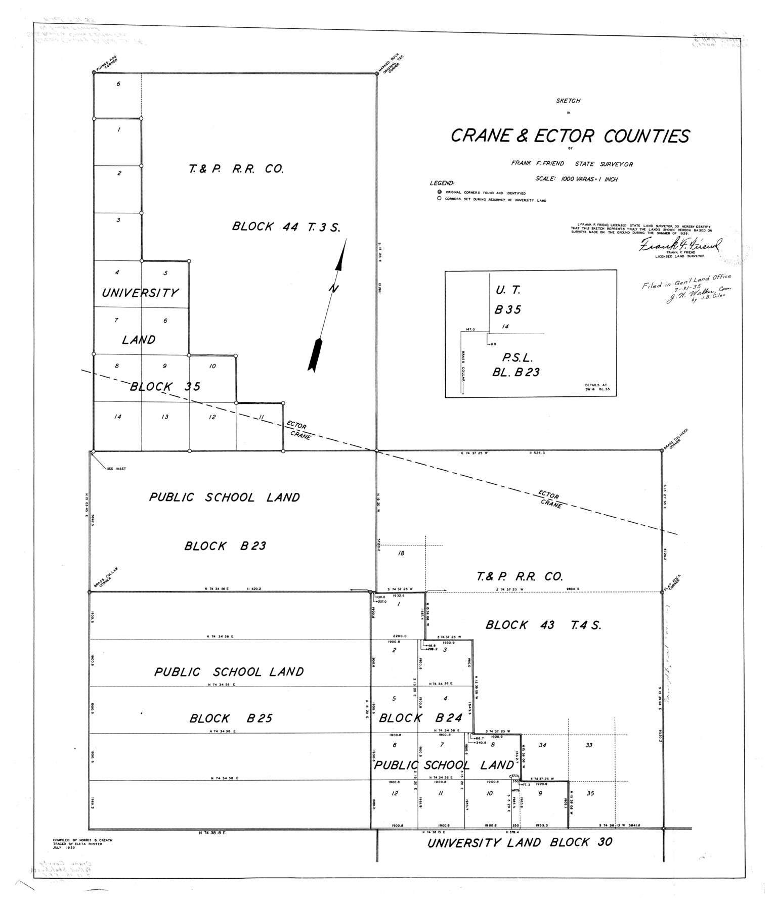
Crane County Rolled Sketch 14
Sketch in Crane & Ector Counties
-
Map/Doc
8680
-
Collection
General Map Collection
-
Object Dates
1935/7/27 (Creation Date)
1935/7/31 (File Date)
-
People and Organizations
Frank F. Friend (Surveyor/Engineer)
-
Counties
Crane Ector
-
Subjects
Surveying Rolled Sketch
-
Height x Width
37.1 x 31.6 inches
94.2 x 80.3 cm
-
Medium
multi-page, multi-format
-
Scale
1" = 1000 varas
Part of: General Map Collection
Waller County

Print $40.00
- Digital $50.00
Waller County
1945
Size 48.5 x 28.9 inches
Map/Doc 73315
Johnson's Military Map of the United States showing the Forts, Military Posts & all the Military Divisions with enlarged plans of southern harbors

Print $20.00
- Digital $50.00
Johnson's Military Map of the United States showing the Forts, Military Posts & all the Military Divisions with enlarged plans of southern harbors
1861
Map/Doc 93947
Wilson County Boundary File 2

Print $10.00
- Digital $50.00
Wilson County Boundary File 2
Size 12.3 x 8.3 inches
Map/Doc 60078

Flight Mission No. DAH-10M, Frame 40, Orange County

Print $20.00
- Digital $50.00
Flight Mission No. DAH-10M, Frame 40, Orange County
1953
Size 18.8 x 22.6 inches
Map/Doc 86875
Flight Mission No. BRE-5P, Frame 201, Nueces County

Print $20.00
- Digital $50.00
Flight Mission No. BRE-5P, Frame 201, Nueces County
1956
Size 18.5 x 22.6 inches
Map/Doc 86841
Pecos County Working Sketch 63

Print $20.00
- Digital $50.00
Pecos County Working Sketch 63
1954
Size 29.5 x 33.2 inches
Map/Doc 71535
El Paso County Rolled Sketch 66

Print $20.00
- Digital $50.00
El Paso County Rolled Sketch 66
2014
Size 35.1 x 41.2 inches
Map/Doc 93712
Flight Mission No. DAG-24K, Frame 151, Matagorda County

Print $20.00
- Digital $50.00
Flight Mission No. DAG-24K, Frame 151, Matagorda County
1953
Size 18.5 x 22.1 inches
Map/Doc 86565
In the Supreme Court of the United States, The State of Oklahoma, Complainant vs. The State of Texas, Defendant, The United States of America, Intervener, Red River Valley, Texas and Oklahoma Between the 98th and 100th Meridians in Five Sheets, 1921

Print $40.00
- Digital $50.00
In the Supreme Court of the United States, The State of Oklahoma, Complainant vs. The State of Texas, Defendant, The United States of America, Intervener, Red River Valley, Texas and Oklahoma Between the 98th and 100th Meridians in Five Sheets, 1921
1921
Size 38.6 x 60.0 inches
Map/Doc 75276
Culberson County Rolled Sketch 69

Print $20.00
- Digital $50.00
Culberson County Rolled Sketch 69
Size 33.5 x 22.9 inches
Map/Doc 76425
Calhoun County NRC Article 33.136 Sketch 14

Print $24.00
Calhoun County NRC Article 33.136 Sketch 14
2023
Map/Doc 97273
You may also like
Gregg County Working Sketch 25

Print $20.00
- Digital $50.00
Gregg County Working Sketch 25
2006
Size 22.6 x 34.0 inches
Map/Doc 83095
Walker County Sketch File 7

Print $4.00
- Digital $50.00
Walker County Sketch File 7
1838
Size 13.9 x 8.9 inches
Map/Doc 39559
Presidio County Working Sketch Graphic Index, West Part, Sheet 1 (Sketches 1 to 74)

Print $20.00
- Digital $50.00
Presidio County Working Sketch Graphic Index, West Part, Sheet 1 (Sketches 1 to 74)
1974
Size 40.3 x 31.4 inches
Map/Doc 76672
El Paso County Boundary File 14

Print $8.00
- Digital $50.00
El Paso County Boundary File 14
Size 13.0 x 8.6 inches
Map/Doc 53179
Jefferson County Rolled Sketch 27

Print $20.00
- Digital $50.00
Jefferson County Rolled Sketch 27
1948
Size 24.2 x 46.6 inches
Map/Doc 9292
Supreme Court of the United States, October Term, 1923, No. 15, Original - The State of Oklahoma, Complainant vs. The State of Texas, Defendant, The United States, Intervener; Report of the Boundary Commissioners

Print $98.00
- Digital $50.00
Supreme Court of the United States, October Term, 1923, No. 15, Original - The State of Oklahoma, Complainant vs. The State of Texas, Defendant, The United States, Intervener; Report of the Boundary Commissioners
1924
Size 6.1 x 9.2 inches
Map/Doc 3058
Gregg County Rolled Sketch 8A

Print $40.00
- Digital $50.00
Gregg County Rolled Sketch 8A
Size 25.5 x 50.3 inches
Map/Doc 9028
Johnson County Working Sketch 15

Print $20.00
- Digital $50.00
Johnson County Working Sketch 15
1974
Size 21.6 x 23.8 inches
Map/Doc 66628
J. C. Landon's Subdivision of Sherman County School Land situated in Cochran Co., Texas

Print $20.00
- Digital $50.00
J. C. Landon's Subdivision of Sherman County School Land situated in Cochran Co., Texas
1925
Size 14.1 x 22.9 inches
Map/Doc 90291
Trinity River, White Rock Creek Sheet

Print $6.00
- Digital $50.00
Trinity River, White Rock Creek Sheet
1923
Size 33.0 x 24.2 inches
Map/Doc 65198
Dimmit County Sketch File 10

Print $20.00
- Digital $50.00
Dimmit County Sketch File 10
Size 23.5 x 22.6 inches
Map/Doc 11338
Aransas County Sketch File 25

Print $20.00
- Digital $50.00
Aransas County Sketch File 25
Size 17.0 x 17.5 inches
Map/Doc 13218