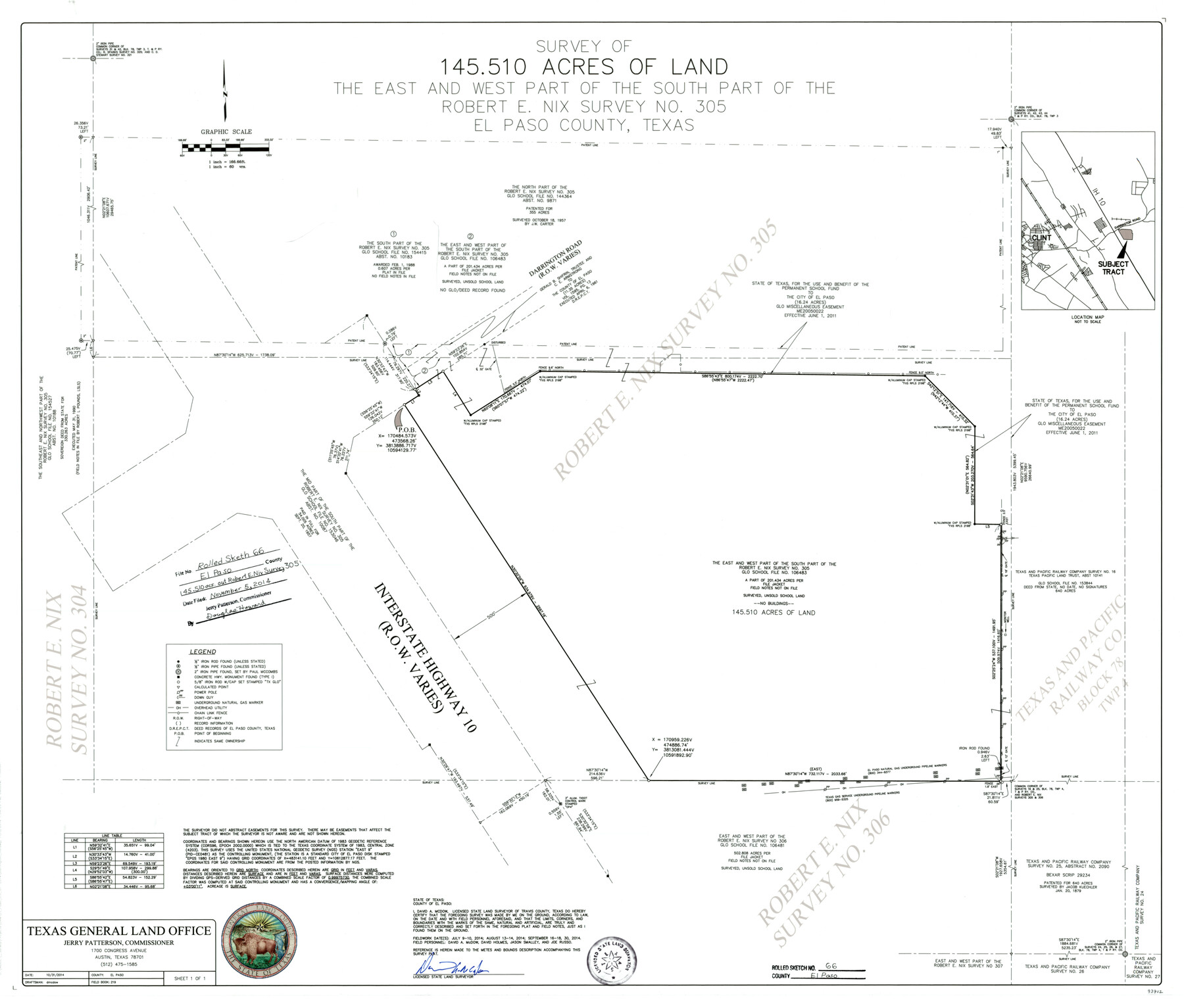
El Paso County Rolled Sketch 66
Survey of 145.510 acres of land - the east and west part of the south part of the Robert E. Nix Survey No. 305
-
Map/Doc
93712
-
Collection
General Map Collection
-
Object Dates
10/31/2014 (Creation Date)
11/5/2014 (File Date)
-
People and Organizations
Jerry E. Patterson (GLO Commissioner)
David A. McDow (Surveyor/Engineer)
David A. McDow (Draftsman)
-
Counties
El Paso
-
Subjects
Surveying Rolled Sketch
-
Height x Width
35.1 x 41.2 inches
89.2 x 104.7 cm
-
Medium
mylar, print
-
Scale
1" = 60 varas
Part of: General Map Collection
Burnet County Working Sketch 27

Print $20.00
- Digital $50.00
Burnet County Working Sketch 27
2025
Size 24.5 x 36.0 inches
Map/Doc 97419
Crockett County Rolled Sketch 46C

Print $20.00
- Digital $50.00
Crockett County Rolled Sketch 46C
Size 24.5 x 23.8 inches
Map/Doc 5595
Flight Mission No. BRA-7M, Frame 84, Jefferson County

Print $20.00
- Digital $50.00
Flight Mission No. BRA-7M, Frame 84, Jefferson County
1953
Size 18.6 x 22.3 inches
Map/Doc 85506
Flight Mission No. DQN-2K, Frame 187, Calhoun County

Print $20.00
- Digital $50.00
Flight Mission No. DQN-2K, Frame 187, Calhoun County
1953
Size 18.4 x 22.2 inches
Map/Doc 84328
Grimes County Working Sketch 8

Print $20.00
- Digital $50.00
Grimes County Working Sketch 8
1976
Size 35.0 x 32.7 inches
Map/Doc 63299
Carson County Boundary File 9

Print $74.00
- Digital $50.00
Carson County Boundary File 9
Size 9.0 x 8.9 inches
Map/Doc 51175
Flight Mission No. BRA-9M, Frame 74, Jefferson County

Print $20.00
- Digital $50.00
Flight Mission No. BRA-9M, Frame 74, Jefferson County
1953
Size 18.6 x 22.4 inches
Map/Doc 85657
Crockett County Sketch File H

Print $26.00
- Digital $50.00
Crockett County Sketch File H
1920
Size 14.4 x 9.0 inches
Map/Doc 19638
Val Verde County Working Sketch 83

Print $40.00
- Digital $50.00
Val Verde County Working Sketch 83
1973
Size 28.7 x 53.6 inches
Map/Doc 72218
Kenedy County Sketch File 1

Print $68.00
- Digital $50.00
Kenedy County Sketch File 1
1950
Size 14.2 x 8.8 inches
Map/Doc 28739
Pecos County Working Sketch 19

Print $20.00
- Digital $50.00
Pecos County Working Sketch 19
1917
Size 21.0 x 14.6 inches
Map/Doc 71489
Flight Mission No. DIX-10P, Frame 77, Aransas County

Print $20.00
- Digital $50.00
Flight Mission No. DIX-10P, Frame 77, Aransas County
1956
Size 18.6 x 22.3 inches
Map/Doc 83938
You may also like
General Highway Map, Coke County, Texas

Print $20.00
General Highway Map, Coke County, Texas
1961
Size 18.2 x 24.7 inches
Map/Doc 79411
Taylor County Working Sketch 18

Print $20.00
- Digital $50.00
Taylor County Working Sketch 18
1985
Size 43.2 x 46.0 inches
Map/Doc 69628
Foard County Working Sketch 1

Print $20.00
- Digital $50.00
Foard County Working Sketch 1
1899
Size 20.5 x 22.8 inches
Map/Doc 69191
Navarro County Working Sketch 3

Print $40.00
- Digital $50.00
Navarro County Working Sketch 3
1921
Size 43.8 x 64.6 inches
Map/Doc 71233
[Palmer, Bailey, Lamb, and Cochran Counties]
![92474, [Palmer, Bailey, Lamb, and Cochran Counties], Twichell Survey Records](https://historictexasmaps.com/wmedia_w700/maps/92474-1.tif.jpg)
Print $20.00
- Digital $50.00
[Palmer, Bailey, Lamb, and Cochran Counties]
Size 15.3 x 19.3 inches
Map/Doc 92474
Galveston County Rolled Sketch 25

Print $20.00
- Digital $50.00
Galveston County Rolled Sketch 25
1965
Size 18.6 x 24.2 inches
Map/Doc 5961
Donley County

Print $20.00
- Digital $50.00
Donley County
1944
Size 46.8 x 40.6 inches
Map/Doc 95484
Trinity County Sketch File 5b

Print $4.00
- Digital $50.00
Trinity County Sketch File 5b
1855
Size 12.6 x 8.0 inches
Map/Doc 38506

Flight Mission No. CLL-3N, Frame 8, Willacy County

Print $20.00
- Digital $50.00
Flight Mission No. CLL-3N, Frame 8, Willacy County
1954
Size 18.5 x 22.2 inches
Map/Doc 87074
Map of the City of Aransas Pass

Print $20.00
- Digital $50.00
Map of the City of Aransas Pass
Size 24.0 x 26.2 inches
Map/Doc 6871
