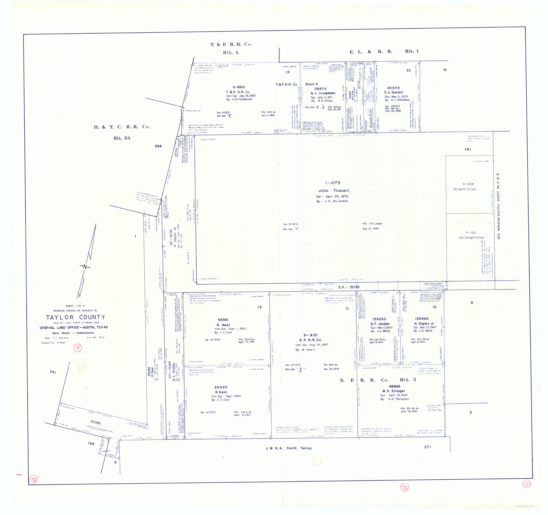
Taylor County Working Sketch 18
-
Map/Doc
69628
-
Collection
General Map Collection
-
Object Dates
2/11/1985 (Creation Date)
-
People and Organizations
Rosendo V. Molina (Draftsman)
-
Counties
Taylor
-
Subjects
Surveying Working Sketch
-
Height x Width
43.2 x 46.0 inches
109.7 x 116.8 cm
-
Scale
1" = 200 varas
Part of: General Map Collection
Map of Hutchinson County

Print $20.00
- Digital $50.00
Map of Hutchinson County
1898
Size 41.0 x 35.4 inches
Map/Doc 16856
Donley County Boundary File 2

Print $10.00
- Digital $50.00
Donley County Boundary File 2
Size 8.7 x 11.3 inches
Map/Doc 52619
Louisiana and Texas Intracoastal Waterway, Section 7, Galveston Bay to Brazos River and Section 8, Brazos River to Matagorda Bay

Print $20.00
- Digital $50.00
Louisiana and Texas Intracoastal Waterway, Section 7, Galveston Bay to Brazos River and Section 8, Brazos River to Matagorda Bay
1928
Size 30.8 x 42.9 inches
Map/Doc 61839
Flight Mission No. CRC-3R, Frame 45, Chambers County

Print $20.00
- Digital $50.00
Flight Mission No. CRC-3R, Frame 45, Chambers County
1956
Size 18.6 x 22.5 inches
Map/Doc 84818
San Jacinto County Working Sketch 21

Print $20.00
- Digital $50.00
San Jacinto County Working Sketch 21
1939
Size 32.1 x 25.5 inches
Map/Doc 63734
Hamilton County Working Sketch Graphic Index

Print $20.00
- Digital $50.00
Hamilton County Working Sketch Graphic Index
1972
Size 34.3 x 39.8 inches
Map/Doc 76564
G. C. & S. F. Ry. Alinement [sic] and Right of Way Map of Dallas Branch, Johnson County, Texas
![64652, G. C. & S. F. Ry. Alinement [sic] and Right of Way Map of Dallas Branch, Johnson County, Texas, General Map Collection](https://historictexasmaps.com/wmedia_w700/maps/64652.tif.jpg)
Print $40.00
- Digital $50.00
G. C. & S. F. Ry. Alinement [sic] and Right of Way Map of Dallas Branch, Johnson County, Texas
1925
Size 37.6 x 87.9 inches
Map/Doc 64652
Tyler County Working Sketch 18

Print $20.00
- Digital $50.00
Tyler County Working Sketch 18
1965
Size 31.4 x 27.3 inches
Map/Doc 69488
Map of Young County

Print $20.00
- Digital $50.00
Map of Young County
1880
Size 22.0 x 20.3 inches
Map/Doc 4174
Stonewall County Sketch File 6

Print $10.00
- Digital $50.00
Stonewall County Sketch File 6
1891
Size 14.0 x 8.7 inches
Map/Doc 37208
Mexico or New Spain in which the Motions of Cortes may be traced

Print $20.00
- Digital $50.00
Mexico or New Spain in which the Motions of Cortes may be traced
1795
Size 14.5 x 16.5 inches
Map/Doc 93650
Hockley County Sketch File 5

Print $4.00
- Digital $50.00
Hockley County Sketch File 5
Size 9.1 x 11.2 inches
Map/Doc 26539
You may also like
Wise County Working Sketch 20

Print $20.00
- Digital $50.00
Wise County Working Sketch 20
1979
Size 22.8 x 27.3 inches
Map/Doc 72634
Map of parts of Texas, Mexico and New Mexico

Print $4.00
- Digital $50.00
Map of parts of Texas, Mexico and New Mexico
1877
Size 18.1 x 21.8 inches
Map/Doc 65403
Tom Green County Rolled Sketch 24

Print $20.00
- Digital $50.00
Tom Green County Rolled Sketch 24
Size 14.4 x 19.1 inches
Map/Doc 8006
Coleman County Working Sketch 22

Print $20.00
- Digital $50.00
Coleman County Working Sketch 22
1953
Size 34.6 x 41.0 inches
Map/Doc 68088
Tom Green County Boundary File 3

Print $30.00
- Digital $50.00
Tom Green County Boundary File 3
Size 14.4 x 8.7 inches
Map/Doc 59341

Cottle County Sketch File AA1

Print $95.00
- Digital $50.00
Cottle County Sketch File AA1
1895
Size 9.4 x 4.2 inches
Map/Doc 19398
Falls County State Real Property Sketch 1

Print $40.00
- Digital $50.00
Falls County State Real Property Sketch 1
1999
Size 23.6 x 23.5 inches
Map/Doc 61669
Webb County Sketch File 8-1

Print $20.00
- Digital $50.00
Webb County Sketch File 8-1
1929
Size 38.3 x 31.1 inches
Map/Doc 10429
Crockett County Sketch File 69

Print $6.00
- Digital $50.00
Crockett County Sketch File 69
1931
Size 14.5 x 8.9 inches
Map/Doc 19855
J. De Cordova's Map of the State of Texas Compiled from the records of the General Land Office of the State

Print $20.00
- Digital $50.00
J. De Cordova's Map of the State of Texas Compiled from the records of the General Land Office of the State
1849
Size 33.9 x 32.1 inches
Map/Doc 7826
Montgomery County Working Sketch 46

Print $20.00
- Digital $50.00
Montgomery County Working Sketch 46
1957
Size 25.6 x 28.1 inches
Map/Doc 71153