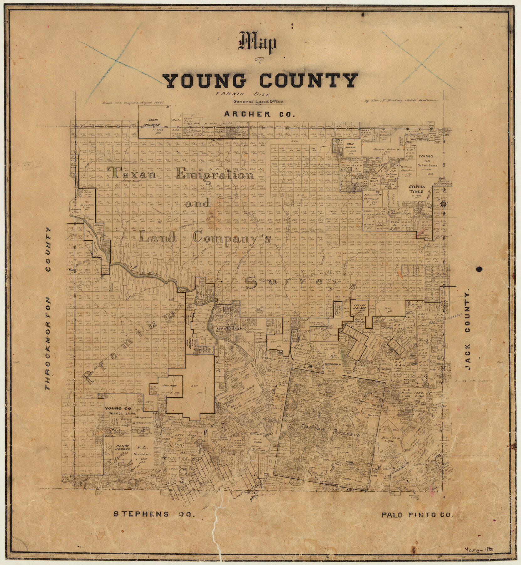
Map of Young County
-
Map/Doc
4174
-
Collection
General Map Collection
-
Object Dates
1880 (Creation Date)
-
People and Organizations
Texas General Land Office (Publisher)
Theo. F. Pinckney (Draftsman)
Theo. F. Pinckney (Compiler)
-
Counties
Young
-
Subjects
County
-
Height x Width
22.0 x 20.3 inches
55.9 x 51.6 cm
-
Features
Cedar Creek
Elm Creek
Briar Creek
Old Fort Worth Road
Fort Belknap
Six Mile Creek
Phantom Hill Road
Graham
Brazos River
Marcy's Creek
Conner's Creek
Fish Creek
Cove Creek
Fort Belknap
Tackhil Mountain
Clear Fork of Brazos River
Bottom Branch [of Brazos River]
Oak Creek
Brushy Creek
Camp Creek
Deep Creek
Wildcat Creek
California Road
Salt Creek
Little Salt Creek
Crooked Creek
School Creek
Pleasant Creek
Preston Road
Cotton Creek
Paint Creek
Salt Fork of Brazos River
Boggy Creek
Race Creek
Part of: General Map Collection
[Gulf Colorado & Santa Fe from 2178+36.0 to 3901+06.2]
![64695, [Gulf Colorado & Santa Fe from 2178+36.0 to 3901+06.2], General Map Collection](https://historictexasmaps.com/wmedia_w700/maps/64695-1.tif.jpg)
Print $40.00
- Digital $50.00
[Gulf Colorado & Santa Fe from 2178+36.0 to 3901+06.2]
Size 33.6 x 120.7 inches
Map/Doc 64695
Kerr County Working Sketch 31

Print $20.00
- Digital $50.00
Kerr County Working Sketch 31
1973
Size 43.6 x 29.0 inches
Map/Doc 70062
Southern Part of Laguna Madre

Print $20.00
- Digital $50.00
Southern Part of Laguna Madre
1985
Size 45.3 x 36.6 inches
Map/Doc 73547
Hood County Sketch File 1

Print $5.00
- Digital $50.00
Hood County Sketch File 1
Size 11.0 x 15.2 inches
Map/Doc 26569
Mills County Sketch File 18

Print $4.00
- Digital $50.00
Mills County Sketch File 18
1872
Size 12.1 x 8.1 inches
Map/Doc 31668
Martin County Working Sketch 6

Print $20.00
- Digital $50.00
Martin County Working Sketch 6
1971
Size 41.8 x 36.9 inches
Map/Doc 70824
Nueces County Aerial Photograph Index Sheet 5

Print $20.00
- Digital $50.00
Nueces County Aerial Photograph Index Sheet 5
1956
Size 19.5 x 23.4 inches
Map/Doc 83738
San Jacinto County Rolled Sketch 14

Print $20.00
- Digital $50.00
San Jacinto County Rolled Sketch 14
1998
Size 28.0 x 40.0 inches
Map/Doc 7565
Floyd County Boundary File 2b

Print $40.00
- Digital $50.00
Floyd County Boundary File 2b
Size 38.9 x 20.1 inches
Map/Doc 53490
Wichita County Sketch File 13a

Print $6.00
- Digital $50.00
Wichita County Sketch File 13a
1881
Size 9.4 x 6.0 inches
Map/Doc 40084
Val Verde County Sketch File Z3

Print $12.00
- Digital $50.00
Val Verde County Sketch File Z3
Size 8.8 x 7.8 inches
Map/Doc 39131
Coryell County Rolled Sketch 1

Print $20.00
- Digital $50.00
Coryell County Rolled Sketch 1
1943
Size 22.7 x 21.4 inches
Map/Doc 5565
You may also like
Map of the Mirror's Addition to the town of Amarillo, Potter County, Texas on the line of the Fort Worth and Denver City Ry.

Print $20.00
- Digital $50.00
Map of the Mirror's Addition to the town of Amarillo, Potter County, Texas on the line of the Fort Worth and Denver City Ry.
Size 13.3 x 20.1 inches
Map/Doc 91787
Crockett County Rolled Sketch CRV

Print $40.00
- Digital $50.00
Crockett County Rolled Sketch CRV
1925
Size 35.8 x 52.3 inches
Map/Doc 8693
Jones County Sketch File 2

Print $20.00
- Digital $50.00
Jones County Sketch File 2
1857
Size 16.8 x 21.1 inches
Map/Doc 11895
Outer Continental Shelf Leasing Maps (Texas Offshore Operations)

Print $20.00
- Digital $50.00
Outer Continental Shelf Leasing Maps (Texas Offshore Operations)
1954
Size 20.3 x 15.5 inches
Map/Doc 75839
Medina County

Print $40.00
- Digital $50.00
Medina County
1976
Size 52.5 x 43.2 inches
Map/Doc 73237
Hardin County Rolled Sketch 18

Print $20.00
- Digital $50.00
Hardin County Rolled Sketch 18
1953
Size 35.8 x 24.4 inches
Map/Doc 6088
Flight Mission No. DQO-8K, Frame 135, Galveston County

Print $20.00
- Digital $50.00
Flight Mission No. DQO-8K, Frame 135, Galveston County
1952
Size 18.7 x 22.5 inches
Map/Doc 85200
Newton County Working Sketch 9

Print $20.00
- Digital $50.00
Newton County Working Sketch 9
1938
Size 21.3 x 37.1 inches
Map/Doc 71255
Duval County Working Sketch 19

Print $20.00
- Digital $50.00
Duval County Working Sketch 19
1940
Size 21.7 x 18.5 inches
Map/Doc 68732
G & H Blocks, Gaines County, Texas Resurvey

Print $40.00
- Digital $50.00
G & H Blocks, Gaines County, Texas Resurvey
1915
Size 57.4 x 33.9 inches
Map/Doc 89669
Gulf Coast of the United States, Key West to Rio Grande

Print $20.00
- Digital $50.00
Gulf Coast of the United States, Key West to Rio Grande
1863
Size 27.3 x 18.2 inches
Map/Doc 72663
[Texas & Pacific Railway through Callahan County]
![64236, [Texas & Pacific Railway through Callahan County], General Map Collection](https://historictexasmaps.com/wmedia_w700/maps/64236.tif.jpg)
Print $20.00
- Digital $50.00
[Texas & Pacific Railway through Callahan County]
1918
Size 22.9 x 8.8 inches
Map/Doc 64236