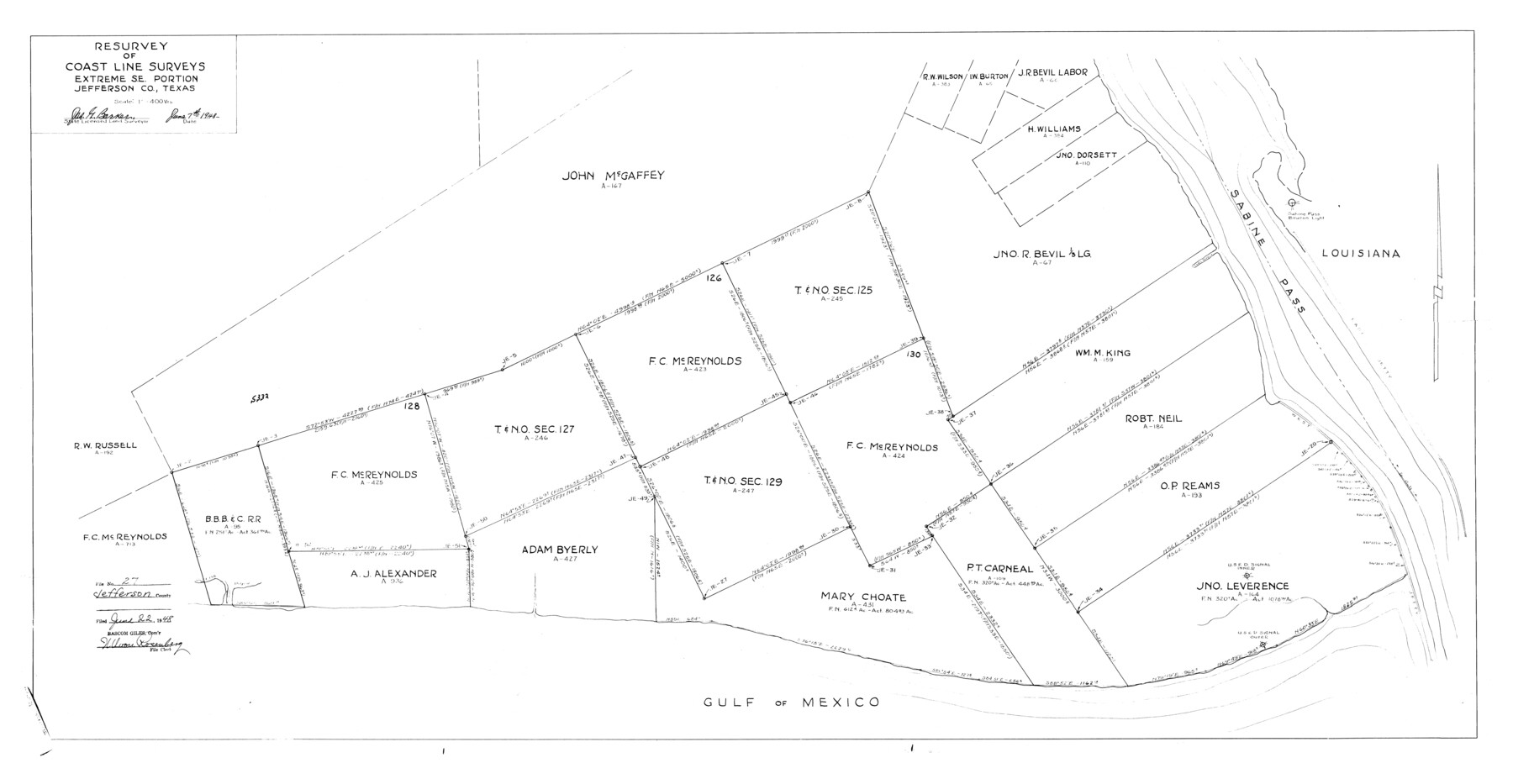
Jefferson County Rolled Sketch 27
Resurvey of coast line surveys, extreme SE portion Jefferson Co., Texas
-
Map/Doc
9292
-
Collection
General Map Collection
-
Object Dates
1948/6/7 (Creation Date)
1948/6/22 (File Date)
-
People and Organizations
Jas. G. Barker (Surveyor/Engineer)
-
Counties
Jefferson
-
Subjects
Surveying Rolled Sketch
-
Height x Width
24.2 x 46.6 inches
61.5 x 118.4 cm
-
Scale
1" = 400 varas
Part of: General Map Collection
Hutchinson County Boundary File 5

Print $22.00
- Digital $50.00
Hutchinson County Boundary File 5
Size 4.3 x 45.7 inches
Map/Doc 55314
Jefferson County Working Sketch 18

Print $20.00
- Digital $50.00
Jefferson County Working Sketch 18
1954
Size 24.2 x 30.7 inches
Map/Doc 66561
Real County Sketch File 11

Print $8.00
- Digital $50.00
Real County Sketch File 11
1932
Size 11.2 x 8.8 inches
Map/Doc 35065
Val Verde County Sketch File XXX8

Print $6.00
- Digital $50.00
Val Verde County Sketch File XXX8
Size 9.0 x 16.4 inches
Map/Doc 39106
Flight Mission No. DQN-2K, Frame 78, Calhoun County

Print $20.00
- Digital $50.00
Flight Mission No. DQN-2K, Frame 78, Calhoun County
1953
Size 18.6 x 22.3 inches
Map/Doc 84270
Stonewall County

Print $20.00
- Digital $50.00
Stonewall County
1933
Size 40.3 x 34.5 inches
Map/Doc 77428
Current Miscellaneous File 24a

Print $8.00
- Digital $50.00
Current Miscellaneous File 24a
1949
Size 11.0 x 8.6 inches
Map/Doc 73893
Kinney County Working Sketch 35

Print $40.00
- Digital $50.00
Kinney County Working Sketch 35
1965
Size 58.3 x 48.6 inches
Map/Doc 70217
Kenedy County Aerial Photograph Index Sheet 2

Print $20.00
- Digital $50.00
Kenedy County Aerial Photograph Index Sheet 2
1943
Size 23.1 x 19.3 inches
Map/Doc 83714
Duval County Rolled Sketch 17

Print $20.00
- Digital $50.00
Duval County Rolled Sketch 17
1940
Size 18.9 x 17.9 inches
Map/Doc 5738
Young County Working Sketch 7

Print $20.00
- Digital $50.00
Young County Working Sketch 7
1919
Size 24.3 x 19.8 inches
Map/Doc 62030
Chambers County Sketch File 50

Print $49.00
- Digital $50.00
Chambers County Sketch File 50
1917
Size 14.4 x 8.8 inches
Map/Doc 18048
You may also like
Mason County Sketch File 1

Print $6.00
- Digital $50.00
Mason County Sketch File 1
1857
Size 11.0 x 8.2 inches
Map/Doc 30677

Tarrant County Working Sketch 22

Print $20.00
- Digital $50.00
Tarrant County Working Sketch 22
2001
Size 27.5 x 23.0 inches
Map/Doc 62439
Collin County Working Sketch 1

Print $20.00
- Digital $50.00
Collin County Working Sketch 1
1921
Size 26.6 x 23.4 inches
Map/Doc 68095
Hockley County Boundary File 3

Print $12.00
- Digital $50.00
Hockley County Boundary File 3
Size 4.1 x 8.6 inches
Map/Doc 54804
General Highway Map, Franklin County, Texas

Print $20.00
General Highway Map, Franklin County, Texas
1961
Size 18.1 x 24.5 inches
Map/Doc 79471
Louisiana and Texas Intracoastal Waterway - Dredging from Freeport Harbor to Caney Creek - Sheet 2

Print $20.00
- Digital $50.00
Louisiana and Texas Intracoastal Waterway - Dredging from Freeport Harbor to Caney Creek - Sheet 2
1940
Size 31.2 x 41.3 inches
Map/Doc 61817
Hays County Sketch File 1

Print $2.00
- Digital $50.00
Hays County Sketch File 1
1856
Size 12.6 x 8.3 inches
Map/Doc 26199
Martin County Working Sketch 13

Print $40.00
- Digital $50.00
Martin County Working Sketch 13
1971
Size 50.8 x 37.5 inches
Map/Doc 70831
Flight Mission No. DQO-11K, Frame 16, Galveston County

Print $20.00
- Digital $50.00
Flight Mission No. DQO-11K, Frame 16, Galveston County
1952
Size 18.8 x 22.5 inches
Map/Doc 85209
Pecos County Rolled Sketch 22

Print $40.00
- Digital $50.00
Pecos County Rolled Sketch 22
1886
Size 73.4 x 45.2 inches
Map/Doc 93461
[Charles Welch, J. D. Brown, and surrounding surveys]
![91010, [Charles Welch, J. D. Brown, and surrounding surveys], Twichell Survey Records](https://historictexasmaps.com/wmedia_w700/maps/91010-1.tif.jpg)
Print $20.00
- Digital $50.00
[Charles Welch, J. D. Brown, and surrounding surveys]
Size 37.4 x 24.0 inches
Map/Doc 91010