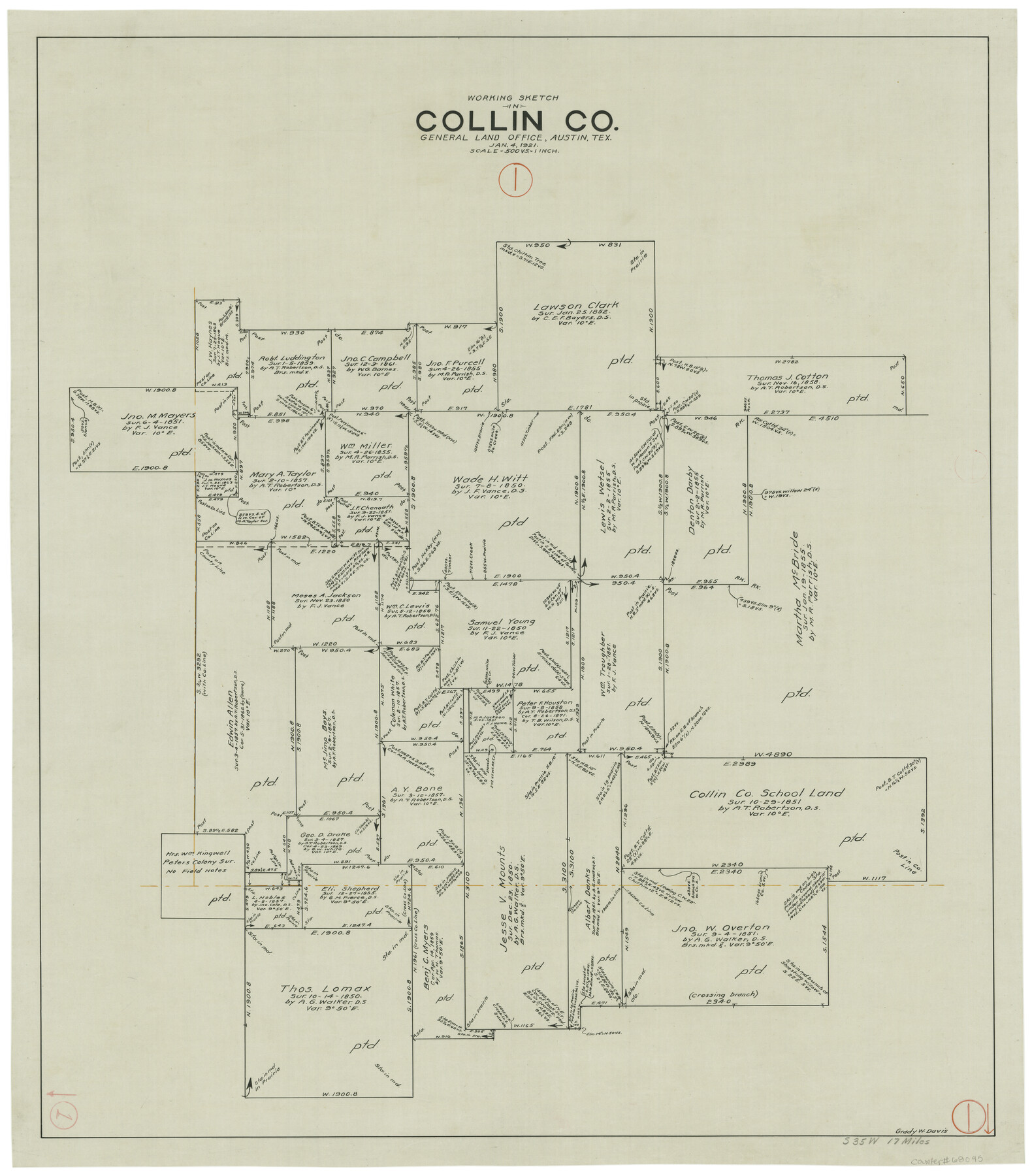
Collin County Working Sketch 1
-
Map/Doc
68095
-
Collection
General Map Collection
-
Object Dates
1/4/1921 (Creation Date)
-
People and Organizations
Grady W. Davis (Draftsman)
-
Counties
Collin
-
Subjects
Surveying Working Sketch
-
Height x Width
26.6 x 23.4 inches
67.6 x 59.4 cm
-
Scale
1" = 500 varas
Part of: General Map Collection
Right of Way and Track Map Houston & Texas Central R.R. operated by the T. and N. O. R.R. Co., Fort Worth Branch

Print $40.00
- Digital $50.00
Right of Way and Track Map Houston & Texas Central R.R. operated by the T. and N. O. R.R. Co., Fort Worth Branch
1918
Size 31.3 x 57.1 inches
Map/Doc 64539
Wharton County Rolled Sketch 13

Print $20.00
- Digital $50.00
Wharton County Rolled Sketch 13
1990
Size 22.4 x 28.1 inches
Map/Doc 8238
Brewster County Rolled Sketch 60

Print $20.00
- Digital $50.00
Brewster County Rolled Sketch 60
Size 25.0 x 37.5 inches
Map/Doc 8484

Hutchinson County Sketch File 6

Print $8.00
- Digital $50.00
Hutchinson County Sketch File 6
1890
Size 10.9 x 8.4 inches
Map/Doc 27198
Amistad International Reservoir on Rio Grande 93

Print $20.00
- Digital $50.00
Amistad International Reservoir on Rio Grande 93
1950
Size 28.5 x 40.7 inches
Map/Doc 75523
Brazoria County NRC Article 33.136 Sketch 3

Print $20.00
- Digital $50.00
Brazoria County NRC Article 33.136 Sketch 3
2002
Size 40.6 x 29.6 inches
Map/Doc 77039
Coryell County Working Sketch 26

Print $20.00
- Digital $50.00
Coryell County Working Sketch 26
1988
Size 30.7 x 30.6 inches
Map/Doc 68233
Throckmorton County Sketch File 14

Print $16.00
- Digital $50.00
Throckmorton County Sketch File 14
2004
Size 11.0 x 8.5 inches
Map/Doc 82481
Hoffman & Walker's Pictorial, Historical Map of Texas

Hoffman & Walker's Pictorial, Historical Map of Texas
1960
Size 44.0 x 45.5 inches
Map/Doc 2122
Gonzales County Sketch File 2

Print $10.00
- Digital $50.00
Gonzales County Sketch File 2
Size 8.9 x 7.8 inches
Map/Doc 24357
Parker County Sketch File 4

Print $6.00
- Digital $50.00
Parker County Sketch File 4
1856
Size 6.2 x 5.8 inches
Map/Doc 33525
You may also like
Brazos County Sketch File 3

Print $6.00
- Digital $50.00
Brazos County Sketch File 3
1861
Size 11.1 x 8.0 inches
Map/Doc 15554
Morris County Rolled Sketch 2A

Print $20.00
- Digital $50.00
Morris County Rolled Sketch 2A
Size 22.7 x 17.7 inches
Map/Doc 10227
Austin Old and New, a Mapguide to the Heart of the City including Capitol Complex & Government Buildings, Downtown Streets and Buildings, the University of Texas, Historical Sites, Parks & Trails, Sixth Street, Town Lake, Museums

Austin Old and New, a Mapguide to the Heart of the City including Capitol Complex & Government Buildings, Downtown Streets and Buildings, the University of Texas, Historical Sites, Parks & Trails, Sixth Street, Town Lake, Museums
Size 25.4 x 31.3 inches
Map/Doc 94379
Terry County Sketch File 1

Print $20.00
- Digital $50.00
Terry County Sketch File 1
1903
Size 25.7 x 23.4 inches
Map/Doc 12428
Baffin Bay, Texas from Penescal Triangulation Station to Bovido Triangulation Station

Print $40.00
- Digital $50.00
Baffin Bay, Texas from Penescal Triangulation Station to Bovido Triangulation Station
1881
Size 32.6 x 54.2 inches
Map/Doc 73484
Concho County Sketch File 24

Print $12.00
- Digital $50.00
Concho County Sketch File 24
1885
Size 11.1 x 8.4 inches
Map/Doc 19149
Trinity County Sketch File 22

Print $23.00
- Digital $50.00
Trinity County Sketch File 22
1877
Size 9.4 x 12.3 inches
Map/Doc 38550
Calhoun County Rolled Sketch 14

Print $20.00
- Digital $50.00
Calhoun County Rolled Sketch 14
Size 22.1 x 40.6 inches
Map/Doc 5460

Jack County Sketch File 12

Print $9.00
- Digital $50.00
Jack County Sketch File 12
Size 5.6 x 8.3 inches
Map/Doc 27533
Map of Kaufman County

Print $20.00
- Digital $50.00
Map of Kaufman County
1867
Size 27.4 x 22.2 inches
Map/Doc 3749
Garza County Sketch File 7

Print $4.00
- Digital $50.00
Garza County Sketch File 7
1900
Size 13.3 x 8.5 inches
Map/Doc 24060