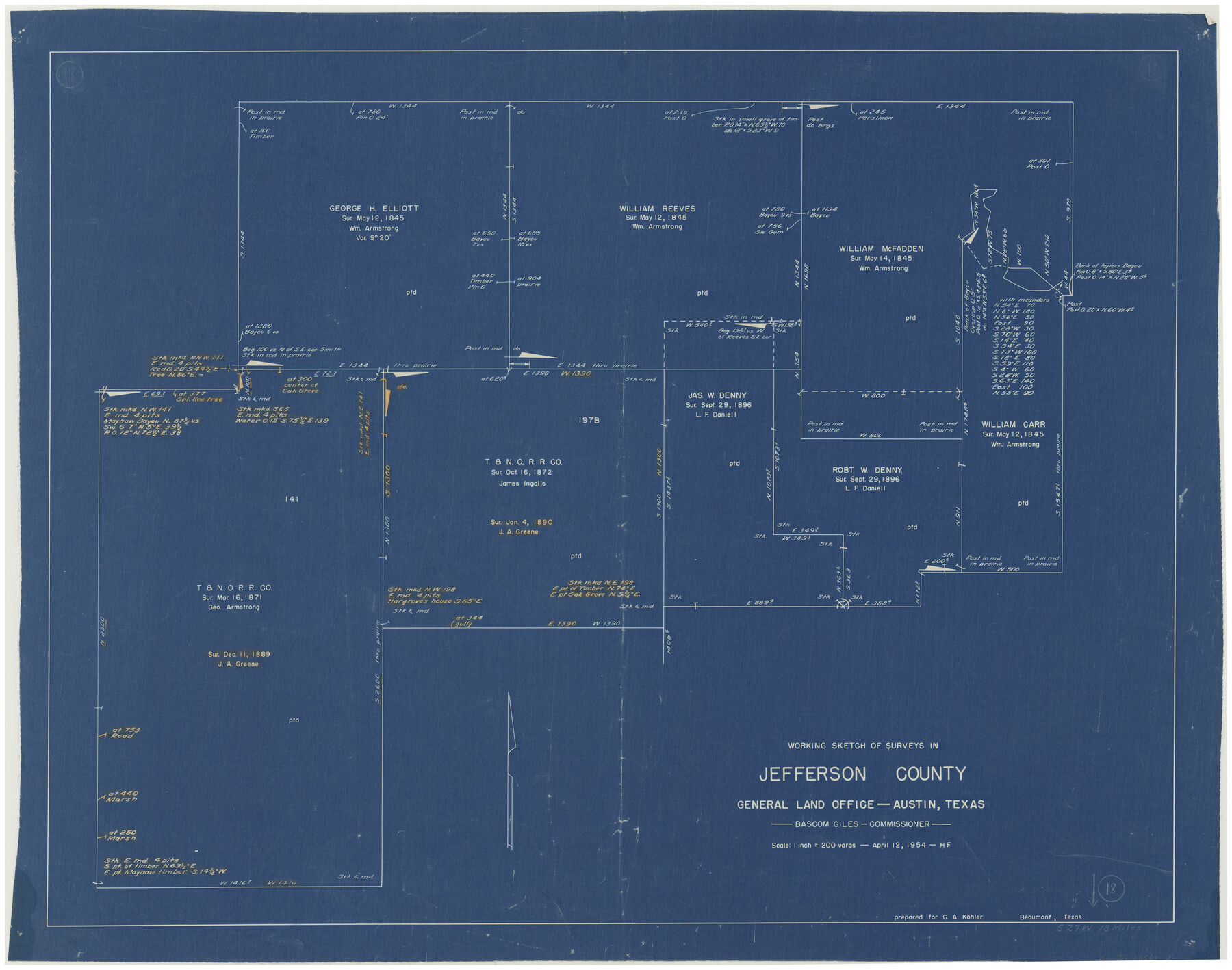
Jefferson County Working Sketch 18
-
Map/Doc
66561
-
Collection
General Map Collection
-
Object Dates
4/12/1954 (Creation Date)
-
People and Organizations
Herman Forbes (Draftsman)
-
Counties
Jefferson
-
Subjects
Surveying Working Sketch
-
Height x Width
24.2 x 30.7 inches
61.5 x 78.0 cm
-
Scale
1" = 200 varas
Part of: General Map Collection
Travis County Sketch File 19-28

Print $12.00
- Digital $50.00
Travis County Sketch File 19-28
1873
Size 8.6 x 7.7 inches
Map/Doc 38317
[John Schrier's league]
![286, [John Schrier's league], General Map Collection](https://historictexasmaps.com/wmedia_w700/maps/286.tif.jpg)
Print $2.00
- Digital $50.00
[John Schrier's league]
1847
Size 7.2 x 8.6 inches
Map/Doc 286
Navigation Maps of Gulf Intracoastal Waterway, Port Arthur to Brownsville, Texas

Print $4.00
- Digital $50.00
Navigation Maps of Gulf Intracoastal Waterway, Port Arthur to Brownsville, Texas
1951
Size 16.7 x 21.5 inches
Map/Doc 65443
Bowie County Sketch File 8d

Print $4.00
- Digital $50.00
Bowie County Sketch File 8d
Size 14.2 x 8.6 inches
Map/Doc 14894
Tarrant County Sketch File 21

Print $4.00
- Digital $50.00
Tarrant County Sketch File 21
Size 12.5 x 8.4 inches
Map/Doc 37725
Flight Mission No. BRE-2P, Frame 69, Nueces County

Print $20.00
- Digital $50.00
Flight Mission No. BRE-2P, Frame 69, Nueces County
1956
Size 18.6 x 22.5 inches
Map/Doc 86764
Lavaca County Sketch File 6

Print $2.00
- Digital $50.00
Lavaca County Sketch File 6
Size 7.3 x 3.2 inches
Map/Doc 29641
[United States]
![97197, [United States], General Map Collection](https://historictexasmaps.com/wmedia_w700/maps/97197.tif.jpg)
Print $20.00
- Digital $50.00
[United States]
1848
Size 17.7 x 37.4 inches
Map/Doc 97197
Brazoria County NRC Article 33.136 Sketch 26

Print $24.00
Brazoria County NRC Article 33.136 Sketch 26
2025
Map/Doc 97471
Kinney County Rolled Sketch 6

Print $20.00
- Digital $50.00
Kinney County Rolled Sketch 6
Size 27.1 x 36.8 inches
Map/Doc 6536
Red River County Working Sketch 85

Print $20.00
- Digital $50.00
Red River County Working Sketch 85
2005
Size 27.4 x 44.0 inches
Map/Doc 83582
Map of Shackelford County, North of the Clearfork of the Brazos River Young - South of il Milam - Land District

Print $20.00
- Digital $50.00
Map of Shackelford County, North of the Clearfork of the Brazos River Young - South of il Milam - Land District
1859
Size 24.8 x 19.9 inches
Map/Doc 4027
You may also like
Goliad County Sketch File 31

Print $6.00
- Digital $50.00
Goliad County Sketch File 31
1897
Size 10.7 x 8.2 inches
Map/Doc 24329
Cameron County Aerial Photograph Index Sheet 7

Print $20.00
- Digital $50.00
Cameron County Aerial Photograph Index Sheet 7
1955
Size 21.8 x 16.2 inches
Map/Doc 83679
Midland County Working Sketch 16

Print $40.00
- Digital $50.00
Midland County Working Sketch 16
1953
Size 61.7 x 32.6 inches
Map/Doc 70996
A true copy of Peck's field book pages 56 to 63 except classification of lands

Print $40.00
- Digital $50.00
A true copy of Peck's field book pages 56 to 63 except classification of lands
Size 6.3 x 69.2 inches
Map/Doc 89716
[Coleman County Sections 359, 360, and 361]
![92552, [Coleman County Sections 359, 360, and 361], Twichell Survey Records](https://historictexasmaps.com/wmedia_w700/maps/92552-1.tif.jpg)
Print $20.00
- Digital $50.00
[Coleman County Sections 359, 360, and 361]
1946
Size 17.6 x 22.6 inches
Map/Doc 92552
Flight Mission No. BQY-4M, Frame 34, Harris County

Print $20.00
- Digital $50.00
Flight Mission No. BQY-4M, Frame 34, Harris County
1953
Size 18.6 x 22.4 inches
Map/Doc 85249
Tarrant County Working Sketch 3

Print $20.00
- Digital $50.00
Tarrant County Working Sketch 3
1948
Size 26.3 x 24.9 inches
Map/Doc 62420
[Sketch for Mineral Application 16696-16697, Pecos River]
![65613, [Sketch for Mineral Application 16696-16697, Pecos River], General Map Collection](https://historictexasmaps.com/wmedia_w700/maps/65613-1.tif.jpg)
Print $40.00
- Digital $50.00
[Sketch for Mineral Application 16696-16697, Pecos River]
Size 36.7 x 68.3 inches
Map/Doc 65613
Plat of tract surveyed for S. W. Inglish

Print $20.00
- Digital $50.00
Plat of tract surveyed for S. W. Inglish
1920
Size 18.2 x 6.7 inches
Map/Doc 90822
Young County Sketch File 5

Print $40.00
- Digital $50.00
Young County Sketch File 5
1855
Size 12.8 x 15.6 inches
Map/Doc 49662
Flight Mission No. BQR-12K, Frame 51, Brazoria County

Print $20.00
- Digital $50.00
Flight Mission No. BQR-12K, Frame 51, Brazoria County
1952
Size 18.8 x 22.4 inches
Map/Doc 84066
Andrews County

Print $40.00
- Digital $50.00
Andrews County
1901
Size 35.9 x 49.7 inches
Map/Doc 4872