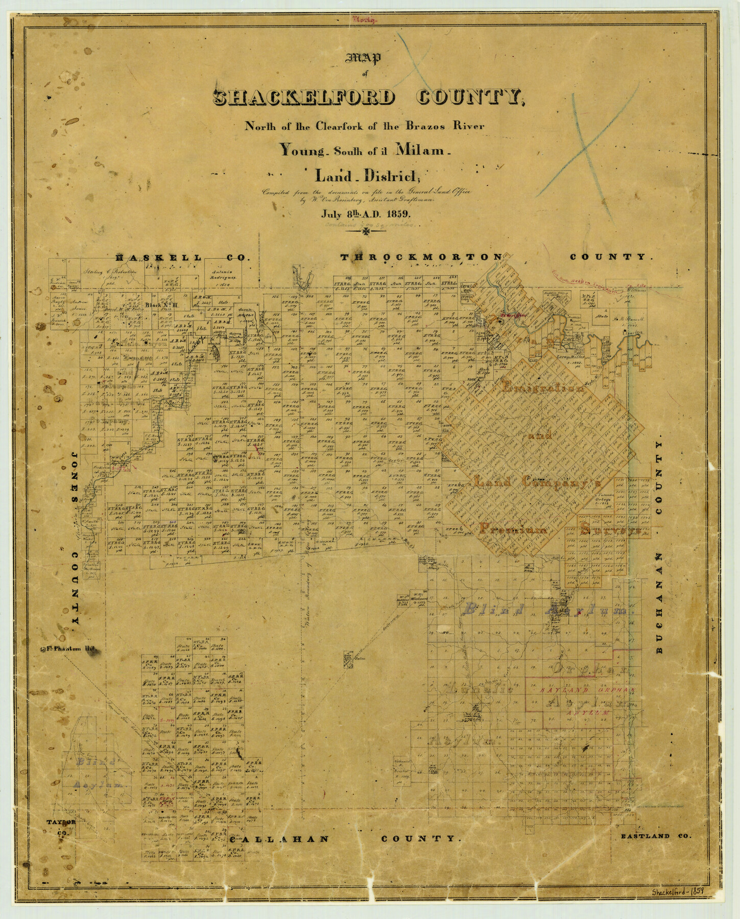
Map of Shackelford County, North of the Clearfork of the Brazos River Young - South of il Milam - Land District
-
Map/Doc
4027
-
Collection
General Map Collection
-
Object Dates
1859/7/8 (Creation Date)
-
People and Organizations
Texas General Land Office (Publisher)
W. von Rosenberg (Draftsman)
W. von Rosenberg (Compiler)
-
Counties
Shackelford
-
Subjects
County
-
Height x Width
24.8 x 19.9 inches
63.0 x 50.5 cm
-
Features
Deep Creek
[Road] from Caddo's Peaks to Camp Cooper
Saline
Buck Creek
Willow Creek
College Creek
Asylum Creek
Fort Phantom Hill
Camp Cooper Road
Caddo Peaks Road
Jennie's Creek
California Creek
South Fork of Mill Creek
Albany
Middle Fork of Mill Creek
North Fork of Mill Creek
West Fork of Hubbards Creek
Mill Creek
Taylor's Creek
Foyle's Creek
Fort Griffin
Clear Fork of Brazos River
Part of: General Map Collection
Gillespie County Working Sketch 12

Print $20.00
- Digital $50.00
Gillespie County Working Sketch 12
2007
Size 37.6 x 38.0 inches
Map/Doc 87903
Hartley County Boundary File 3

Print $15.00
- Digital $50.00
Hartley County Boundary File 3
Size 6.7 x 16.5 inches
Map/Doc 54476
Marion County Boundary File 2

Print $6.00
- Digital $50.00
Marion County Boundary File 2
Size 11.2 x 8.7 inches
Map/Doc 56818
Polk County Sketch File 17

Print $4.00
- Digital $50.00
Polk County Sketch File 17
1861
Size 8.1 x 9.5 inches
Map/Doc 34163
Jeff Davis County Rolled Sketch 6

Print $20.00
- Digital $50.00
Jeff Davis County Rolled Sketch 6
1889
Size 41.3 x 26.4 inches
Map/Doc 6360
Dawson County Working Sketch 2

Print $20.00
- Digital $50.00
Dawson County Working Sketch 2
1937
Size 8.8 x 20.3 inches
Map/Doc 68546

Flight Mission No. BRE-2P, Frame 138, Nueces County

Print $20.00
- Digital $50.00
Flight Mission No. BRE-2P, Frame 138, Nueces County
1956
Size 18.5 x 22.2 inches
Map/Doc 86811

Hood County Sketch File 19

Print $11.00
- Digital $50.00
Hood County Sketch File 19
Size 9.0 x 7.9 inches
Map/Doc 26603
Hardeman County Sketch File 9

Print $20.00
- Digital $50.00
Hardeman County Sketch File 9
1884
Size 27.7 x 30.1 inches
Map/Doc 11624
Township 2 South Range 11 West, South Western District, Louisiana

Print $20.00
- Digital $50.00
Township 2 South Range 11 West, South Western District, Louisiana
1882
Size 19.6 x 24.6 inches
Map/Doc 65881
You may also like
A new and complete county map of all the rail roads in the United States & Canadas in operation & progress.

Print $20.00
A new and complete county map of all the rail roads in the United States & Canadas in operation & progress.
1857
Size 19.3 x 22.0 inches
Map/Doc 93606
South Montgomery County, Woodlands Chamber of Commerce Street Map

South Montgomery County, Woodlands Chamber of Commerce Street Map
Size 50.0 x 37.9 inches
Map/Doc 94363
Travis County Working Sketch 6

Print $20.00
- Digital $50.00
Travis County Working Sketch 6
1913
Size 28.9 x 20.6 inches
Map/Doc 69390
Treaty to Resolve Pending Boundary Differences and Maintain the Rio Grande and Colorado River as the International Boundary Between the United States of American and Mexico

Print $20.00
- Digital $50.00
Treaty to Resolve Pending Boundary Differences and Maintain the Rio Grande and Colorado River as the International Boundary Between the United States of American and Mexico
1970
Size 10.8 x 29.8 inches
Map/Doc 83106
Hamilton County Working Sketch 5

Print $20.00
- Digital $50.00
Hamilton County Working Sketch 5
1941
Size 25.5 x 20.1 inches
Map/Doc 63343
Marion County Sketch File 13

Print $24.00
- Digital $50.00
Marion County Sketch File 13
1912
Size 11.3 x 8.7 inches
Map/Doc 30583
Uvalde County Rolled Sketch 15

Print $20.00
- Digital $50.00
Uvalde County Rolled Sketch 15
1979
Size 26.9 x 23.9 inches
Map/Doc 8099
Flight Mission No. CRC-4R, Frame 76, Chambers County

Print $20.00
- Digital $50.00
Flight Mission No. CRC-4R, Frame 76, Chambers County
1956
Size 18.8 x 22.4 inches
Map/Doc 84880
Right of Way and Track Map of The Missouri, Kansas & Texas Railway of Texas

Print $40.00
- Digital $50.00
Right of Way and Track Map of The Missouri, Kansas & Texas Railway of Texas
1918
Size 25.7 x 107.8 inches
Map/Doc 64532
Uvalde County Rolled Sketch 6

Print $20.00
- Digital $50.00
Uvalde County Rolled Sketch 6
Size 18.6 x 24.2 inches
Map/Doc 8091
Maps of Gulf Intracoastal Waterway, Texas - Sabine River to the Rio Grande and connecting waterways including ship channels

Print $20.00
- Digital $50.00
Maps of Gulf Intracoastal Waterway, Texas - Sabine River to the Rio Grande and connecting waterways including ship channels
1966
Size 14.5 x 22.2 inches
Map/Doc 61922
Flight Mission No. DCL-4C, Frame 147, Kenedy County

Print $20.00
- Digital $50.00
Flight Mission No. DCL-4C, Frame 147, Kenedy County
1943
Size 18.6 x 22.3 inches
Map/Doc 85825