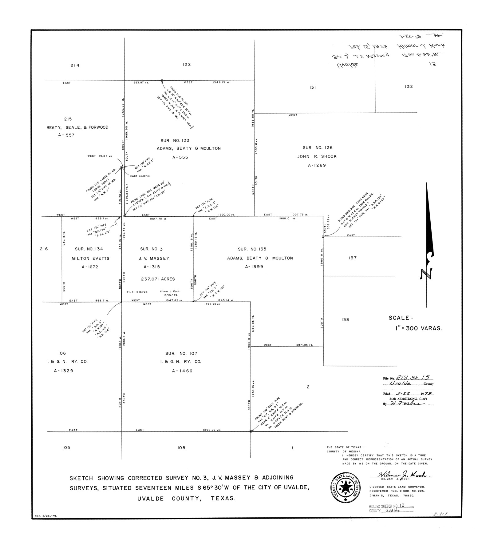
Uvalde County Rolled Sketch 15
Sketch showing corrected survey no. 3, J.V. Massey & adjoining surveys
-
Map/Doc
8099
-
Collection
General Map Collection
-
Object Dates
1979/2/15 (Creation Date)
1979/3/22 (File Date)
-
People and Organizations
Hilmar J. Koch (Surveyor/Engineer)
-
Counties
Uvalde
-
Subjects
Surveying Rolled Sketch
-
Height x Width
26.9 x 23.9 inches
68.3 x 60.7 cm
-
Medium
mylar, print
-
Scale
1" = 300 varas
Part of: General Map Collection
Dawson County Sketch File 16

Print $14.00
- Digital $50.00
Dawson County Sketch File 16
Size 13.4 x 8.8 inches
Map/Doc 20551
Crockett County Sketch File 58

Print $20.00
- Digital $50.00
Crockett County Sketch File 58
1932
Size 17.9 x 23.2 inches
Map/Doc 11226
Flight Mission No. BRA-7M, Frame 120, Jefferson County

Print $20.00
- Digital $50.00
Flight Mission No. BRA-7M, Frame 120, Jefferson County
1953
Size 18.7 x 22.4 inches
Map/Doc 85514
Township 4 South Ranges 12 and 13 West, South Western District, Louisiana

Print $2.00
- Digital $50.00
Township 4 South Ranges 12 and 13 West, South Western District, Louisiana
1968
Size 10.5 x 7.6 inches
Map/Doc 65889
Harris County Historic Topographic 25

Print $20.00
- Digital $50.00
Harris County Historic Topographic 25
1916
Size 29.2 x 22.7 inches
Map/Doc 65836
Williamson County

Print $40.00
- Digital $50.00
Williamson County
1946
Size 37.3 x 54.8 inches
Map/Doc 77460
[Map Showing Parmer, Castro, Bailey, Lamb, Cochran & Hockley Counties, Texas]
![1762, [Map Showing Parmer, Castro, Bailey, Lamb, Cochran & Hockley Counties, Texas], General Map Collection](https://historictexasmaps.com/wmedia_w700/maps/1762.tif.jpg)
Print $40.00
- Digital $50.00
[Map Showing Parmer, Castro, Bailey, Lamb, Cochran & Hockley Counties, Texas]
1910
Size 55.3 x 40.1 inches
Map/Doc 1762
Hartley County Working Sketch 6

Print $20.00
- Digital $50.00
Hartley County Working Sketch 6
1971
Size 37.0 x 37.0 inches
Map/Doc 66056
Map of Harris County

Print $40.00
- Digital $50.00
Map of Harris County
1897
Size 48.4 x 68.5 inches
Map/Doc 82069
Flight Mission No. CRC-3R, Frame 28, Chambers County

Print $20.00
- Digital $50.00
Flight Mission No. CRC-3R, Frame 28, Chambers County
1956
Size 18.8 x 22.4 inches
Map/Doc 84803
Cass County Working Sketch 11

Print $3.00
- Digital $50.00
Cass County Working Sketch 11
Size 14.8 x 10.3 inches
Map/Doc 67914
Gillespie County Boundary File 3a

Print $20.00
- Digital $50.00
Gillespie County Boundary File 3a
Size 24.6 x 37.6 inches
Map/Doc 53753
You may also like
List of County School Lands

Print $20.00
- Digital $50.00
List of County School Lands
Size 18.4 x 23.4 inches
Map/Doc 65798
Trinity River, Hughes Crossing Sheet/Chambers Creek

Print $6.00
- Digital $50.00
Trinity River, Hughes Crossing Sheet/Chambers Creek
1931
Size 32.5 x 30.2 inches
Map/Doc 65239
Map of The Surveyed Part of Peters Colony Texas

Print $40.00
- Digital $50.00
Map of The Surveyed Part of Peters Colony Texas
1852
Size 54.1 x 42.3 inches
Map/Doc 1965
Reconnoissances of Routes from San Antonio de Bexar, El Paso del Norte &c &c

Print $20.00
- Digital $50.00
Reconnoissances of Routes from San Antonio de Bexar, El Paso del Norte &c &c
1849
Size 26.3 x 38.9 inches
Map/Doc 94853
Map of Jefferson as owned by Allen Urquhart

Print $20.00
- Digital $50.00
Map of Jefferson as owned by Allen Urquhart
1850
Size 25.1 x 16.6 inches
Map/Doc 1684
Colorado County Working Sketch 3

Print $20.00
- Digital $50.00
Colorado County Working Sketch 3
1911
Size 23.2 x 19.2 inches
Map/Doc 68103

Newton County Working Sketch 34

Print $20.00
- Digital $50.00
Newton County Working Sketch 34
1959
Size 27.0 x 32.6 inches
Map/Doc 71280
Bee County Sketch File 14

Print $40.00
- Digital $50.00
Bee County Sketch File 14
1878
Size 14.5 x 12.5 inches
Map/Doc 14297
Crane County Rolled Sketch 25

Print $20.00
- Digital $50.00
Crane County Rolled Sketch 25
2019
Size 36.2 x 23.8 inches
Map/Doc 95746
Kleberg County Working Sketch Graphic Index

Print $20.00
- Digital $50.00
Kleberg County Working Sketch Graphic Index
1913
Size 29.0 x 32.9 inches
Map/Doc 76610
Harris County Rolled Sketch 97

Print $20.00
- Digital $50.00
Harris County Rolled Sketch 97
Size 18.8 x 23.6 inches
Map/Doc 6135